The CR8 3 postcode sector is within the county of Greater London.
Did you know? According to the 2021 Census, the CR8 3 postcode sector is home to a bustling 5,210 residents!
Given that each sector allows for 400 unique postcode combinations. Letters C, I, K, M, O and V are not allowed in the last two letters of a postcode. With 141 postcodes already in use, this leaves 259 units available.
The CR8 3 postal code covers the settlement of PURLEY .
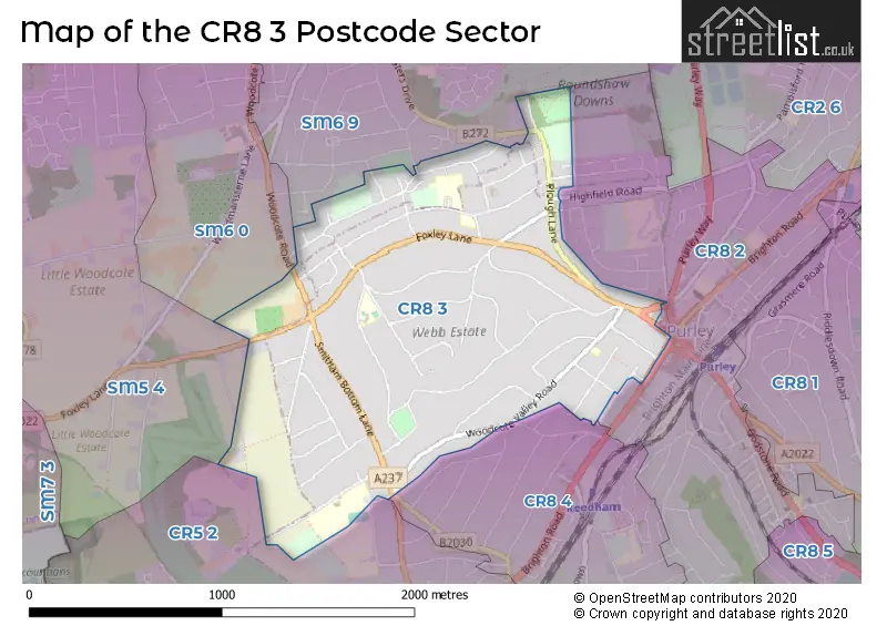
The CR8 3 Postcode shares a border with SM5 4 (CARSHALTON , LITTLE WOODCOTE ESTATE ), SM6 0 (WALLINGTON ), SM6 9 (WALLINGTON ), CR5 2 (COULSDON ), CR8 2 (PURLEY ) and CR8 4 (PURLEY ).
The sector is within the post town of PURLEY.
CR8 3 is a postcode sector within the CR8 postcode district which is within the CR Croydon postcode area.
The Royal Mail delivery office for the CR8 3 postal sector is the Purley Delivery Office.
The area of the CR8 3 postcode sector is 1.15 square miles which is 2.97 square kilometres or 733.03 square acres.

Map of the CR8 3 Postcode Sector
Explore the CR8 3 postcode sector by using our free interactive map.
| C | R | 8 | - | 3 | X | X |
| C | R | 8 | Space | 3 | Letter | Letter |
Official List of Streets
PURLEY (54 Streets)
Unofficial Streets or Alternative Spellings
PURLEY
GROVELANDS ROAD HIGHFIELD ROAD HILLCREST ROAD MANOR WOOD ROAD PURLEY ROAD RUSSELL HILL SMITHAM DOWNS ROAD SOVEREIGN CLOSEHooley
BRIGHTON ROADWALLINGTON
AMBREY WAY FORESTERS DRIVEPURLEY,
WOODCOTE ROADCOULSDON
DUNSFOLD RISE MEADOW RISE WOODCOTE GROVE ROAD BARRINGTON ROADCARSHALTON,
LITTLE WOODCOTE LANESchools and Places of Education Within the CR8 3 Postcode Sector
The John Fisher School
Voluntary aided school
Peaks Hill, Purley, Surrey, CR8 3YP
Head: Mr Robert Teague
Ofsted Rating: Good
Inspection: 2023-06-21 (343 days ago)
Website: Visit The John Fisher School Website
Phone: 02086604555
Number of Pupils: 1163
House Prices in the CR8 3 Postcode Sector
| Type of Property | 2018 Average | 2018 Sales | 2017 Average | 2017 Sales | 2016 Average | 2016 Sales | 2015 Average | 2015 Sales |
|---|---|---|---|---|---|---|---|---|
| Detached | £1,036,938 | 42 | £1,047,046 | 43 | £1,056,186 | 35 | £1,008,846 | 49 |
| Semi-Detached | £760,556 | 9 | £745,000 | 12 | £690,000 | 9 | £668,091 | 11 |
| Terraced | £0 | 0 | £0 | 0 | £390,000 | 1 | £325,000 | 1 |
| Flats | £444,909 | 33 | £338,875 | 16 | £297,650 | 20 | £270,303 | 18 |
Important Postcodes CR8 3 in the Postcode Sector
CR8 3EE is the postcode for Woodcote medical, Purley Surgery, 32 Foxley Lane
CR8 3NF is the postcode for 158, Foxley Lane
CR8 3YH is the postcode for London Borough of Croydon, Purley Library, Banstead Road
CR8 3YP is the postcode for John Fisher School, Peaks Hill, FOUNDERS BUILDING, John Fisher School, Peaks Hill, SPORTS HALL, John Fisher School, Peaks Hill, MAIN BUILDING, John Fisher School, Peaks Hill, SCIENCE/CDT/GYM, John Fisher School, Peaks Hill, and THE SIR DAVID LANE BUILDING, John Fisher School, Peaks Hill
| The CR8 3 Sector is within these Local Authorities |
|
|---|---|
| The CR8 3 Sector is within these Counties |
|
| The CR8 3 Sector is within these Water Company Areas |
|