The CT21 4 postcode sector is within the county of Kent.
Did you know? According to the 2021 Census, the CT21 4 postcode sector is home to a bustling 4,983 residents!
Given that each sector allows for 400 unique postcode combinations. Letters C, I, K, M, O and V are not allowed in the last two letters of a postcode. With 175 postcodes already in use, this leaves 225 units available.
The largest settlement in the CT21 4 postal code is HYTHE followed by Lympne, and Saltwood.
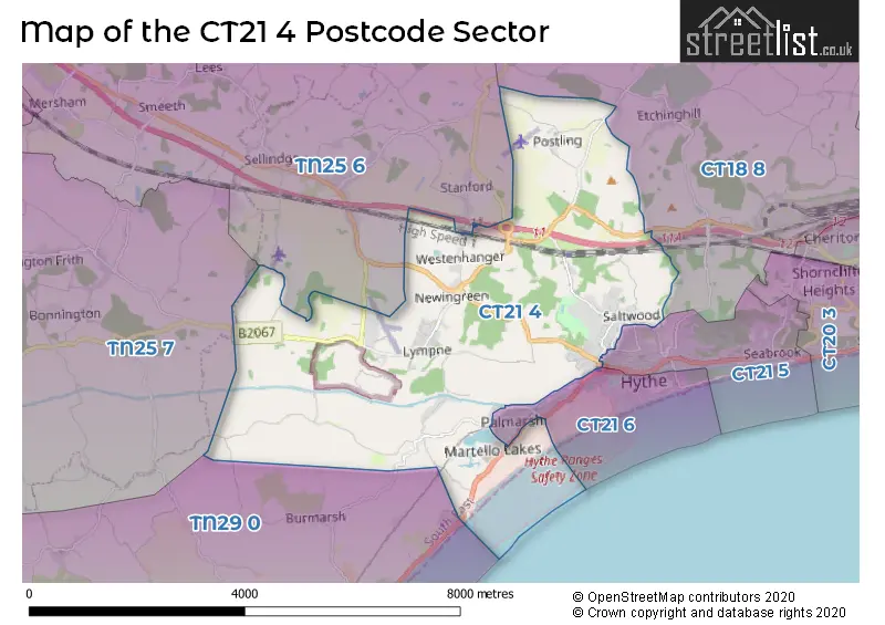
The CT21 4 Postcode shares a border with TN25 6 (Sellindge, Smeeth, Mersham), TN25 7 (Aldington, Kingsnorth, Finberry), CT21 5 (HYTHE), TN29 0 (Dymchurch, St. Marys Bay, Burmarsh), CT18 8 (Lyminge, Etchinghill, Acrise) and CT21 6 (HYTHE).
The sector is within the post town of HYTHE.
CT21 4 is a postcode sector within the CT21 postcode district which is within the CT Canterbury postcode area.
The Royal Mail delivery office for the CT21 4 postal sector is the Hythe (ct) Delivery Office.
The area of the CT21 4 postcode sector is 12.75 square miles which is 33.03 square kilometres or 8,162.88 square acres.
The CT21 4 postcode sector is crossed by the M20 motorway.
Waterways within the CT21 4 postcode sector include the East Stour, Royal Military Canal.

Map of the CT21 4 Postcode Sector
Explore the CT21 4 postcode sector by using our free interactive map.
| C | T | 2 | 1 | - | 4 | X | X |
| C | T | 2 | 1 | Space | 4 | Letter | Letter |
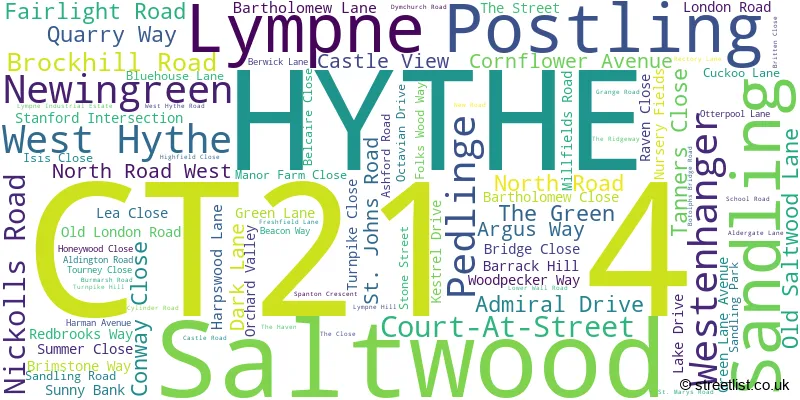
Official List of Streets
HYTHE (50 Streets)
West Hythe (5 Streets)
Lympne (16 Streets)
Newingreen (2 Streets)
Saltwood (13 Streets)
Postling (3 Streets)
Sandling (2 Streets)
Unofficial Streets or Alternative Spellings
Saltwood
CONWAY CLOSE BULMARSH ROAD CASTLE CLOSE DADDY SWAN FOLKS WOOD BYWAY HYTHE ROAD MEADOW COURT MONKEY BUSINESS ORCHARD FIELDS POSTLING COURT REACH ROAD RIDGEWAY ROYAL MILITARY ROAD SEA WALL ST GEORGES PLACE STANFORD INTERCHANGE TAME LANE TANNERS HILL THE COPPICE TOLSFORD HILL ZOO RUNHYTHE
HILLCREST ROAD MILITARY ROAD PALMARSH AVENUE PALMBEACH AVENUE SCANLONS BRIDGE ROAD SEATON AVENUE SIR JOHN MOORE AVENUELyminge
SANDLING ROADSellindge
HARRINGE LANEAldington
KNOLL HILLBurmarsh
DONKEY STREETWeather Forecast for CT21 4
Press Button to Show Forecast for Westenhanger
| Time Period | Icon | Description | Temperature | Rain Probability | Wind |
|---|---|---|---|---|---|
| 06:00 to 09:00 | Cloudy | 12.0°C (feels like 11.0°C) | 11.00% | E 4 mph | |
| 09:00 to 12:00 | Cloudy | 13.0°C (feels like 13.0°C) | 42.00% | ENE 7 mph | |
| 12:00 to 15:00 | Cloudy | 16.0°C (feels like 15.0°C) | 9.00% | ENE 7 mph | |
| 15:00 to 18:00 | Cloudy | 16.0°C (feels like 15.0°C) | 4.00% | NE 9 mph | |
| 18:00 to 21:00 | Cloudy | 15.0°C (feels like 14.0°C) | 5.00% | N 9 mph | |
| 21:00 to 00:00 | Cloudy | 12.0°C (feels like 10.0°C) | 16.00% | N 11 mph |
Press Button to Show Forecast for Westenhanger
| Time Period | Icon | Description | Temperature | Rain Probability | Wind |
|---|---|---|---|---|---|
| 00:00 to 03:00 | Cloudy | 11.0°C (feels like 9.0°C) | 49.00% | N 11 mph | |
| 03:00 to 06:00 | Cloudy | 11.0°C (feels like 9.0°C) | 10.00% | N 9 mph | |
| 06:00 to 09:00 | Cloudy | 12.0°C (feels like 10.0°C) | 10.00% | N 7 mph | |
| 09:00 to 12:00 | Cloudy | 14.0°C (feels like 13.0°C) | 6.00% | WNW 7 mph | |
| 12:00 to 15:00 | Partly cloudy (day) | 16.0°C (feels like 15.0°C) | 5.00% | W 9 mph | |
| 15:00 to 18:00 | Cloudy | 16.0°C (feels like 15.0°C) | 11.00% | WNW 9 mph | |
| 18:00 to 21:00 | Partly cloudy (day) | 15.0°C (feels like 13.0°C) | 9.00% | NW 9 mph | |
| 21:00 to 00:00 | Cloudy | 13.0°C (feels like 11.0°C) | 13.00% | NW 9 mph |
Press Button to Show Forecast for Westenhanger
| Time Period | Icon | Description | Temperature | Rain Probability | Wind |
|---|---|---|---|---|---|
| 00:00 to 03:00 | Overcast | 11.0°C (feels like 9.0°C) | 15.00% | W 11 mph | |
| 03:00 to 06:00 | Overcast | 11.0°C (feels like 9.0°C) | 17.00% | W 11 mph | |
| 06:00 to 09:00 | Overcast | 11.0°C (feels like 8.0°C) | 23.00% | W 11 mph | |
| 09:00 to 12:00 | Overcast | 12.0°C (feels like 9.0°C) | 23.00% | W 13 mph | |
| 12:00 to 15:00 | Overcast | 13.0°C (feels like 10.0°C) | 18.00% | WSW 13 mph | |
| 15:00 to 18:00 | Cloudy | 14.0°C (feels like 11.0°C) | 14.00% | WSW 16 mph | |
| 18:00 to 21:00 | Cloudy | 13.0°C (feels like 11.0°C) | 11.00% | WSW 13 mph | |
| 21:00 to 00:00 | Cloudy | 11.0°C (feels like 9.0°C) | 8.00% | WSW 11 mph |
Press Button to Show Forecast for Westenhanger
| Time Period | Icon | Description | Temperature | Rain Probability | Wind |
|---|---|---|---|---|---|
| 00:00 to 03:00 | Partly cloudy (night) | 10.0°C (feels like 8.0°C) | 4.00% | WSW 11 mph | |
| 03:00 to 06:00 | Clear night | 9.0°C (feels like 7.0°C) | 4.00% | WSW 9 mph | |
| 06:00 to 09:00 | Sunny day | 10.0°C (feels like 8.0°C) | 4.00% | WSW 9 mph | |
| 09:00 to 12:00 | Partly cloudy (day) | 13.0°C (feels like 11.0°C) | 4.00% | WSW 11 mph | |
| 12:00 to 15:00 | Cloudy | 14.0°C (feels like 12.0°C) | 8.00% | SW 13 mph | |
| 15:00 to 18:00 | Partly cloudy (day) | 14.0°C (feels like 12.0°C) | 6.00% | SSW 11 mph | |
| 18:00 to 21:00 | Sunny day | 14.0°C (feels like 12.0°C) | 3.00% | SSW 9 mph | |
| 21:00 to 00:00 | Partly cloudy (night) | 11.0°C (feels like 9.0°C) | 3.00% | S 9 mph |
Schools and Places of Education Within the CT21 4 Postcode Sector
Brockhill Park Performing Arts College
Academy converter
Sandling Road, Hythe, Kent, CT21 4HL
Head: Mr Charles Joseph
Ofsted Rating: Good
Inspection: 2021-10-13 (931 days ago)
Website: Visit Brockhill Park Performing Arts College Website
Phone: 01303265521
Number of Pupils: 1351
Lympne Church of England Primary School
Voluntary controlled school
Octavian Drive, Hythe, Kent, CT21 4JG
Head: Mrs Melanie Nash
Ofsted Rating: Good
Inspection: 2021-10-14 (930 days ago)
Website: Visit Lympne Church of England Primary School Website
Phone: 01303268041
Number of Pupils: 203
Saltwood CofE Primary School
Voluntary aided school
Grange Road, Hythe, Kent, CT21 4QS
Head: Mr Paul Newton
Ofsted Rating: Good
Inspection: 2022-05-11 (721 days ago)
Website: Visit Saltwood CofE Primary School Website
Phone: 01303266058
Number of Pupils: 208
House Prices in the CT21 4 Postcode Sector
| Type of Property | 2018 Average | 2018 Sales | 2017 Average | 2017 Sales | 2016 Average | 2016 Sales | 2015 Average | 2015 Sales |
|---|---|---|---|---|---|---|---|---|
| Detached | £433,464 | 63 | £431,668 | 56 | £446,298 | 65 | £365,526 | 52 |
| Semi-Detached | £300,217 | 35 | £324,115 | 25 | £334,199 | 20 | £351,941 | 17 |
| Terraced | £245,312 | 11 | £268,953 | 19 | £235,624 | 16 | £226,708 | 12 |
| Flats | £217,178 | 22 | £212,500 | 2 | £275,000 | 3 | £276,667 | 3 |
Important Postcodes CT21 4 in the Postcode Sector
CT21 4BE is the postcode for St Augustines Roman Catholic Primary School, St Johns Road, St. Augustine's Catholic Primary School, St. Johns Road, and ST AUGUSTINES ROMAN CATHOLIC PRIMARY SCHOOL, ST JOHNS ROAD, HYTHE
CT21 4HL is the postcode for SINCLAIR BLOCK, Brockhill Park Performing Arts College, Sandling Road, FRANK LLOYD WRIGHT BUILDING, Brockhill Park Performing Arts College, Sandling Road, PENROSE B BLOCK, Brockhill Park Performing Arts College, Sandling Road, MANSION BLOCK, Brockhill Park Performing Arts College, Sandling Road, SPORTS HALL, Brockhill Park Performing Arts College, Sandling Road, ROWNTREE, Brockhill Park Performing Arts College, Sandling Road, PENROSE A BLOCK, Brockhill Park Performing Arts College, Sandling Road, COMENIUS BLOCK, Brockhill Park Performing Arts College, Sandling Road, WELLS BLOCK, Brockhill Park Performing Arts College, Sandling Road, SAGA BLOCK, Brockhill Park Performing Arts College, Sandling Road, Brockhill Park Performing Arts College, Sandling Road, and DINING HALL, Brockhill Park Performing Arts College, Sandling Road
CT21 4JG is the postcode for LYMPNE CHURCH OF ENGLAND PRIMARY SCHOOL, OCTAVIAN DRIVE, LYMPNE, Lympne C of E Primary School, Octavian Drive, and Lympne Church Of England Primary School, Octavian Drive
CT21 4QS is the postcode for Saltwood C of E Primary School, Grange Road, and SALTWOOD CHURCH OF ENGLAND PRIMARY SCHOOL, GRANGE ROAD
| The CT21 4 Sector is within these Local Authorities |
|
|---|---|
| The CT21 4 Sector is within these Counties |
|
| The CT21 4 Sector is within these Water Company Areas |
|