This section of the site is all about the CT Postcode area, also known as the Canterbury Postal Area. Explore links to the next level to learn more about specific postcode districts such as CT1.
The CT postcode area represents a group of postal districts in the Canterbury area of the United Kingdom. The area code CT stands for the letters c and t in CanTerbury. CT has a population of 482,504 and covers an area of 917,250 hectares. Fun fact: 0.74% of the population of Great Britain lives in this area.
The postcode area falls within the following counties: Kent (100.00%).
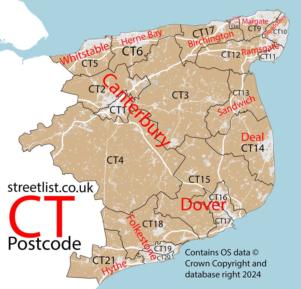
Post Towns and Postcode Districts for the CT Postcode
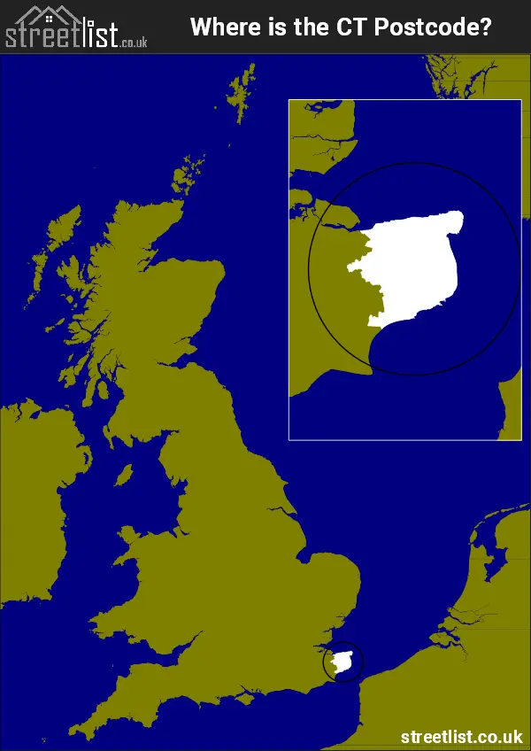
Where is the CT Postcode Area?
The CT Canterbury Postcode is in the South East of England The postal area borders the following neighbouring postal areas: ME - Medway and TN - Tonbridge, It also borders The Strait of Dover and The Thames Estuary.
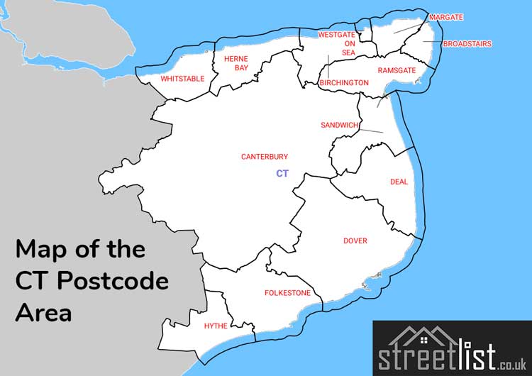
Map of the CT Canterbury Postcode Area
Explore the CT Canterbury postcode area by using our interactive map.
Postcode Districts within the CT Canterbury Postcode Area
There are 21 postcode districts within the Canterbury postcode area

A map showing the boundary of in relation to other areas
There are 10 towns within the Canterbury postcode area.
| Unit | Area² |
|---|---|
| Hectares | 917,250² |
| Miles | 3,542² |
| Feet | 98,731,872,750² |
| Kilometres | 9,173² |
Postal Delivery Offices serving the CT Canterbury Postcode Area
- Ash Scale Payment Delivery Office
- Aylesham Scale Payment Delivery Office
- Barham Scale Payment Delivery Office
- Broadstairs Delivery Office
- Canterbury Delivery Office
- Deal Delivery Office
- Dover Delivery Office
- Folkestone Delivery Office
- Herne Bay Delivery Office
- Hythe (ct) Delivery Office
- Margate Delivery Office
- Minster Scale Payment Delivery Office
- Ramsgate Delivery Office
- Sandwich Delivery Office
- Whitstable Delivery Office
- Wingham Scale Payment Delivery Office
Councils with Postcodes in CT
Towns and Villages within the CT Canterbury Postcode Area
- Acol - village
- Adisham - village
- Alkham - village
- Ash - village
- Ashley - village
- Aylesham - village
- Barham - village
- Barnsole - village
- Bekesbourne - village
- Bekesbourne Hill - village
- Betteshanger - otherSettlement
- Bishopsbourne - village
- Blean - village
- Bossingham - village
- Boyden Gate - village
- Bridge - village
- Broad Oak - village
- Broadstairs - town
- Broomfield - village
- Canterbury - city
- Capel-le-Ferne - village
- Chartham - village
- Chartham Hatch - village
- Chilham - village
- Chillenden - village
- Cliffs End - village
- Coldred - village
- Deal - town
- Densole - village
- Denton - village
- Derringstone - village
- Dover - town
- Dymchurch - village
- East Langdon - village
- East Stourmouth - village
- East Studdal - village
- Eastry - village
- Eddington - village
- Elham - village
- Elmstone - village
- Elvington - village
- Etchinghill - village
- Ewell Minnis - village
- Eythorne - village
- Felderland - village
- Finglesham - village
- Folkestone - town
- Fordwich - village
- Godmersham - village
- Goodnestone - village
- Great Mongeham - village
- Great Stonar - otherSettlement
- Greenhill - village
- Guilton - village
- Guston - village
- Haine - village
- Harbledown - village
- Hawkinge - village
- Herne - village
- Herne Bay - town
- Herne Common - village
- Hersden - village
- Hoath - village
- Hunters Forstal - village
- Hythe - town
- Ickham - village
- Kingsdown - village
- Kingston - village
- Littlebourne - village
- Lodge Lees - otherSettlement
- Lower Hardres - village
- Lydden - village
- Lydden - village
- Lyminge - village
- Lympne - village
- Manston - village
- Margate - town
- Marshborough - village
- Martin - village
- Martin Mill - village
- Maypole - village
- Minster - village
- Molash - village
- Monkton - village
- Newingreen - village
- Newington - village
- Nonington - village
- Northbourne - village
- Old Wives Lees - village
- Patrixbourne - village
- Peene - village
- Petham - village
- Postling - village
- Preston - village
- Radfall - village
- Ramsgate - town
- Rhodes Minnis - village
- Richborough Port - otherSettlement
- Ringwould - village
- Ripple - village
- Rough Common - village
- Saltwood - village
- Sandwich - town
- Sandwich Bay Estate - village
- Sarre - village
- Shalmsford Street - village
- Shatterling - village
- Sholden - village
- Shottenden - village
- Sibertswold / Shepherdswell - village
- Snowdown - village
- St Margaret's at Cliffe - village
- St Nicholas at Wade - village
- Staple - village
- Stelling Minnis - village
- Stodmarsh - village
- Street End - village
- Sturry - village
- Sutton - village
- Tilmanstone - village
- Tyler Hill - village
- Upper Harbledown - village
- Upstreet - village
- Waltham - village
- West Hougham - village
- West Hythe - village
- West Stourmouth - village
- Westbere - village
- Westmarsh - village
- Whitfield - village
- Whitstable - town
- Wickhambreaux - village
- Wingham - village
- Wingham Green - village
- Woodnesborough - village
- Woolage Green - village
- Woolage Village - village
- Wootton - village
- Worth - village
- Yorkletts - village