The CT9 postcode district is a postal district located in the CT Canterbury postcode area with a population of 46,355 residents according to the 2021 England and Wales Census.
The area of the CT9 postcode district is 6.14 square miles which is 15.90 square kilometres or 3,928.73 acres.
Currently, the CT9 district has about 1151 postcode units spread across 5 geographic postcode sectors.
Given that each sector allows for 400 unique postcode combinations, the district has a capacity of 2,000 postcodes. With 1151 postcodes already in use, this leaves 849 units available.
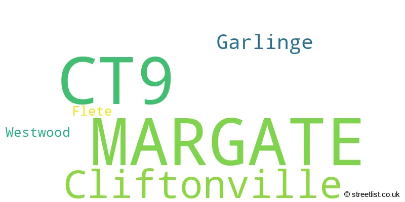
The largest settlements in the CT9 postal code are MARGATE and Cliftonville.
The postcode area has a boundary with Thames Estuary.
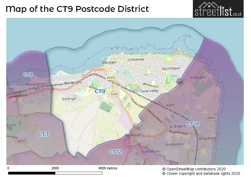
The CT9 Postcode shares a border with CT12 (RAMSGATE, Minster, Manston), CT10 (BROADSTAIRS, St. Peters) and CT8 (WESTGATE-ON-SEA).
The primary settlement in the CT9 postcode district is Margate, located in the county of Kent, England. Other significant settlements include Cliftonville, Flete, Westwood, and Garlinge, all also within Margate.
For the district CT9, we have data on 6 postcode sectors. Here's a breakdown: The sector CT9 1, covers Margate in Kent. The sector CT9 2, covers Margate and Cliftonville in Kent. The sector CT9 3, covers Margate and Cliftonville in Kent. The sector CT9 4, covers Margate in Kent. The sector CT9 5, covers Margate in Kent. The sector CT9 9 is non-geographic. It's often designated for PO Boxes, large organisations, or special services.

Map of the CT9 Postcode District
Explore the CT9 postcode district by using our free interactive map.
When it comes to local government, postal geography often disregards political borders. However, for a breakdown in the CT9 District: the district mostly encompasses the Thanet District area with a total of 1176 postcodes.
Weather Forecast for CT9
Press Button to Show Forecast for Margate
| Time Period | Icon | Description | Temperature | Rain Probability | Wind |
|---|---|---|---|---|---|
| 12:00 to 15:00 | Cloudy | 12.0°C (feels like 10.0°C) | 7.00% | ESE 9 mph | |
| 15:00 to 18:00 | Cloudy | 12.0°C (feels like 10.0°C) | 12.00% | E 11 mph | |
| 18:00 to 21:00 | Light rain | 11.0°C (feels like 8.0°C) | 59.00% | ENE 13 mph | |
| 21:00 to 00:00 | Heavy rain | 11.0°C (feels like 8.0°C) | 89.00% | ENE 13 mph |
Press Button to Show Forecast for Margate
| Time Period | Icon | Description | Temperature | Rain Probability | Wind |
|---|---|---|---|---|---|
| 00:00 to 03:00 | Heavy rain | 11.0°C (feels like 8.0°C) | 92.00% | E 13 mph | |
| 03:00 to 06:00 | Heavy rain | 11.0°C (feels like 8.0°C) | 84.00% | SE 13 mph | |
| 06:00 to 09:00 | Light rain shower (day) | 10.0°C (feels like 8.0°C) | 42.00% | S 16 mph | |
| 09:00 to 12:00 | Heavy rain shower (day) | 11.0°C (feels like 8.0°C) | 58.00% | SW 18 mph | |
| 12:00 to 15:00 | Light rain shower (day) | 11.0°C (feels like 8.0°C) | 42.00% | WSW 20 mph | |
| 15:00 to 18:00 | Cloudy | 11.0°C (feels like 8.0°C) | 18.00% | WSW 18 mph | |
| 18:00 to 21:00 | Sunny day | 11.0°C (feels like 8.0°C) | 6.00% | WSW 11 mph | |
| 21:00 to 00:00 | Clear night | 8.0°C (feels like 6.0°C) | 3.00% | SW 11 mph |
Press Button to Show Forecast for Margate
| Time Period | Icon | Description | Temperature | Rain Probability | Wind |
|---|---|---|---|---|---|
| 00:00 to 03:00 | Clear night | 7.0°C (feels like 5.0°C) | 2.00% | SW 9 mph | |
| 03:00 to 06:00 | Clear night | 7.0°C (feels like 5.0°C) | 2.00% | SSW 7 mph | |
| 06:00 to 09:00 | Sunny day | 9.0°C (feels like 6.0°C) | 1.00% | S 9 mph | |
| 09:00 to 12:00 | Cloudy | 12.0°C (feels like 10.0°C) | 4.00% | S 9 mph | |
| 12:00 to 15:00 | Partly cloudy (day) | 13.0°C (feels like 11.0°C) | 3.00% | S 11 mph | |
| 15:00 to 18:00 | Sunny day | 13.0°C (feels like 11.0°C) | 1.00% | SSE 11 mph | |
| 18:00 to 21:00 | Sunny day | 12.0°C (feels like 11.0°C) | 2.00% | SSE 9 mph | |
| 21:00 to 00:00 | Partly cloudy (night) | 10.0°C (feels like 8.0°C) | 3.00% | SE 9 mph |
Press Button to Show Forecast for Margate
| Time Period | Icon | Description | Temperature | Rain Probability | Wind |
|---|---|---|---|---|---|
| 00:00 to 03:00 | Cloudy | 9.0°C (feels like 8.0°C) | 7.00% | ESE 9 mph | |
| 03:00 to 06:00 | Clear night | 9.0°C (feels like 7.0°C) | 5.00% | ESE 9 mph | |
| 06:00 to 09:00 | Overcast | 10.0°C (feels like 9.0°C) | 12.00% | ESE 9 mph | |
| 09:00 to 12:00 | Cloudy | 12.0°C (feels like 11.0°C) | 9.00% | SE 9 mph | |
| 12:00 to 15:00 | Cloudy | 14.0°C (feels like 12.0°C) | 10.00% | SE 9 mph | |
| 15:00 to 18:00 | Cloudy | 15.0°C (feels like 13.0°C) | 10.00% | ESE 9 mph | |
| 18:00 to 21:00 | Light rain | 13.0°C (feels like 12.0°C) | 52.00% | E 9 mph | |
| 21:00 to 00:00 | Light rain | 12.0°C (feels like 11.0°C) | 52.00% | E 9 mph |
Where is the CT9 Postcode District?
The data shows that the postcode district CT9 is located in the town of Margate. Margate is situated near several nearby towns, including Broadstairs to the East, Birchington to the West, Ramsgate to the South, and Canterbury to the Southwest. Additionally, Margate is approximately 65.9 miles away from the center of London.
The district covers the post towns of BIRCHINGTON, MARGATE.
The sector has postcodes within the nation of England.
The CT9 Postcode District is in the East Kent region of Kent within the South East (England).
| Postcode Sector | Delivery Office |
|---|---|
| CT9 1 | Margate Delivery Office |
| CT9 2 | Margate Delivery Office |
| CT9 3 | Margate Delivery Office |
| CT9 4 | Margate Delivery Office |
| C | T | 9 | - | X | X | X |
| C | T | 9 | Space | Numeric | Letter | Letter |
Current Monthly Rental Prices
| # Bedrooms | Min Price | Max Price | Avg Price |
|---|---|---|---|
| £70 | £70 | £70 | |
| 1 | £695 | £900 | £769 |
| 2 | £575 | £1,500 | £1,048 |
| 3 | £1,000 | £2,000 | £1,307 |
| 4 | £1,200 | £1,200 | £1,200 |
Current House Prices
| # Bedrooms | Min Price | Max Price | Avg Price |
|---|---|---|---|
| £19,000 | £250,000 | £113,000 | |
| 1 | £20,000 | £425,000 | £143,887 |
| 2 | £33,000 | £522,500 | £248,820 |
| 3 | £126,000 | £950,000 | £352,419 |
| 4 | £248,000 | £950,000 | £484,618 |
| 5 | £313,500 | £1,195,000 | £562,300 |
| 6 | £325,000 | £1,100,000 | £576,765 |
| 7 | £495,000 | £575,000 | £521,667 |
| 8 | £500,000 | £950,000 | £697,500 |
| 9 | £550,000 | £930,000 | £746,833 |
| 10 | £1,125,000 | £1,125,000 | £1,125,000 |
| 11 | £575,000 | £575,000 | £575,000 |
| 13 | £825,000 | £825,000 | £825,000 |
| 14 | £575,000 | £575,000 | £575,000 |
| 15 | £825,000 | £825,000 | £825,000 |
Estate Agents who Operate in the CT9 District
| Logo | Name | Brand Name | Address | Contact Number | Total Properties |
|---|---|---|---|---|---|
 | Margate | Miles & Barr | 155-157 Northdown Road, Cliftonville, Margate, CT9 2QY | 01843 260838 | 127 |
 | Margate | Oakwood Homes | Stockwell House, Cecil Square, Margate, CT9 1BD | 01843 260837 | 93 |
 | Cliftonville | Wards | 143 Northdown Road Cliftonville Kent CT9 2QY | 01843 264765 | 75 |
 | Cliftonville | Cooke & Co | 147 Northdown Road, Cliftonville, Margate, CT9 2QY | 01843 261494 | 56 |
 | Cliftonville | Lovetts Property Services | 177 Northdown Road, Cliftonville, Margate, CT9 2PA | 01843 265283 | 27 |
| Type of Property | 2018 Average | 2018 Sales | 2017 Average | 2017 Sales | 2016 Average | 2016 Sales | 2015 Average | 2015 Sales |
|---|---|---|---|---|---|---|---|---|
| Detached | £389,121 | 120 | £343,834 | 134 | £342,209 | 132 | £288,140 | 135 |
| Semi-Detached | £276,560 | 178 | £257,767 | 207 | £237,165 | 225 | £202,440 | 181 |
| Terraced | £227,518 | 258 | £212,712 | 369 | £192,827 | 346 | £161,556 | 355 |
| Flats | £142,945 | 277 | £131,945 | 420 | £123,510 | 354 | £92,031 | 285 |