This section of the site is all about the TN Postcode area, also known as the Tonbridge Postal Area. Explore links to the next level to learn more about specific postcode districts such as TN1.
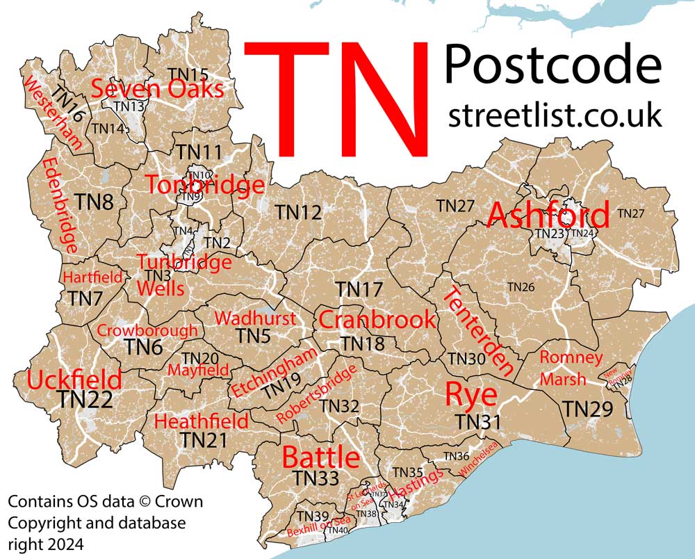
The TN postcode area represents a group of postal districts in the Tonbridge area of the United Kingdom. The area code TN stands for the letters t and n in ToNbridge. TN has a population of 680,816 and covers an area of 2,703,909 hectares. Fun fact: 1.05% of the population of Great Britain lives in this area.
The postcode area falls within the following counties: Kent (61.57%), East Sussex (36.44%), Greater London (1.60%), Surrey (0.38%).
Post Towns and Postcode Districts for the TN Postcode
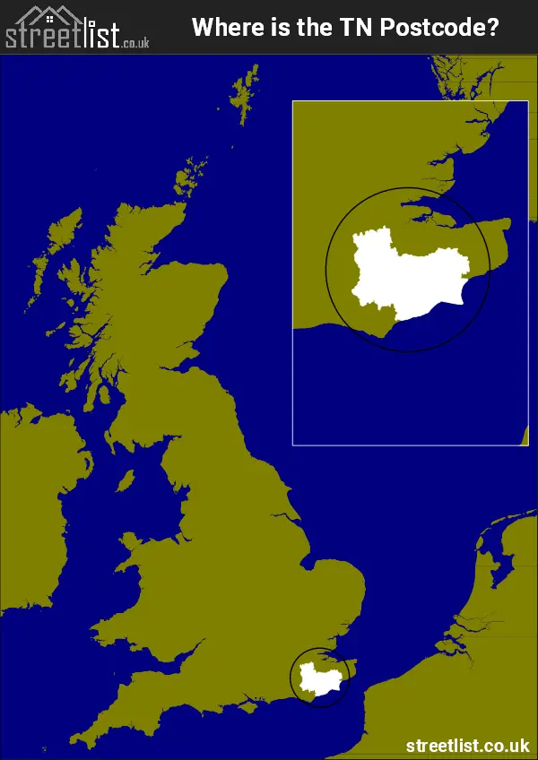
Where is the TN Postcode Area?
The TN Tonbridge Postcode is in the South East of England The postal area borders the following neighbouring postal areas: DA - Dartford, CR - Croydon, CT - Canterbury, BR - Bromley, BN - Brighton, RH - Redhill and ME - Medway, It also borders The Strait of Dover and The English Channel.
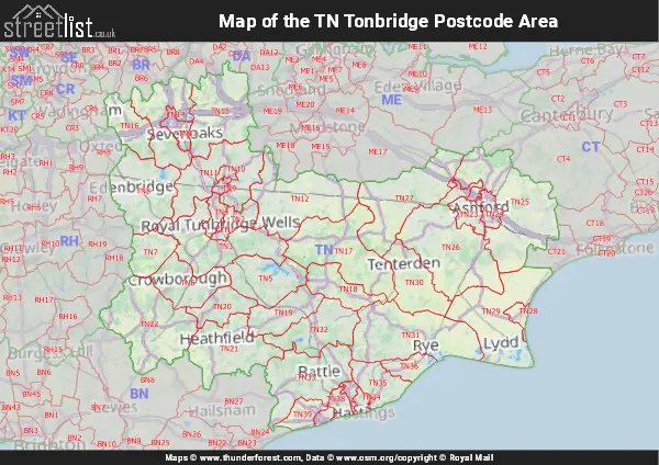
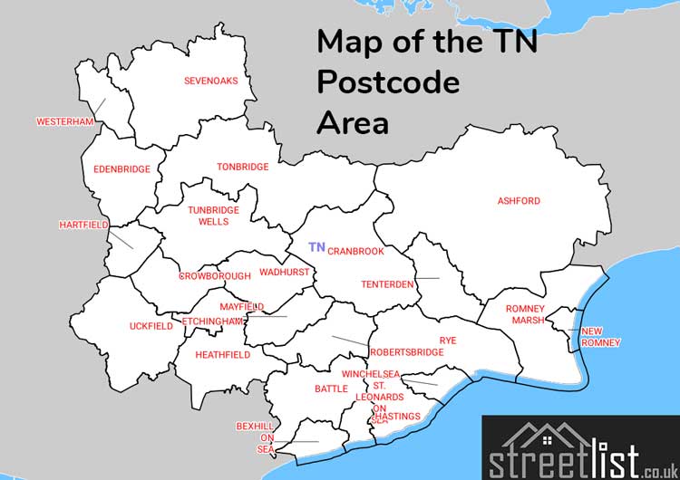
Map of the TN Tonbridge Postcode Area
Explore the TN Tonbridge postcode area by using our interactive map.
Postcode Districts within the TN Tonbridge Postcode Area
There are 40 postcode districts within the Tonbridge postcode area
A map showing the boundary of in relation to other areas
There are 19 towns within the Tonbridge postcode area.
| Unit | Area² |
|---|---|
| Hectares | 2,703,909² |
| Miles | 10,440² |
| Feet | 291,046,060,851² |
| Kilometres | 27,039² |
Postal Delivery Offices serving the TN Tonbridge Postcode Area
- Apple Delivery Office Re Scale Payment Delivery Office
- Ashford (tn) Delivery Office
- Battle Delivery Office
- Bethersden Scale Payment Delivery Office
- Bexhill On Sea Delivery Office
- Biggin Hill Delivery Office
- Brabourne Lees Scale Payment Delivery Office
- Charing Scale Payment Delivery Office
- Cranbrook Delivery Office
- Crowborough Delivery Office
- Edenbridge Delivery Office
- Egerton Scale Payment Delivery Office
- Etchingham Scale Payment Delivery Office
- Hastings Delivery Office
- Headcorn Scale Payment Delivery Office
- Heathfield Delivery Office
- Marden Scale Payment Delivery Office
- New Romney Delivery Office
- Robertsbridge Scale Payment Delivery Office
- Rye Delivery Office
- Sevenoaks Delivery Office
- Smarden Scale Payment Delivery Office
- St Leonards On Sea Delivery Office
- Staplehurst Scale Payment Delivery Office
- Tenterden Delivery Office
- Tonbridge Delivery Office
- Tunbridge Wells Delivery Office
- Uckfield Delivery Office
- Woodchurch Scale Payment Delivery Office
Councils with Postcodes in TN
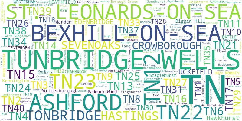
Towns and Villages within the TN Tonbridge Postcode Area
- Aldington - village
- Aldington Frith - village
- Appledore - village
- Appledore Heath - village
- Ash - village
- Ashford - town
- Ashurst - village
- Bachelor's Bump - village
- Badgers Mount - village
- Balls Green - village
- Barnes Street - village
- Barrowhill - village
- Basted - village
- Battle - town
- Beckley - village
- Bedgebury Cross - village
- Bells Yew Green - village
- Benenden - village
- Berry's Green - village
- Bethersden - village
- Bexhill - town
- Bidborough - village
- Biddenden - village
- Biggin Hill - Urban Area
- Bilsington - village
- Bilting - village
- Blackboys - village
- Bodiam - village
- Bonnington - village
- Borough Green - village
- Bough Beech - village
- Boughton Lees - village
- Brabourne - village
- Brabourne Lees - village
- Brandfold - village
- Brasted - village
- Brasted Chart - village
- Brede - village
- Brenchley - village
- Broad Oak - village
- Broad Oak - village
- Bromley Green - village
- Brook - village
- Brookland - village
- Burgh Hill - village
- Burlow - village
- Burmarsh - village
- Burwash - village
- Burwash Common - village
- Burwash Weald - village
- Buxted - village
- Cackle Street - village
- Cade Street - village
- Camber - village
- Castle Hill - village
- Catsfield - village
- Chainhurst - village
- Challock - village
- Chambers' Green - village
- Charcott - village
- Charing - village
- Charing Heath - village
- Chiddingstone Causeway - village
- Clap Hill - village
- Coleman's Hatch - village
- Collier Street - village
- Cousley Wood - village
- Cowden - village
- Cranbrook - village
- Cranbrook Common - village
- Cripp's Corner - village
- Crockham Hill - village
- Crockhurst Street - village
- Cross in Hand - village
- Crouch - village
- Crowborough - town
- Crowhurst - village
- Cudham - village
- Culverstone Green - village
- Curteis' Corner - village
- Dungeness - village
- Dunk's Green - village
- Dunton Green - village
- Dymchurch - village
- East End - village
- East Peckham - village
- Edenbridge - town
- Egerton - village
- Egerton Forstal - village
- Eridge Green - village
- Etchingham - village
- Ewhurst Green - village
- Fairlight - village
- Fairlight Cove - village
- Fairseat - village
- Fairwarp - village
- Five Ash Down - village
- Five Ashes - village
- Five Oak Green - village
- Flackley Ash - village
- Fletching - village
- Flimwell - village
- Fordcombe - village
- Four Elms - village
- Four Throws - village
- Framfield - village
- Frant - village
- Friar's Hill - village
- Frittenden - village
- Gill's Green - village
- Goathurst Common - village
- Godden Green - village
- Golden Green - village
- Goudhurst - village
- Great Chart - village
- Greatstone-on-Sea - village
- Groombridge - village
- Guestling Green - village
- Hadlow - village
- Hadlow Down - village
- Hale Street - village
- Halstead - village
- Hamstreet - village
- Hartfield - village
- Hartley - village
- Hastingleigh - village
- Hastings - town
- Hawkenbury - village
- Hawkhurst - village
- Hazelwood - village
- Headcorn - village
- Heathfield - town
- Hever - village
- High Halden - village
- High Hurstwood - village
- Hilden Park - village
- Hildenborough - village
- Hodsoll Street - village
- Holtye - village
- Hooe Common - village
- Horam - village
- Horney Common - village
- Horns Green - village
- Horsmonden - village
- Hothfield - village
- Hurst Green - village
- Icklesham - village
- Ide Hill - village
- Iden - village
- Iden Green - village
- Ightham - village
- Isfield - village
- Ivy Hatch - village
- Ivychurch - village
- Jury's Gap - village
- Kemsing - village
- Kenardington - village
- Kent Street - village
- Kilndown - village
- Kingsnorth - village
- Knockholt - village
- Knockholt Pound - village
- Lamberhurst - village
- Langton Green - village
- Leigh - village
- Leigh Green - village
- Linkhill - village
- Little Chart - village
- Little London - village
- Little Mill - village
- Littlestone-on-Sea - village
- Lydd - town
- Lydd-on-Sea - village
- Marden - village
- Marden's Hill - village
- Maresfield - village
- Mark Cross - village
- Markbeech - village
- Marlpit Hill - village
- Marsh Green - village
- Matfield - village
- Mayfield - village
- Maynard's Green - village
- Mersham - village
- Mill Corner - village
- Mountfield - village
- Mundy Bois - village
- Naccolt - otherSettlement
- Netherfield - village
- New Ash Green - village
- New Romney - town
- Newchurch - village
- Newenden - village
- Ninfield - village
- Northbridge Street - village
- Northiam - village
- Nutley - village
- Old Heathfield - village
- Old Romney - village
- Oldbury - village
- Otford - village
- Paddock Wood - town
- Parker's Green - village
- Peasmarsh - village
- Pembury - village
- Penshurst - village
- Pett - village
- Petteridge - village
- Piltdown - village
- Pipsden - village
- Platt - village
- Plaxtol - village
- Playden - village
- Pluckley - village
- Pluckley Thorne - village
- Potters Corner - village
- Pratt's Bottom - village
- Punnett's Town - village
- Queen Street - village
- Ram Lane - village
- Ridgeway - village
- Robertsbridge - village
- Rolvenden - village
- Rolvenden Layne - village
- Roser's Cross - village
- Rotherfield - village
- Royal Tunbridge Wells - town
- Ruckinge - village
- Rushlake Green - village
- Rusthall - village
- Rye - town
- Sandhurst - village
- Sandhurst Cross - village
- Seal - village
- Sedlescombe - village
- Sellindge - village
- Sevenoaks - town
- Sevenoaks Weald - village
- Shadoxhurst - village
- Shipbourne - village
- Shirkoak - village
- Shoreham - village
- Silver Hill - village
- Single Street - village
- Sissinghurst - village
- Skippers Hill - village
- Smarden - village
- Smeeth - village
- Snoll Hatch - village
- Southborough - town
- Speldhurst - village
- St Mary in the Marsh - village
- St Mary's Bay - village
- Stanford - village
- Stansted - village
- Staplecross - village
- Staplehurst - village
- Stockland Green - village
- Stone in Oxney - village
- Stone Street - village
- Stonegate - village
- Stowting - village
- Stubb's Cross - village
- Styants Bottom - village
- Sundridge - village
- Tatsfield - village
- Teasley Mead - village
- Telham - village
- Tenterden - town
- The Moor - village
- The Platt - village
- Three Cups Corner - village
- Three Leg Cross - village
- Three Oaks - village
- Ticehurst - village
- Tidebrook - village
- Tonbridge - town
- Town Row - village
- Toy's Hill - village
- Tudeley - village
- Tutt Hill - village
- Uckfield - town
- Udimore - village
- Upper Hartfield - village
- Vigo Village - village
- Vines Cross - village
- Wadhurst - town
- Waldron - village
- Wallcrouch - village
- Warehorne - village
- Wellbrook - village
- West Kingsdown - village
- West Kingsdown - village
- West Yoke - village
- Westerham - town
- Westfield - village
- Westwell - village
- Westwell Leacon - village
- Whatlington - village
- Wilsley Green - village
- Wilsley Pound - village
- Winchelsea - village
- Winchelsea Beach - village
- Wittersham - village
- Wood's Corner - village
- Wood's Green - village
- Woodchurch - village
- Woolpack Corner - village
- Wrotham - village
- Wrotham Heath - village
- Wye - village