The CT7 postcode district is a postal district located in the CT Canterbury postcode area with a population of 12,129 residents according to the 2021 England and Wales Census.
The area of the CT7 postcode district is 12.36 square miles which is 32.00 square kilometres or 7,908.60 acres.
Currently, the CT7 district has about 405 postcode units spread across 2 geographic postcode sectors.
Given that each sector allows for 400 unique postcode combinations, the district has a capacity of 800 postcodes. With 405 postcodes already in use, this leaves 395 units available.
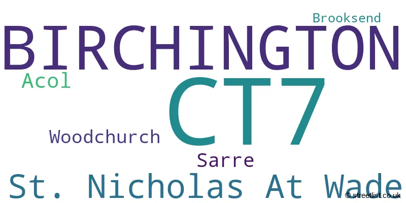
The largest settlement in the CT7 postal code is BIRCHINGTON followed by St. Nicholas At Wade, and Acol.
The postcode area has a boundary with Thames Estuary.
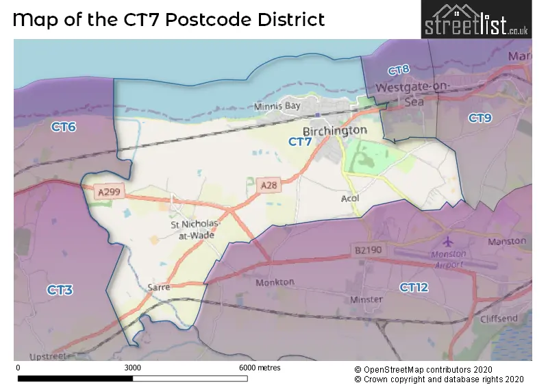
The CT7 Postcode shares a border with CT3 (Aylesham, Ash, Hersden), CT12 (RAMSGATE, Minster, Manston), CT8 (WESTGATE-ON-SEA) and CT6 (HERNE BAY, Reculver).
The CT7 postcode district in Kent, England is primarily represented by the settlement of Birchington. Other significant settlements in the district include Acol, Brooksend, Sarre, St. Nicholas At Wade, and Woodchurch. Birchington is the main post town in the district, which also falls within the county of Kent.
For the district CT7, we have data on 2 postcode sectors. Here's a breakdown: The sector CT7 0, covers Birchington and St. Nicholas At Wade in Kent. The sector CT7 9, covers Birchington in Kent.

Map of the CT7 Postcode District
Explore the CT7 postcode district by using our free interactive map.
When it comes to local government, postal geography often disregards political borders. However, for a breakdown in the CT7 District: the district mostly encompasses the Thanet District area with a total of 411 postcodes.
Weather Forecast for CT7
Press Button to Show Forecast for Birchington
| Time Period | Icon | Description | Temperature | Rain Probability | Wind |
|---|---|---|---|---|---|
| 09:00 to 12:00 | Cloudy | 10.0°C (feels like 9.0°C) | 35.00% | SE 9 mph | |
| 12:00 to 15:00 | Cloudy | 12.0°C (feels like 10.0°C) | 8.00% | ESE 9 mph | |
| 15:00 to 18:00 | Cloudy | 12.0°C (feels like 10.0°C) | 10.00% | E 11 mph | |
| 18:00 to 21:00 | Heavy rain | 11.0°C (feels like 8.0°C) | 83.00% | ENE 13 mph | |
| 21:00 to 00:00 | Heavy rain | 11.0°C (feels like 8.0°C) | 89.00% | ENE 13 mph |
Press Button to Show Forecast for Birchington
| Time Period | Icon | Description | Temperature | Rain Probability | Wind |
|---|---|---|---|---|---|
| 00:00 to 03:00 | Heavy rain | 11.0°C (feels like 9.0°C) | 92.00% | E 11 mph | |
| 03:00 to 06:00 | Heavy rain | 11.0°C (feels like 8.0°C) | 84.00% | SE 13 mph | |
| 06:00 to 09:00 | Light rain shower (day) | 10.0°C (feels like 8.0°C) | 42.00% | S 13 mph | |
| 09:00 to 12:00 | Heavy rain shower (day) | 11.0°C (feels like 8.0°C) | 58.00% | SW 18 mph | |
| 12:00 to 15:00 | Light rain shower (day) | 11.0°C (feels like 8.0°C) | 42.00% | WSW 20 mph | |
| 15:00 to 18:00 | Cloudy | 11.0°C (feels like 8.0°C) | 17.00% | WSW 16 mph | |
| 18:00 to 21:00 | Sunny day | 10.0°C (feels like 8.0°C) | 6.00% | WSW 11 mph | |
| 21:00 to 00:00 | Clear night | 8.0°C (feels like 6.0°C) | 3.00% | SW 9 mph |
Press Button to Show Forecast for Birchington
| Time Period | Icon | Description | Temperature | Rain Probability | Wind |
|---|---|---|---|---|---|
| 00:00 to 03:00 | Clear night | 7.0°C (feels like 5.0°C) | 2.00% | SW 9 mph | |
| 03:00 to 06:00 | Clear night | 7.0°C (feels like 5.0°C) | 2.00% | SSW 7 mph | |
| 06:00 to 09:00 | Sunny day | 8.0°C (feels like 7.0°C) | 1.00% | S 7 mph | |
| 09:00 to 12:00 | Cloudy | 12.0°C (feels like 10.0°C) | 4.00% | S 9 mph | |
| 12:00 to 15:00 | Partly cloudy (day) | 13.0°C (feels like 11.0°C) | 3.00% | S 11 mph | |
| 15:00 to 18:00 | Sunny day | 14.0°C (feels like 12.0°C) | 1.00% | SSE 9 mph | |
| 18:00 to 21:00 | Sunny day | 12.0°C (feels like 11.0°C) | 2.00% | SSE 7 mph | |
| 21:00 to 00:00 | Partly cloudy (night) | 9.0°C (feels like 8.0°C) | 3.00% | SE 9 mph |
Press Button to Show Forecast for Birchington
| Time Period | Icon | Description | Temperature | Rain Probability | Wind |
|---|---|---|---|---|---|
| 00:00 to 03:00 | Cloudy | 9.0°C (feels like 7.0°C) | 7.00% | ESE 9 mph | |
| 03:00 to 06:00 | Clear night | 8.0°C (feels like 7.0°C) | 5.00% | ESE 7 mph | |
| 06:00 to 09:00 | Overcast | 10.0°C (feels like 9.0°C) | 12.00% | ESE 9 mph | |
| 09:00 to 12:00 | Cloudy | 12.0°C (feels like 11.0°C) | 9.00% | SE 9 mph | |
| 12:00 to 15:00 | Cloudy | 14.0°C (feels like 12.0°C) | 10.00% | SE 9 mph | |
| 15:00 to 18:00 | Cloudy | 15.0°C (feels like 13.0°C) | 10.00% | ESE 9 mph | |
| 18:00 to 21:00 | Light rain | 13.0°C (feels like 12.0°C) | 52.00% | E 9 mph | |
| 21:00 to 00:00 | Light rain | 12.0°C (feels like 10.0°C) | 52.00% | E 9 mph |
Where is the CT7 Postcode District?
The postcode district CT7 is located in Birchington. It is situated near several towns, including Westgate-on-Sea, Ramsgate, Sandwich, Herne Bay, and Canterbury. The distance from Birchington to London is approximately 61.38 miles.
The district is within the post town of BIRCHINGTON.
The sector has postcodes within the nation of England.
The CT7 Postcode District is in the East Kent region of Kent within the South East (England).
| Postcode Sector | Delivery Office |
|---|---|
| CT7 0 | Margate Delivery Office |
| CT7 9 | Margate Delivery Office |
| C | T | 7 | - | X | X | X |
| C | T | 7 | Space | Numeric | Letter | Letter |
Current Monthly Rental Prices
| # Bedrooms | Min Price | Max Price | Avg Price |
|---|---|---|---|
| 1 | £795 | £850 | £823 |
| 2 | £900 | £1,300 | £1,038 |
| 3 | £1,350 | £1,350 | £1,350 |
| 6 | £3,000 | £3,000 | £3,000 |
Current House Prices
| # Bedrooms | Min Price | Max Price | Avg Price |
|---|---|---|---|
| £50,000 | £750,000 | £288,333 | |
| 1 | £70,000 | £195,000 | £130,643 |
| 2 | £45,000 | £750,000 | £282,362 |
| 3 | £70,000 | £695,000 | £424,156 |
| 4 | £380,000 | £1,500,000 | £639,138 |
| 5 | £475,000 | £1,300,000 | £848,124 |
| 6 | £800,000 | £1,475,000 | £1,137,500 |
| 7 | £1,500,000 | £1,500,000 | £1,500,000 |
Estate Agents who Operate in the CT7 District
| Logo | Name | Brand Name | Address | Contact Number | Total Properties |
|---|---|---|---|---|---|
 | Birchington | Wards | 15 Station Road, Birchington, Kent, CT7 9DJ | 01843 264926 | 35 |
 | Birchington | Miles & Barr | 29, Station Road, Birchington, CT7 9DJ | 01843 265226 | 30 |
 | Birchington | Oakwood Homes | 4 Station Road, Birchington, CT7 9DQ | 01843 265280 | 18 |
 | Birchington | Glenn & Co | 22 Station Road, Birchington, CT7 9DQ | 01843 264718 | 16 |
 | Canterbury | Miles & Barr Exclusive | 14 Lower Chantry Lane Canterbury CT1 1UF | 01227 532478 | 16 |
| Type of Property | 2018 Average | 2018 Sales | 2017 Average | 2017 Sales | 2016 Average | 2016 Sales | 2015 Average | 2015 Sales |
|---|---|---|---|---|---|---|---|---|
| Detached | £424,976 | 75 | £378,430 | 81 | £382,587 | 97 | £329,730 | 90 |
| Semi-Detached | £292,188 | 85 | £278,858 | 90 | £254,620 | 80 | £234,138 | 94 |
| Terraced | £237,661 | 31 | £227,244 | 48 | £201,347 | 35 | £185,143 | 42 |
| Flats | £168,590 | 49 | £161,037 | 78 | £151,702 | 89 | £132,867 | 76 |