The CT2 postcode district is a postal district located in the CT Canterbury postcode area with a population of 32,331 residents according to the 2021 England and Wales Census.
The area of the CT2 postcode district is 17.68 square miles which is 45.79 square kilometres or 11,314.85 acres.
Currently, the CT2 district has about 745 postcode units spread across 10 geographic postcode sectors.
Given that each sector allows for 400 unique postcode combinations, the district has a capacity of 4,000 postcodes. With 745 postcodes already in use, this leaves 3255 units available.
The largest settlement in the CT2 postal code is CANTERBURY followed by Sturry, and Blean.
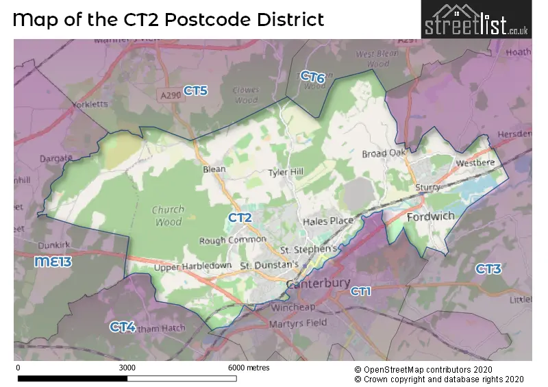
The CT2 Postcode shares a border with CT1 (CANTERBURY), CT3 (Aylesham, Ash, Hersden), CT4 (Chartham, Bridge, Barham), CT6 (HERNE BAY, Reculver), CT5 (WHITSTABLE, Chestfield, Seasalter) and ME13 (FAVERSHAM, Boughton-under-Blean, Dunkirk).
The primary settlement in the CT2 postcode district is Canterbury, which is located in the county of Kent in England. Other significant settlements in the district include Broad Oak, Fordwich, Sturry, and Westbere. The most significant post town in the district is Canterbury.
For the district CT2, we have data on 4 postcode sectors. Here's a breakdown: The sector CT2 0, covers Sturry and Broad Oak and Fordwich in Kent. The sector CT2 7, covers Canterbury in Kent. The sector CT2 8, covers Canterbury in Kent. The sector CT2 9, covers Blean and Rough Common and Tyler Hill and Upper Harbledown in Kent.

Map of the CT2 Postcode District
Explore the CT2 postcode district by using our free interactive map.
When it comes to local government, postal geography often disregards political borders. However, for a breakdown in the CT2 District: the district mostly encompasses the Canterbury District (B) (743 postcodes), and finally, the Swale District (B) area (8 postcodes).
Weather Forecast for CT2
Press Button to Show Forecast for Canterbury
| Time Period | Icon | Description | Temperature | Rain Probability | Wind |
|---|---|---|---|---|---|
| 06:00 to 09:00 | Cloudy | 6.0°C (feels like 4.0°C) | 5.00% | NE 7 mph | |
| 09:00 to 12:00 | Cloudy | 8.0°C (feels like 6.0°C) | 7.00% | ENE 7 mph | |
| 12:00 to 15:00 | Cloudy | 9.0°C (feels like 7.0°C) | 10.00% | ENE 9 mph | |
| 15:00 to 18:00 | Cloudy | 10.0°C (feels like 7.0°C) | 11.00% | E 9 mph | |
| 18:00 to 21:00 | Cloudy | 9.0°C (feels like 6.0°C) | 11.00% | E 9 mph | |
| 21:00 to 00:00 | Cloudy | 7.0°C (feels like 5.0°C) | 14.00% | E 9 mph |
Press Button to Show Forecast for Canterbury
| Time Period | Icon | Description | Temperature | Rain Probability | Wind |
|---|---|---|---|---|---|
| 00:00 to 03:00 | Light rain | 7.0°C (feels like 5.0°C) | 47.00% | E 9 mph | |
| 03:00 to 06:00 | Light rain | 7.0°C (feels like 5.0°C) | 46.00% | E 7 mph | |
| 06:00 to 09:00 | Cloudy | 8.0°C (feels like 6.0°C) | 19.00% | ESE 9 mph | |
| 09:00 to 12:00 | Cloudy | 11.0°C (feels like 9.0°C) | 15.00% | SE 9 mph | |
| 12:00 to 15:00 | Cloudy | 13.0°C (feels like 11.0°C) | 16.00% | ESE 9 mph | |
| 15:00 to 18:00 | Cloudy | 13.0°C (feels like 11.0°C) | 21.00% | E 11 mph | |
| 18:00 to 21:00 | Cloudy | 11.0°C (feels like 9.0°C) | 16.00% | E 9 mph | |
| 21:00 to 00:00 | Light rain | 11.0°C (feels like 8.0°C) | 50.00% | E 9 mph |
Press Button to Show Forecast for Canterbury
| Time Period | Icon | Description | Temperature | Rain Probability | Wind |
|---|---|---|---|---|---|
| 00:00 to 03:00 | Light rain | 11.0°C (feels like 8.0°C) | 50.00% | ESE 11 mph | |
| 03:00 to 06:00 | Cloudy | 10.0°C (feels like 8.0°C) | 20.00% | ESE 11 mph | |
| 06:00 to 09:00 | Cloudy | 10.0°C (feels like 8.0°C) | 20.00% | SE 11 mph | |
| 09:00 to 12:00 | Light rain shower (day) | 12.0°C (feels like 9.0°C) | 41.00% | S 16 mph | |
| 12:00 to 15:00 | Light rain shower (day) | 13.0°C (feels like 10.0°C) | 40.00% | SSW 16 mph | |
| 15:00 to 18:00 | Light rain shower (day) | 14.0°C (feels like 11.0°C) | 35.00% | S 16 mph | |
| 18:00 to 21:00 | Light rain shower (day) | 13.0°C (feels like 10.0°C) | 33.00% | S 11 mph | |
| 21:00 to 00:00 | Clear night | 10.0°C (feels like 8.0°C) | 7.00% | SSW 9 mph |
Where is the CT2 Postcode District?
The postcode district CT2 is located in Canterbury. It is in close proximity to several nearby towns, including Whitstable (3.04 miles to the North), Herne Bay (4.65 miles to the North East), Faversham (6.12 miles to the West), Rochester (11.96 miles to the North West), and Sandwich (12.14 miles to the East). Furthermore, Canterbury is situated approximately 53.39 miles away from the center of London.
The district is within the post town of CANTERBURY.
The sector has postcodes within the nation of England.
The CT2 Postcode District is covers the following regions.
- East Kent - Kent - South East (England)
- Kent Thames Gateway - Kent - South East (England)
Postcode Sectors within the CT2 District
| Postcode Sector | Delivery Office |
|---|---|
| CT2 0 | Canterbury Delivery Office |
| CT2 7 | Canterbury Delivery Office |
| CT2 8 | Canterbury Delivery Office |
| CT2 9 | Canterbury Delivery Office |
| C | T | 2 | - | X | X | X |
| C | T | 2 | Space | Numeric | Letter | Letter |
Current Monthly Rental Prices
| # Bedrooms | Min Price | Max Price | Avg Price |
|---|---|---|---|
| £755 | £775 | £765 | |
| 1 | £310 | £900 | £563 |
| 2 | £575 | £3,250 | £1,572 |
| 3 | £433 | £1,650 | £1,243 |
| 4 | £300 | £2,500 | £1,228 |
| 5 | £395 | £4,000 | £1,770 |
| 6 | £475 | £2,964 | £1,936 |
| 7 | £550 | £3,852 | £2,201 |
| 17 | £4,583 | £4,583 | £4,583 |
Current House Prices
| # Bedrooms | Min Price | Max Price | Avg Price |
|---|---|---|---|
| £18,000 | £850,000 | £317,667 | |
| 1 | £64,000 | £275,000 | £147,866 |
| 2 | £105,500 | £800,000 | £263,979 |
| 3 | £190,000 | £850,000 | £383,392 |
| 4 | £175,000 | £2,000,000 | £552,181 |
| 5 | £275,000 | £1,400,000 | £580,000 |
| 6 | £525,000 | £2,200,000 | £983,571 |
| 7 | £2,500,000 | £3,000,000 | £2,750,000 |
| 8 | £995,000 | £995,000 | £995,000 |
| 19 | £1,700,000 | £1,700,000 | £1,700,000 |
Estate Agents who Operate in the CT2 District
| Logo | Name | Brand Name | Address | Contact Number | Total Properties |
|---|---|---|---|---|---|
 | Canterbury | Miles & Barr | 14 Lower Chantry Lane Canterbury CT1 1UF | 01227 532461 | 41 |
 | Canterbury | Varsity Canterbury | 39 Palace Street Canterbury CT1 2DZ | 01227 467676 | 25 |
 | Canterbury | Your Move | 3 St. Margarets Street, Canterbury, CT1 2TP | 01227 202344 | 16 |
 | London | OpenRent | 39 Great Windmill Street London W1D 7LX | 020 3322 3265 | 14 |
 | Canterbury | Bairstow Eves | 32a St Margarets Street, Canterbury, Kent, CT1 2TG | 01227 203655 | 14 |
| Type of Property | 2018 Average | 2018 Sales | 2017 Average | 2017 Sales | 2016 Average | 2016 Sales | 2015 Average | 2015 Sales |
|---|---|---|---|---|---|---|---|---|
| Detached | £495,486 | 69 | £468,164 | 84 | £461,630 | 75 | £416,209 | 91 |
| Semi-Detached | £303,905 | 123 | £285,866 | 131 | £282,076 | 132 | £251,054 | 145 |
| Terraced | £279,895 | 110 | £288,719 | 114 | £280,677 | 114 | £255,356 | 137 |
| Flats | £219,522 | 62 | £204,817 | 56 | £190,840 | 47 | £185,083 | 81 |