The CT5 postcode district is a postal district located in the CT Canterbury postcode area with a population of 33,165 residents according to the 2021 England and Wales Census.
The area of the CT5 postcode district is 11.81 square miles which is 30.60 square kilometres or 7,561.17 acres.
Currently, the CT5 district has about 964 postcode units spread across 4 geographic postcode sectors.
Given that each sector allows for 400 unique postcode combinations, the district has a capacity of 1,600 postcodes. With 964 postcodes already in use, this leaves 636 units available.
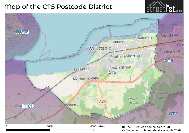
The largest settlement in the CT5 postal code is WHITSTABLE followed by Chestfield, and Seasalter.
The postcode area has a boundary with Thames Estuary.
The CT5 Postcode shares a border with CT2 (CANTERBURY, Sturry, Blean), CT6 (HERNE BAY, Reculver) and ME13 (FAVERSHAM, Boughton-under-Blean, Dunkirk).
In the CT5 postcode district, the primary settlement is Whitstable, which is located in the county of Kent in England. Additionally, there are other significant settlements in the district, including Chestfield, Seasalter, and Yorkletts. The most significant post town in the district is also Whitstable.
For the district CT5, we have data on 5 postcode sectors. Here's a breakdown: The sector CT5 1, covers Whitstable in Kent. The sector CT5 2, covers Whitstable in Kent. The sector CT5 3, covers Whitstable and Chestfield in Kent. The sector CT5 4, covers Whitstable and Seasalter in Kent. The sector CT5 9 is non-geographic. It's often designated for PO Boxes, large organisations, or special services.


Map of the CT5 Postcode District
Explore the CT5 postcode district by using our free interactive map.
When it comes to local government, postal geography often disregards political borders. However, for a breakdown in the CT5 District: the district mostly encompasses the Canterbury District (B) area with a total of 973 postcodes.
Weather Forecast for CT5
Press Button to Show Forecast for Whitstable
| Time Period | Icon | Description | Temperature | Rain Probability | Wind |
|---|---|---|---|---|---|
| 12:00 to 15:00 | Light rain | 13.0°C (feels like 11.0°C) | 49.00% | ENE 9 mph | |
| 15:00 to 18:00 | Cloudy | 13.0°C (feels like 11.0°C) | 11.00% | E 11 mph | |
| 18:00 to 21:00 | Light rain | 11.0°C (feels like 9.0°C) | 58.00% | ENE 11 mph | |
| 21:00 to 00:00 | Heavy rain | 10.0°C (feels like 8.0°C) | 89.00% | ENE 13 mph |
Press Button to Show Forecast for Whitstable
| Time Period | Icon | Description | Temperature | Rain Probability | Wind |
|---|---|---|---|---|---|
| 00:00 to 03:00 | Heavy rain | 11.0°C (feels like 9.0°C) | 92.00% | ENE 9 mph | |
| 03:00 to 06:00 | Heavy rain | 11.0°C (feels like 9.0°C) | 85.00% | SE 11 mph | |
| 06:00 to 09:00 | Light rain shower (day) | 10.0°C (feels like 8.0°C) | 48.00% | SW 13 mph | |
| 09:00 to 12:00 | Light rain shower (day) | 11.0°C (feels like 8.0°C) | 46.00% | SW 16 mph | |
| 12:00 to 15:00 | Heavy rain shower (day) | 11.0°C (feels like 8.0°C) | 62.00% | W 18 mph | |
| 15:00 to 18:00 | Cloudy | 11.0°C (feels like 8.0°C) | 18.00% | WSW 16 mph | |
| 18:00 to 21:00 | Sunny day | 11.0°C (feels like 9.0°C) | 7.00% | WSW 9 mph | |
| 21:00 to 00:00 | Clear night | 8.0°C (feels like 6.0°C) | 3.00% | SW 9 mph |
Press Button to Show Forecast for Whitstable
| Time Period | Icon | Description | Temperature | Rain Probability | Wind |
|---|---|---|---|---|---|
| 00:00 to 03:00 | Clear night | 7.0°C (feels like 5.0°C) | 3.00% | SW 7 mph | |
| 03:00 to 06:00 | Clear night | 6.0°C (feels like 4.0°C) | 2.00% | SSW 7 mph | |
| 06:00 to 09:00 | Sunny day | 8.0°C (feels like 6.0°C) | 1.00% | S 7 mph | |
| 09:00 to 12:00 | Cloudy | 12.0°C (feels like 11.0°C) | 5.00% | S 9 mph | |
| 12:00 to 15:00 | Cloudy | 14.0°C (feels like 12.0°C) | 8.00% | S 11 mph | |
| 15:00 to 18:00 | Sunny day | 14.0°C (feels like 12.0°C) | 3.00% | S 9 mph | |
| 18:00 to 21:00 | Sunny day | 13.0°C (feels like 12.0°C) | 2.00% | SSE 7 mph | |
| 21:00 to 00:00 | Cloudy | 9.0°C (feels like 8.0°C) | 5.00% | SE 7 mph |
Press Button to Show Forecast for Whitstable
| Time Period | Icon | Description | Temperature | Rain Probability | Wind |
|---|---|---|---|---|---|
| 00:00 to 03:00 | Cloudy | 9.0°C (feels like 7.0°C) | 6.00% | SE 7 mph | |
| 03:00 to 06:00 | Partly cloudy (night) | 8.0°C (feels like 7.0°C) | 5.00% | SE 7 mph | |
| 06:00 to 09:00 | Cloudy | 10.0°C (feels like 9.0°C) | 9.00% | SE 7 mph | |
| 09:00 to 12:00 | Overcast | 13.0°C (feels like 12.0°C) | 13.00% | SE 9 mph | |
| 12:00 to 15:00 | Cloudy | 15.0°C (feels like 14.0°C) | 11.00% | SE 9 mph | |
| 15:00 to 18:00 | Cloudy | 16.0°C (feels like 14.0°C) | 12.00% | ESE 9 mph | |
| 18:00 to 21:00 | Light rain | 14.0°C (feels like 13.0°C) | 52.00% | ESE 9 mph | |
| 21:00 to 00:00 | Light rain | 12.0°C (feels like 11.0°C) | 51.00% | ESE 7 mph |
Where is the CT5 Postcode District?
The postcode district for CT5 is located in Whitstable. Whitstable is a district town situated in close proximity to several nearby towns. To the east, there is Herne Bay, which is approximately 4.3 miles away. In the west direction, Faversham is situated about 4.9 miles away from Whitstable. To the southeast, there is Canterbury, which is approximately 5.2 miles away. Finally, in the northwest direction, there is Rochester, which is situated about 9.2 miles away from Whitstable. Additionally, the distance from Whitstable to the center of London is approximately 51.4 miles.
The district is within the post town of WHITSTABLE.
The sector has postcodes within the nation of England.
The CT5 Postcode District is in the East Kent region of Kent within the South East (England).
| Postcode Sector | Delivery Office |
|---|---|
| CT5 1 | Whitstable Delivery Office |
| CT5 2 | Whitstable Delivery Office |
| CT5 3 | Whitstable Delivery Office |
| CT5 4 | Whitstable Delivery Office |
| C | T | 5 | - | X | X | X |
| C | T | 5 | Space | Numeric | Letter | Letter |
Tourist Attractions within the Postcode Area
We found 1 visitor attractions within the CT5 postcode area
| Whitstable Museum and Gallery |
|---|
| Museums & Art Galleries |
| Museum and / or Art Gallery |
| View Whitstable Museum and Gallery on Google Maps |
Current Monthly Rental Prices
| # Bedrooms | Min Price | Max Price | Avg Price |
|---|---|---|---|
| 1 | £715 | £950 | £805 |
| 2 | £750 | £1,850 | £1,220 |
| 3 | £1,300 | £1,800 | £1,535 |
| 4 | £1,600 | £1,600 | £1,600 |
| 5 | £2,495 | £2,750 | £2,665 |
Current House Prices
| # Bedrooms | Min Price | Max Price | Avg Price |
|---|---|---|---|
| £5,000 | £725,000 | £152,330 | |
| 1 | £50,000 | £275,000 | £199,330 |
| 2 | £28,995 | £845,000 | £323,375 |
| 3 | £44,995 | £1,395,000 | £487,399 |
| 4 | £280,500 | £1,395,000 | £708,555 |
| 5 | £400,000 | £3,000,000 | £942,311 |
| 6 | £750,000 | £1,500,000 | £1,224,167 |
| 8 | £895,000 | £895,000 | £895,000 |
| 10 | £895,000 | £895,000 | £895,000 |
Estate Agents who Operate in the CT5 District
| Logo | Name | Brand Name | Address | Contact Number | Total Properties |
|---|---|---|---|---|---|
 | Whitstable | Christopher Hodgson | 95-97 Tankerton Road, Whitstable, CT5 2AJ | 01227 203947 | 71 |
 | Tankerton | Kent Estate Agencies | 94-100 Tankerton Road, Whitstable, CT5 2AH | 01227 204517 | 62 |
 | Whitstable | Miles & Barr | 87 High Street Whitstable CT5 1AY | 01227 204287 | 55 |
 | Whitstable | Wards | 72 High Street, Whitstable, Kent, CT5 1AZ | 01227 532513 | 54 |
 | Whitstable | Woodward & Bishopp | 112 High Street, Whitstable, CT5 1AZ | 01227 538853 | 44 |
| Type of Property | 2018 Average | 2018 Sales | 2017 Average | 2017 Sales | 2016 Average | 2016 Sales | 2015 Average | 2015 Sales |
|---|---|---|---|---|---|---|---|---|
| Detached | £483,728 | 222 | £483,031 | 215 | £453,537 | 254 | £414,493 | 280 |
| Semi-Detached | £325,253 | 155 | £320,039 | 187 | £299,268 | 190 | £276,532 | 227 |
| Terraced | £369,203 | 110 | £341,185 | 126 | £312,095 | 132 | £301,895 | 147 |
| Flats | £245,018 | 93 | £224,108 | 87 | £201,251 | 103 | £174,044 | 170 |