The CT5 3 postcode sector is within the county of Kent.
Did you know? According to the 2021 Census, the CT5 3 postcode sector is home to a bustling 7,563 residents!
Given that each sector allows for 400 unique postcode combinations. Letters C, I, K, M, O and V are not allowed in the last two letters of a postcode. With 227 postcodes already in use, this leaves 173 units available.
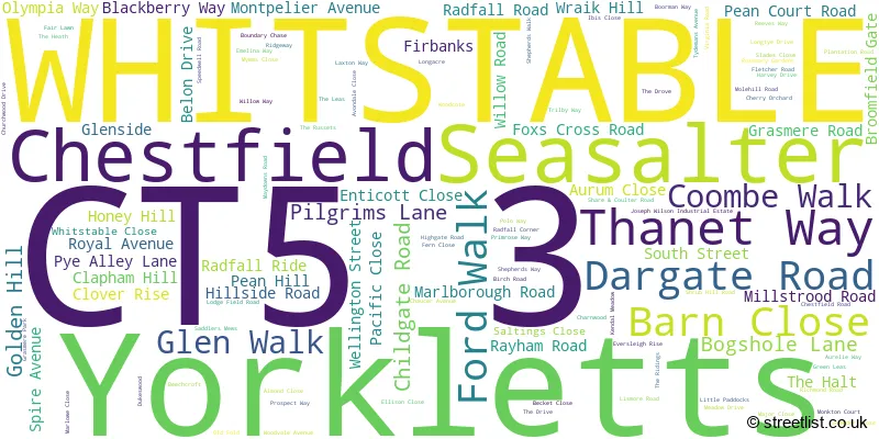
The largest settlement in the CT5 3 postal code is WHITSTABLE followed by Chestfield, and Yorkletts.
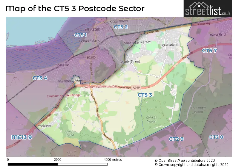
The CT5 3 Postcode shares a border with ME13 9 (Boughton-under-Blean, Dunkirk, Selling), CT2 9 (Blean, Rough Common, Tyler Hill), CT5 1 (WHITSTABLE), CT5 2 (WHITSTABLE), CT5 4 (WHITSTABLE, Seasalter) and CT6 7 (HERNE BAY, Herne Common).
The sector is within the post town of WHITSTABLE.
CT5 3 is a postcode sector within the CT5 postcode district which is within the CT Canterbury postcode area.
The Royal Mail delivery office for the CT5 3 postal sector is the Whitstable Delivery Office.
The area of the CT5 3 postcode sector is 7.01 square miles which is 18.15 square kilometres or 4,485.97 square acres.

Map of the CT5 3 Postcode Sector
Explore the CT5 3 postcode sector by using our free interactive map.
| C | T | 5 | - | 3 | X | X |
| C | T | 5 | Space | 3 | Letter | Letter |
Official List of Streets
Chestfield (49 Streets)
WHITSTABLE (63 Streets)
Yorkletts (7 Streets)
Seasalter (1 Streets)
Unofficial Streets or Alternative Spellings
WHITSTABLE
CHURCH STREET FAVOURITE ROAD FOXGROVE ROAD HERNE BAY ROAD SHEPPEY VIEWBlean
HONEY HILLSeasalter
SEASALTER LANEHernhill
HIGHSTREET ROADWeather Forecast for CT5 3
Press Button to Show Forecast for Whitstable
| Time Period | Icon | Description | Temperature | Rain Probability | Wind |
|---|---|---|---|---|---|
| 06:00 to 09:00 | Heavy rain | 8.0°C (feels like 6.0°C) | 74.00% | E 11 mph | |
| 09:00 to 12:00 | Cloudy | 10.0°C (feels like 9.0°C) | 9.00% | E 9 mph | |
| 12:00 to 15:00 | Light rain | 13.0°C (feels like 11.0°C) | 49.00% | ENE 9 mph | |
| 15:00 to 18:00 | Cloudy | 13.0°C (feels like 11.0°C) | 11.00% | E 11 mph | |
| 18:00 to 21:00 | Light rain | 11.0°C (feels like 9.0°C) | 58.00% | ENE 11 mph | |
| 21:00 to 00:00 | Heavy rain | 10.0°C (feels like 8.0°C) | 89.00% | ENE 13 mph |
Press Button to Show Forecast for Whitstable
| Time Period | Icon | Description | Temperature | Rain Probability | Wind |
|---|---|---|---|---|---|
| 00:00 to 03:00 | Heavy rain | 11.0°C (feels like 9.0°C) | 92.00% | ENE 9 mph | |
| 03:00 to 06:00 | Heavy rain | 11.0°C (feels like 9.0°C) | 85.00% | SE 11 mph | |
| 06:00 to 09:00 | Light rain shower (day) | 10.0°C (feels like 8.0°C) | 48.00% | SW 13 mph | |
| 09:00 to 12:00 | Light rain shower (day) | 11.0°C (feels like 8.0°C) | 46.00% | SW 16 mph | |
| 12:00 to 15:00 | Heavy rain shower (day) | 11.0°C (feels like 8.0°C) | 62.00% | W 18 mph | |
| 15:00 to 18:00 | Cloudy | 11.0°C (feels like 8.0°C) | 18.00% | WSW 16 mph | |
| 18:00 to 21:00 | Sunny day | 11.0°C (feels like 9.0°C) | 7.00% | WSW 9 mph | |
| 21:00 to 00:00 | Clear night | 8.0°C (feels like 6.0°C) | 3.00% | SW 9 mph |
Press Button to Show Forecast for Whitstable
| Time Period | Icon | Description | Temperature | Rain Probability | Wind |
|---|---|---|---|---|---|
| 00:00 to 03:00 | Clear night | 7.0°C (feels like 5.0°C) | 3.00% | SW 7 mph | |
| 03:00 to 06:00 | Clear night | 6.0°C (feels like 4.0°C) | 2.00% | SSW 7 mph | |
| 06:00 to 09:00 | Sunny day | 8.0°C (feels like 6.0°C) | 1.00% | S 7 mph | |
| 09:00 to 12:00 | Cloudy | 12.0°C (feels like 11.0°C) | 5.00% | S 9 mph | |
| 12:00 to 15:00 | Cloudy | 14.0°C (feels like 12.0°C) | 8.00% | S 11 mph | |
| 15:00 to 18:00 | Sunny day | 14.0°C (feels like 12.0°C) | 3.00% | S 9 mph | |
| 18:00 to 21:00 | Sunny day | 13.0°C (feels like 12.0°C) | 2.00% | SSE 7 mph | |
| 21:00 to 00:00 | Cloudy | 9.0°C (feels like 8.0°C) | 5.00% | SE 7 mph |
Press Button to Show Forecast for Whitstable
| Time Period | Icon | Description | Temperature | Rain Probability | Wind |
|---|---|---|---|---|---|
| 00:00 to 03:00 | Cloudy | 9.0°C (feels like 7.0°C) | 6.00% | SE 7 mph | |
| 03:00 to 06:00 | Partly cloudy (night) | 8.0°C (feels like 7.0°C) | 5.00% | SE 7 mph | |
| 06:00 to 09:00 | Cloudy | 10.0°C (feels like 9.0°C) | 9.00% | SE 7 mph | |
| 09:00 to 12:00 | Overcast | 13.0°C (feels like 12.0°C) | 13.00% | SE 9 mph | |
| 12:00 to 15:00 | Cloudy | 15.0°C (feels like 14.0°C) | 11.00% | SE 9 mph | |
| 15:00 to 18:00 | Cloudy | 16.0°C (feels like 14.0°C) | 12.00% | ESE 9 mph | |
| 18:00 to 21:00 | Light rain | 14.0°C (feels like 13.0°C) | 52.00% | ESE 9 mph | |
| 21:00 to 00:00 | Light rain | 12.0°C (feels like 11.0°C) | 51.00% | ESE 7 mph |
House Prices in the CT5 3 Postcode Sector
| Type of Property | 2018 Average | 2018 Sales | 2017 Average | 2017 Sales | 2016 Average | 2016 Sales | 2015 Average | 2015 Sales |
|---|---|---|---|---|---|---|---|---|
| Detached | £498,784 | 66 | £487,816 | 71 | £438,981 | 87 | £425,652 | 89 |
| Semi-Detached | £304,646 | 27 | £297,204 | 23 | £291,489 | 28 | £263,642 | 26 |
| Terraced | £278,324 | 17 | £230,541 | 11 | £218,467 | 17 | £202,806 | 9 |
| Flats | £187,594 | 16 | £183,976 | 21 | £185,526 | 19 | £147,445 | 73 |
Important Postcodes CT5 3 in the Postcode Sector
CT5 3QT is the postcode for Brook House, John Wilson Business Park, Harvey Drive
CT5 3QU is the postcode for Whitstable Medical Practice, Reeves Way
CT5 3QZ is the postcode for Kent County Council, Clover House, Harvey Drive, John Wilson Business Park
CT5 3SE is the postcode for Estuary View Medical Centre, 25 Estuary View Business Park, Boorman Way
CT5 3SS is the postcode for Brook House, Reeves Way, and K C C Social Services, Brook House, Reeves Way
| The CT5 3 Sector is within these Local Authorities |
|
|---|---|
| The CT5 3 Sector is within these Counties |
|
| The CT5 3 Sector is within these Water Company Areas |
|