The CT6 7 postcode sector is within the county of Kent.
Did you know? According to the 2021 Census, the CT6 7 postcode sector is home to a bustling 12,578 residents!
Given that each sector allows for 400 unique postcode combinations. Letters C, I, K, M, O and V are not allowed in the last two letters of a postcode. With 277 postcodes already in use, this leaves 123 units available.
The largest settlements in the CT6 7 postal code are HERNE BAY and Herne Common.
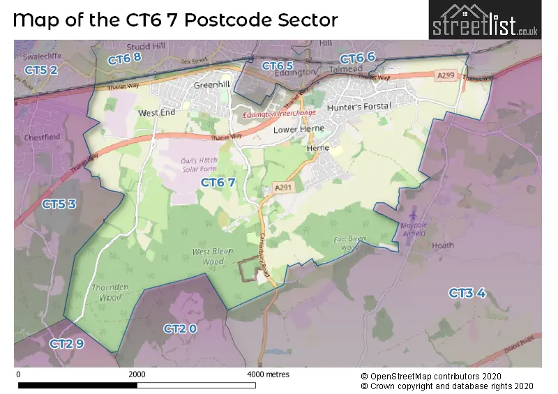
The CT6 7 Postcode shares a border with CT2 0 (Sturry, Broad Oak, Westbere), CT2 9 (Blean, Rough Common, Tyler Hill), CT3 4 (Hersden, Hoath, Upstreet), CT5 2 (WHITSTABLE), CT5 3 (WHITSTABLE, Chestfield, Yorkletts), CT6 5 (HERNE BAY), CT6 6 (HERNE BAY, Reculver) and CT6 8 (HERNE BAY).
The sector is within the post town of HERNE BAY.
CT6 7 is a postcode sector within the CT6 postcode district which is within the CT Canterbury postcode area.
The Royal Mail delivery office for the CT6 7 postal sector is the Herne Bay Delivery Office.
The area of the CT6 7 postcode sector is 7.81 square miles which is 20.22 square kilometres or 4,997.70 square acres.

Map of the CT6 7 Postcode Sector
Explore the CT6 7 postcode sector by using our free interactive map.
| C | T | 6 | - | 7 | X | X |
| C | T | 6 | Space | 7 | Letter | Letter |
Official List of Streets
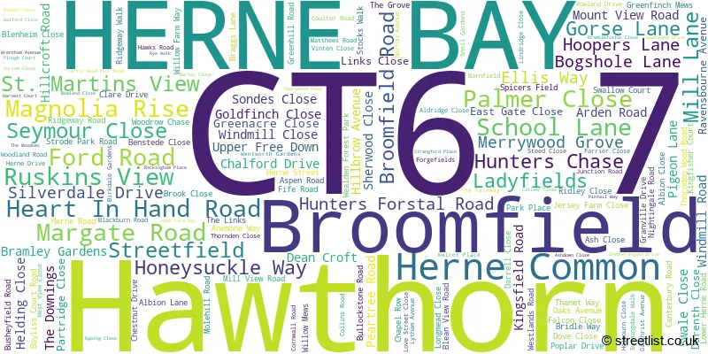
HERNE BAY (148 Streets)
Herne Common (3 Streets)
Hawthorn (1 Streets)
Broomfield (1 Streets)
Unofficial Streets or Alternative Spellings
HERNE BAY
EDDINGTON LANE EIDER CLOSE GREENHILL BRIDGE ROAD POCHARD CRESCENT SWEECHBRIDGE ROAD WESTBROOK LANE WYE GREEN AMBROSE AVENUE BANCORD AVENUE BAWCOMB CLOSE BLEANVIEW BOWES DRIVE BRAID DRIVE CHAPMAN ROAD COLT PLACE CONDOR CLOSE COOPER DRIVE CURTIS WOOD ROAD DRIVERS CLOSE EDDINGTON JUNCTION GREEN LANE GREENHILL ROAD (EAST) GREENHILL ROAD (WEST) HEATH GROVE HERNE RELIEF ROAD HOLNESS ROAD HUNTER AVENUE LAVER ROAD LOVELL CLOSE MAYSTREET MILL COURT CLOSE NEW ROAD OWLS HATCH ROAD OWLS HATCH ROAD (NORTH) PARKLAND ROAD RANDALL WAY REID CRESCENT REYNOLDS DRIVE ROBINSON ROAD RYDER COURT SIDNEY GROVE SINCLAIR STREET ST. MARTINS VIEW STEEL CLOSE TELFORD COURT THE FAIRWAY PATH WYATT CRESCENTHoath
HICKS FORSTAL ROADChestfield
MOLEHILL ROAD THANET WAYAltira Business Park
THE BOULEVARDWeather Forecast for CT6 7
Press Button to Show Forecast for Herne Bay
| Time Period | Icon | Description | Temperature | Rain Probability | Wind |
|---|---|---|---|---|---|
| 09:00 to 12:00 | Light rain shower (day) | 11.0°C (feels like 9.0°C) | 36.00% | ESE 9 mph | |
| 12:00 to 15:00 | Cloudy | 13.0°C (feels like 11.0°C) | 34.00% | ESE 9 mph | |
| 15:00 to 18:00 | Cloudy | 13.0°C (feels like 10.0°C) | 10.00% | E 11 mph | |
| 18:00 to 21:00 | Heavy rain | 11.0°C (feels like 9.0°C) | 83.00% | ENE 11 mph | |
| 21:00 to 00:00 | Heavy rain | 11.0°C (feels like 8.0°C) | 89.00% | ENE 13 mph |
Press Button to Show Forecast for Herne Bay
| Time Period | Icon | Description | Temperature | Rain Probability | Wind |
|---|---|---|---|---|---|
| 00:00 to 03:00 | Heavy rain | 11.0°C (feels like 9.0°C) | 92.00% | E 11 mph | |
| 03:00 to 06:00 | Heavy rain | 11.0°C (feels like 9.0°C) | 84.00% | SE 11 mph | |
| 06:00 to 09:00 | Light rain shower (day) | 11.0°C (feels like 8.0°C) | 42.00% | S 13 mph | |
| 09:00 to 12:00 | Light rain shower (day) | 11.0°C (feels like 8.0°C) | 42.00% | SW 18 mph | |
| 12:00 to 15:00 | Light rain shower (day) | 11.0°C (feels like 8.0°C) | 43.00% | WSW 20 mph | |
| 15:00 to 18:00 | Cloudy | 11.0°C (feels like 8.0°C) | 17.00% | WSW 18 mph | |
| 18:00 to 21:00 | Sunny day | 11.0°C (feels like 8.0°C) | 6.00% | WSW 11 mph | |
| 21:00 to 00:00 | Clear night | 8.0°C (feels like 6.0°C) | 3.00% | SW 9 mph |
Press Button to Show Forecast for Herne Bay
| Time Period | Icon | Description | Temperature | Rain Probability | Wind |
|---|---|---|---|---|---|
| 00:00 to 03:00 | Clear night | 8.0°C (feels like 5.0°C) | 2.00% | SW 9 mph | |
| 03:00 to 06:00 | Clear night | 7.0°C (feels like 5.0°C) | 2.00% | SSW 7 mph | |
| 06:00 to 09:00 | Sunny day | 9.0°C (feels like 7.0°C) | 1.00% | S 7 mph | |
| 09:00 to 12:00 | Cloudy | 12.0°C (feels like 10.0°C) | 4.00% | S 9 mph | |
| 12:00 to 15:00 | Partly cloudy (day) | 14.0°C (feels like 11.0°C) | 3.00% | S 11 mph | |
| 15:00 to 18:00 | Sunny day | 14.0°C (feels like 12.0°C) | 1.00% | SSE 9 mph | |
| 18:00 to 21:00 | Partly cloudy (day) | 12.0°C (feels like 11.0°C) | 2.00% | SSE 7 mph | |
| 21:00 to 00:00 | Partly cloudy (night) | 10.0°C (feels like 8.0°C) | 3.00% | SE 7 mph |
Press Button to Show Forecast for Herne Bay
| Time Period | Icon | Description | Temperature | Rain Probability | Wind |
|---|---|---|---|---|---|
| 00:00 to 03:00 | Cloudy | 9.0°C (feels like 8.0°C) | 7.00% | ESE 9 mph | |
| 03:00 to 06:00 | Clear night | 9.0°C (feels like 7.0°C) | 5.00% | ESE 7 mph | |
| 06:00 to 09:00 | Overcast | 11.0°C (feels like 9.0°C) | 12.00% | ESE 7 mph | |
| 09:00 to 12:00 | Cloudy | 13.0°C (feels like 11.0°C) | 9.00% | SE 9 mph | |
| 12:00 to 15:00 | Cloudy | 14.0°C (feels like 13.0°C) | 10.00% | SE 9 mph | |
| 15:00 to 18:00 | Cloudy | 15.0°C (feels like 14.0°C) | 10.00% | ESE 9 mph | |
| 18:00 to 21:00 | Light rain | 13.0°C (feels like 12.0°C) | 52.00% | E 9 mph | |
| 21:00 to 00:00 | Light rain | 12.0°C (feels like 11.0°C) | 52.00% | ESE 9 mph |
Schools and Places of Education Within the CT6 7 Postcode Sector
Herne Bay High School
Academy converter
Bullockstone Road, Herne Bay, Kent, CT6 7NS
Head: Mr Jon Boyes
Ofsted Rating: Good
Inspection: 2022-06-15 (682 days ago)
Website: Visit Herne Bay High School Website
Phone: 01227361221
Number of Pupils: 1586
Herne Church of England Infant and Nursery School
Voluntary controlled school
Palmer Close, Herne Bay, Kent, CT6 7AH
Head: Mrs E Thomas-Friend
Ofsted Rating: Outstanding
Inspection: 2021-09-29 (941 days ago)
Website: Visit Herne Church of England Infant and Nursery School Website
Phone: 01227740793
Number of Pupils: 316
Herne Church of England Junior School
Voluntary aided school
School Lane, Herne Bay, Kent, CT6 7AL
Head: Mr Mal Saunders
Ofsted Rating: Outstanding
Inspection: 2023-11-01 (178 days ago)
Website: Visit Herne Church of England Junior School Website
Phone: 01227374069
Number of Pupils: 360
House Prices in the CT6 7 Postcode Sector
| Type of Property | 2018 Average | 2018 Sales | 2017 Average | 2017 Sales | 2016 Average | 2016 Sales | 2015 Average | 2015 Sales |
|---|---|---|---|---|---|---|---|---|
| Detached | £381,475 | 81 | £350,647 | 61 | £352,408 | 82 | £311,131 | 100 |
| Semi-Detached | £272,029 | 87 | £257,536 | 84 | £248,230 | 82 | £221,987 | 82 |
| Terraced | £245,865 | 37 | £229,766 | 47 | £223,162 | 43 | £182,006 | 35 |
| Flats | £150,411 | 9 | £215,658 | 6 | £125,188 | 8 | £150,199 | 10 |
Important Postcodes CT6 7 in the Postcode Sector
CT6 7AH is the postcode for HERNE CHURCH OF ENGLAND CONTROLLED INFANT SCHOOL, PALMER CLOSE, HERNE, Herne Church Of England Controlled Infant School, Palmer Close, and Herne C of E Infant School, Palmer Close
CT6 7AL is the postcode for Herne Junior School, School Lane, HERNE CHURCH OF ENGLAND JUNIOR SCHOOL, SCHOOL LANE, HERNE, Herne Church Of England Junior School, School Lane, and ST AUGUSTINES BLOCK, Herne Junior School, School Lane
CT6 7LY is the postcode for 38 Broomfield Road
CT6 7NS is the postcode for BLOCK B, Herne Bay High School, Bullockstone Road, MUSIC BLOCK, Herne Bay High School, Bullockstone Road, BLOCKS S & E, Herne Bay High School, Bullockstone Road, BLOCK C, Herne Bay High School, Bullockstone Road, BLOCKS H, L & NOF, Herne Bay High School, Bullockstone Road, BLOCK M, Herne Bay High School, Bullockstone Road, Herne Bay High School, Bullockstone Road, BLOCK O, Herne Bay High School, Bullockstone Road, BLOCK N, Herne Bay High School, Bullockstone Road, BLOCK V, Herne Bay High School, Bullockstone Road, and HOSPITALITY & CATERING, Herne Bay High School, Bullockstone Road
CT6 7RS is the postcode for Briary Primary School, Greenhill Road
| The CT6 7 Sector is within these Local Authorities |
|
|---|---|
| The CT6 7 Sector is within these Counties |
|
| The CT6 7 Sector is within these Water Company Areas |
|
Tourist Attractions within the CT6 7 Postcode Area
We found 1 visitor attractions within the CT6 postcode area
| Wildwood |
|---|
| Wildlife |
| Nature Reserve / Wetlands / Wildlife Trips |
| View Wildwood on Google Maps |