The CT5 2 postcode sector is within the county of Kent.
Did you know? According to the 2021 Census, the CT5 2 postcode sector is home to a bustling 7,874 residents!
Given that each sector allows for 400 unique postcode combinations. Letters C, I, K, M, O and V are not allowed in the last two letters of a postcode. With 223 postcodes already in use, this leaves 177 units available.
The CT5 2 postal code covers the settlement of WHITSTABLE.
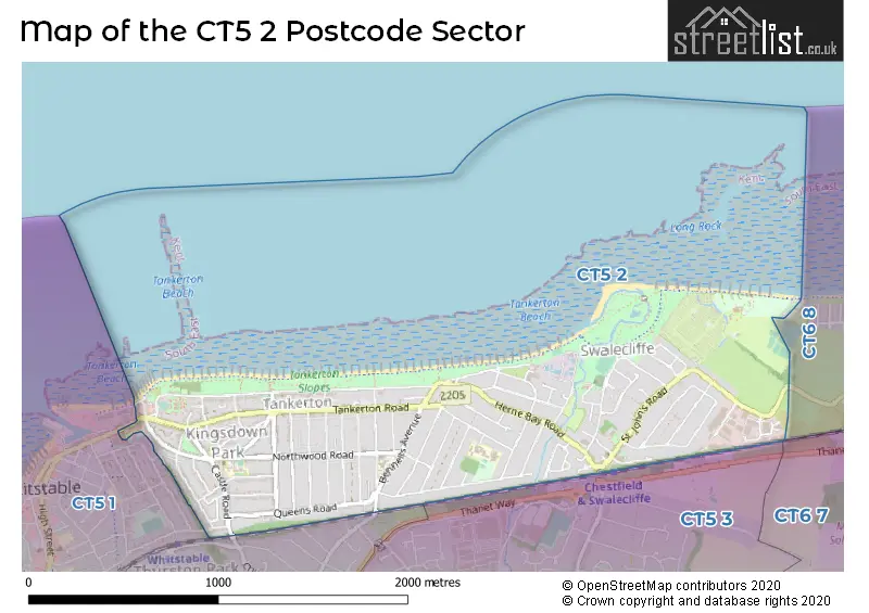
The CT5 2 Postcode shares a border with CT5 1 (WHITSTABLE), CT5 3 (WHITSTABLE, Chestfield, Yorkletts), CT6 7 (HERNE BAY, Herne Common) and CT6 8 (HERNE BAY).
The sector is within the post town of WHITSTABLE.
CT5 2 is a postcode sector within the CT5 postcode district which is within the CT Canterbury postcode area.
The Royal Mail delivery office for the CT5 2 postal sector is the Whitstable Delivery Office.
The area of the CT5 2 postcode sector is 1.03 square miles which is 2.65 square kilometres or 656.03 square acres.

Map of the CT5 2 Postcode Sector
Explore the CT5 2 postcode sector by using our free interactive map.
| C | T | 5 | - | 2 | X | X |
| C | T | 5 | Space | 2 | Letter | Letter |
Official List of Streets
WHITSTABLE (77 Streets)
Unofficial Streets or Alternative Spellings
Weather Forecast for CT5 2
Press Button to Show Forecast for Whitstable
| Time Period | Icon | Description | Temperature | Rain Probability | Wind |
|---|---|---|---|---|---|
| 00:00 to 03:00 | Cloudy | 15.0°C (feels like 14.0°C) | 4.00% | E 9 mph | |
| 03:00 to 06:00 | Cloudy | 14.0°C (feels like 12.0°C) | 4.00% | ESE 9 mph | |
| 06:00 to 09:00 | Cloudy | 15.0°C (feels like 14.0°C) | 4.00% | ESE 7 mph | |
| 09:00 to 12:00 | Cloudy | 20.0°C (feels like 19.0°C) | 4.00% | ESE 9 mph | |
| 12:00 to 15:00 | Partly cloudy (day) | 23.0°C (feels like 21.0°C) | 0.00% | E 9 mph | |
| 15:00 to 18:00 | Partly cloudy (day) | 23.0°C (feels like 22.0°C) | 1.00% | ESE 9 mph | |
| 18:00 to 21:00 | Cloudy | 21.0°C (feels like 20.0°C) | 4.00% | SSE 7 mph | |
| 21:00 to 00:00 | Cloudy | 16.0°C (feels like 15.0°C) | 7.00% | SSW 7 mph |
Press Button to Show Forecast for Whitstable
| Time Period | Icon | Description | Temperature | Rain Probability | Wind |
|---|---|---|---|---|---|
| 00:00 to 03:00 | Cloudy | 15.0°C (feels like 14.0°C) | 7.00% | SSW 9 mph | |
| 03:00 to 06:00 | Cloudy | 13.0°C (feels like 12.0°C) | 11.00% | SSW 9 mph | |
| 06:00 to 09:00 | Overcast | 13.0°C (feels like 12.0°C) | 11.00% | SSW 11 mph | |
| 09:00 to 12:00 | Cloudy | 16.0°C (feels like 14.0°C) | 8.00% | SSW 11 mph | |
| 12:00 to 15:00 | Cloudy | 17.0°C (feels like 15.0°C) | 7.00% | SSW 13 mph | |
| 15:00 to 18:00 | Cloudy | 18.0°C (feels like 15.0°C) | 9.00% | S 13 mph | |
| 18:00 to 21:00 | Cloudy | 17.0°C (feels like 15.0°C) | 17.00% | SSE 11 mph | |
| 21:00 to 00:00 | Light rain | 15.0°C (feels like 13.0°C) | 54.00% | SSE 11 mph |
Press Button to Show Forecast for Whitstable
| Time Period | Icon | Description | Temperature | Rain Probability | Wind |
|---|---|---|---|---|---|
| 00:00 to 03:00 | Light rain | 14.0°C (feels like 13.0°C) | 55.00% | SSE 11 mph | |
| 03:00 to 06:00 | Light rain | 14.0°C (feels like 12.0°C) | 55.00% | SSE 11 mph | |
| 06:00 to 09:00 | Heavy rain | 13.0°C (feels like 12.0°C) | 79.00% | S 9 mph | |
| 09:00 to 12:00 | Light rain | 14.0°C (feels like 12.0°C) | 59.00% | SSW 11 mph | |
| 12:00 to 15:00 | Cloudy | 16.0°C (feels like 13.0°C) | 18.00% | SSW 13 mph | |
| 15:00 to 18:00 | Cloudy | 16.0°C (feels like 14.0°C) | 11.00% | S 13 mph | |
| 18:00 to 21:00 | Cloudy | 16.0°C (feels like 13.0°C) | 8.00% | S 11 mph | |
| 21:00 to 00:00 | Partly cloudy (night) | 13.0°C (feels like 11.0°C) | 3.00% | SSE 9 mph |
Press Button to Show Forecast for Whitstable
| Time Period | Icon | Description | Temperature | Rain Probability | Wind |
|---|---|---|---|---|---|
| 00:00 to 03:00 | Cloudy | 12.0°C (feels like 11.0°C) | 5.00% | S 9 mph | |
| 03:00 to 06:00 | Cloudy | 11.0°C (feels like 10.0°C) | 7.00% | S 9 mph | |
| 06:00 to 09:00 | Partly cloudy (day) | 12.0°C (feels like 10.0°C) | 5.00% | S 11 mph | |
| 09:00 to 12:00 | Partly cloudy (day) | 14.0°C (feels like 12.0°C) | 11.00% | SSW 13 mph | |
| 12:00 to 15:00 | Partly cloudy (day) | 16.0°C (feels like 13.0°C) | 10.00% | S 13 mph | |
| 15:00 to 18:00 | Sunny day | 16.0°C (feels like 14.0°C) | 9.00% | SSW 11 mph | |
| 18:00 to 21:00 | Sunny day | 15.0°C (feels like 13.0°C) | 5.00% | S 9 mph | |
| 21:00 to 00:00 | Clear night | 11.0°C (feels like 10.0°C) | 2.00% | SSE 7 mph |
Schools and Places of Education Within the CT5 2 Postcode Sector
St Mary's Catholic Primary School, Whitstable
Academy converter
Northwood Road, Whitstable, Kent, CT5 2EY
Head: Mrs Michele Blunt
Ofsted Rating: Good
Inspection: 2023-11-08 (186 days ago)
Website: Visit St Mary's Catholic Primary School, Whitstable Website
Phone: 01227272692
Number of Pupils: 374
Swalecliffe Community Primary School
Foundation school
Bridgefield Road, Whitstable, Kent, CT5 2PH
Head: Mrs Sarah Watson
Ofsted Rating: Good
Inspection: 2023-09-14 (241 days ago)
Website: Visit Swalecliffe Community Primary School Website
Phone: 01227272101
Number of Pupils: 581
House Prices in the CT5 2 Postcode Sector
| Type of Property | 2018 Average | 2018 Sales | 2017 Average | 2017 Sales | 2016 Average | 2016 Sales | 2015 Average | 2015 Sales |
|---|---|---|---|---|---|---|---|---|
| Detached | £527,947 | 53 | £487,478 | 61 | £505,292 | 65 | £436,293 | 52 |
| Semi-Detached | £349,410 | 39 | £345,765 | 64 | £315,352 | 63 | £279,489 | 69 |
| Terraced | £354,323 | 13 | £359,500 | 15 | £272,707 | 12 | £379,857 | 7 |
| Flats | £287,719 | 32 | £265,240 | 27 | £210,431 | 38 | £227,705 | 39 |
Important Postcodes CT5 2 in the Postcode Sector
CT5 2BJ is the postcode for Whitstable Youth & Community Centre, Tower Parade, and Whitstable Swimming Pool, Tower Parade
CT5 2EY is the postcode for ST. CATHERINE, The Institute of our Lady of Mercy Whitstable, Northwood Road, ST. PATRICK, The Institute of our Lady of Mercy Whitstable, Northwood Road, The Institute of our Lady of Mercy Whitstable, Northwood Road, and ST. JOHN BOSCO, The Institute of our Lady of Mercy Whitstable, Northwood Road
CT5 2HN is the postcode for MAIN BLOCK, Whitstable & Tankerton Hospital, 174-176 Northwood Road, Whitstable & Tankerton Hospital, 174-176 Northwood Road, and Whitstable & Tankerton Hospital, 174-176, Northwood Road
CT5 2PH is the postcode for INFANT SCHOOL, Swalecliffe Community Primary School, Bridgefield Road, JUNIOR SCHOOL, Swalecliffe Community Primary School, Bridgefield Road, CLASSROOM BLOCK, Swalecliffe Community Primary School, Bridgefield Road, SWALECLIFFE CHILDREN'S CENTRE, Swalecliffe Community Primary School, Bridgefield Road, JUNIOR BUILDING, Swalecliffe Junior School, Bridgefield Road, and INFANT BUILDING, Swalecliffe Junior School, Bridgefield Road
CT5 2SP is the postcode for Swalecliffe Education Centre, Longfield Close
| The CT5 2 Sector is within these Local Authorities |
|
|---|---|
| The CT5 2 Sector is within these Counties |
|
| The CT5 2 Sector is within these Water Company Areas |
|