The CV36 5 postcode sector lies where the three counties of Oxfordshire, Warwickshire, and Gloucestershire meet.
Did you know? According to the 2021 Census, the CV36 5 postcode sector is home to a bustling 2,898 residents!
Given that each sector allows for 400 unique postcode combinations. Letters C, I, K, M, O and V are not allowed in the last two letters of a postcode. With 160 postcodes already in use, this leaves 240 units available.
The largest settlement in the CV36 5 postal code is Long Compton followed by Halford, and Cherington.
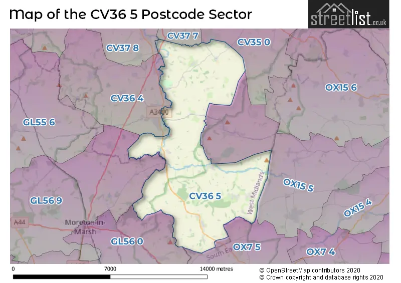
The CV36 5 Postcode shares a border with OX15 5 (Hook Norton, Lower Brailes, Sibford Ferris), OX7 5 (CHIPPING NORTON, Great Rollright, Over Norton), GL56 0 (MORETON-IN-MARSH, Longborough, Broadwell), GL56 9 (Blockley, MORETON-IN-MARSH, Stretton On Fosse), CV35 0 (Kineton, Lighthorne, Gaydon), CV36 4 (SHIPSTON-ON-STOUR, Ilmington, Tredington), CV37 7 (STRATFORD-UPON-AVON, Tiddington, Ettington) and CV37 8 (Welford On Avon, Lower Quinton, Meon Vale).
The sector is within the post town of SHIPSTON-ON-STOUR.
CV36 5 is a postcode sector within the CV36 postcode district which is within the CV Coventry postcode area.
The Royal Mail delivery office for the CV36 5 postal sector is the Stratford Upon Avon Delivery Office and Long Compton Scale Payment Delivery Office and Whichford Scale Payment Delivery Office.
The area of the CV36 5 postcode sector is 32.00 square miles which is 82.87 square kilometres or 20,478.24 square acres.
Waterways within the CV36 5 postcode sector include the River Stour.

Map of the CV36 5 Postcode Sector
Explore the CV36 5 postcode sector by using our free interactive map.
| C | V | 3 | 6 | - | 5 | X | X |
| C | V | 3 | 6 | Space | 5 | Letter | Letter |
Official List of Streets
Willington (3 Streets)
Long Compton (28 Streets)
Whatcote (7 Streets)
Idlicote (3 Streets)
SHIPSTON-ON-STOUR (1 Streets)
Great Wolford (7 Streets)
Cherington (7 Streets)
Halford (11 Streets)
Whichford (5 Streets)
Honington (1 Streets)
Ascott (1 Streets)
Burmington (5 Streets)
Little Wolford (5 Streets)
Stourton (3 Streets)
Unofficial Streets or Alternative Spellings
Bretford
FOSSE WAYChesterton
FOSSE WAYSHIPSTON-ON-STOUR
LONDON ROAD MILL STREETArmscote
HALFORD ROADSchools and Places of Education Within the CV36 5 Postcode Sector
Acorns Primary School
Academy converter
School Close, Shipston-on-Stour, Warwickshire, CV36 5LA
Head: Christian Hilton
Ofsted Rating: Good
Inspection: 2022-11-02 (568 days ago)
Website: Visit Acorns Primary School Website
Phone: 01608684654
Number of Pupils: 93
House Prices in the CV36 5 Postcode Sector
| Type of Property | 2018 Average | 2018 Sales | 2017 Average | 2017 Sales | 2016 Average | 2016 Sales | 2015 Average | 2015 Sales |
|---|---|---|---|---|---|---|---|---|
| Detached | £657,283 | 23 | £671,900 | 30 | £635,038 | 26 | £745,113 | 15 |
| Semi-Detached | £338,139 | 18 | £376,607 | 14 | £298,359 | 7 | £401,288 | 13 |
| Terraced | £282,500 | 5 | £274,328 | 9 | £379,441 | 15 | £318,167 | 15 |
| Flats | £76,000 | 1 | £0 | 0 | £0 | 0 | £68,750 | 2 |
Important Postcodes CV36 5 in the Postcode Sector
CV36 5LA is the postcode for Acorns Primary School, Long Compton
| The CV36 5 Sector is within these Local Authorities |
|
|---|---|
| The CV36 5 Sector is within these Counties |
|
| The CV36 5 Sector is within these Water Company Areas |
|