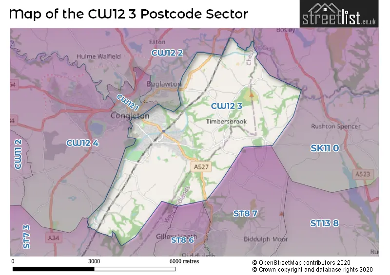
The CW12 3 postcode sector stands on the Staffordshire and Cheshire border.
Did you know? According to the 2021 Census, the CW12 3 postcode sector is home to a bustling 10,526 residents!
Given that each sector allows for 400 unique postcode combinations. Letters C, I, K, M, O and V are not allowed in the last two letters of a postcode. With 261 postcodes already in use, this leaves 139 units available.
The largest settlement in the CW12 3 postal code is CONGLETON followed by Astbury, and Moreton.
The CW12 3 Postcode shares a border with SK11 0 (Sutton, Rushton Spencer, Langley), ST7 3 (Scholar Green, Church Lawton, Rode Heath), ST8 6 (Biddulph, Knypersley, Gillow Heath), ST8 7 (Biddulph, Knypersley, Biddulph Moor), CW12 4 (CONGLETON, Somerford, Astbury), CW12 1 (CONGLETON, Eaton Bank Trading Estate) and CW12 2 (CONGLETON, Eaton, North Rode).
The sector is within the post town of CONGLETON.
CW12 3 is a postcode sector within the CW1 postcode district which is within the CW Crewe postcode area.
The Royal Mail delivery office for the CW12 3 postal sector is the Crewe Delivery Office.
The area of the CW12 3 postcode sector is 10.21 square miles which is 26.45 square kilometres or 6,536.58 square acres.
Waterways within the CW12 3 postcode sector include the Macclesfield Canal.

Map of the CW12 3 Postcode Sector
Explore the CW12 3 postcode sector by using our free interactive map.
| C | W | 1 | 2 | - | 3 | X | X |
| C | W | 1 | 2 | Space | 3 | Letter | Letter |
Official List of Streets
CONGLETON (174 Streets)
Whitemore (1 Streets)
Astbury (6 Streets)
Newbold Astbury (4 Streets)
Unofficial Streets or Alternative Spellings
Bosley
BUXTON ROAD TUNSTALL ROADCONGLETON
EDINBURGH PLACE LACY COURT PARNELL SQUARE ACKERS CROSSING SUBWAY ALBANY MILL BIDDULPH TOWN BW 79 BIDDULPH TOWN FP 68 BIDDULPH TOWN FP 78 BIDDULPH TOWN FP 80 BIDDULPH VALLEY WAY BUNTS LANE CLOUD DOWNHILL CLOUD SIDE DITCHWAY FP 88 FP 96 KNOTTY LANE LINKSWAY CLOSE LONG EDGE ROAD LONG POOL MILL LANE MOORINGS MOUNT PLEASANT PEAR TREE BANK PECKS ROAD PINES LANE RED LANE THE FLASH TOFT GREEN LANE TRINITY COURT WHARF LANE WILLOWSHAW WOODHOUSE GREENNewbold Astbury
OAK LANEBiddulph
BIDDULPH COMMON ROAD CONGLETON ROAD OVERTON ROADRushton Spencer
BEAT LANEScholar Green
STATION ROADWeather Forecast for CW12 3
Press Button to Show Forecast for Biddulph Grange Gardens
| Time Period | Icon | Description | Temperature | Rain Probability | Wind |
|---|---|---|---|---|---|
| 06:00 to 09:00 | Overcast | 10.0°C (feels like 10.0°C) | 12.00% | NW 2 mph | |
| 09:00 to 12:00 | Overcast | 11.0°C (feels like 10.0°C) | 22.00% | WNW 7 mph | |
| 12:00 to 15:00 | Light rain | 12.0°C (feels like 11.0°C) | 58.00% | WNW 7 mph | |
| 15:00 to 18:00 | Heavy rain | 13.0°C (feels like 11.0°C) | 71.00% | W 7 mph | |
| 18:00 to 21:00 | Heavy rain | 12.0°C (feels like 11.0°C) | 76.00% | WSW 7 mph | |
| 21:00 to 00:00 | Heavy rain | 10.0°C (feels like 9.0°C) | 70.00% | SW 7 mph |
Press Button to Show Forecast for Biddulph Grange Gardens
| Time Period | Icon | Description | Temperature | Rain Probability | Wind |
|---|---|---|---|---|---|
| 00:00 to 03:00 | Light rain | 9.0°C (feels like 8.0°C) | 49.00% | SW 7 mph | |
| 03:00 to 06:00 | Overcast | 9.0°C (feels like 7.0°C) | 18.00% | SSW 7 mph | |
| 06:00 to 09:00 | Overcast | 9.0°C (feels like 7.0°C) | 13.00% | SSW 7 mph | |
| 09:00 to 12:00 | Overcast | 11.0°C (feels like 10.0°C) | 11.00% | SSW 9 mph | |
| 12:00 to 15:00 | Overcast | 14.0°C (feels like 12.0°C) | 12.00% | SSW 9 mph | |
| 15:00 to 18:00 | Overcast | 14.0°C (feels like 13.0°C) | 13.00% | SSW 9 mph | |
| 18:00 to 21:00 | Cloudy | 14.0°C (feels like 13.0°C) | 11.00% | SSW 4 mph | |
| 21:00 to 00:00 | Cloudy | 10.0°C (feels like 10.0°C) | 11.00% | SSE 4 mph |
Press Button to Show Forecast for Biddulph Grange Gardens
| Time Period | Icon | Description | Temperature | Rain Probability | Wind |
|---|---|---|---|---|---|
| 00:00 to 03:00 | Cloudy | 9.0°C (feels like 8.0°C) | 12.00% | SSE 4 mph | |
| 03:00 to 06:00 | Cloudy | 8.0°C (feels like 7.0°C) | 8.00% | SE 7 mph | |
| 06:00 to 09:00 | Cloudy | 9.0°C (feels like 8.0°C) | 14.00% | SE 4 mph | |
| 09:00 to 12:00 | Cloudy | 13.0°C (feels like 12.0°C) | 10.00% | SE 7 mph | |
| 12:00 to 15:00 | Cloudy | 14.0°C (feels like 13.0°C) | 13.00% | SSE 7 mph | |
| 15:00 to 18:00 | Cloudy | 15.0°C (feels like 13.0°C) | 17.00% | WSW 7 mph | |
| 18:00 to 21:00 | Cloudy | 13.0°C (feels like 12.0°C) | 16.00% | WSW 7 mph | |
| 21:00 to 00:00 | Partly cloudy (night) | 11.0°C (feels like 10.0°C) | 8.00% | W 7 mph |
Schools and Places of Education Within the CW12 3 Postcode Sector
Daven Primary School
Academy converter
New Street, Congleton, Cheshire, CW12 3AH
Head: Mrs Jennifer Gosling
Ofsted Rating: Requires improvement
Inspection: 2023-09-27 (219 days ago)
Website: Visit Daven Primary School Website
Phone: 01260228088
Number of Pupils: 145
Mossley CofE Primary School
Academy converter
Boundary Lane, Congleton, Cheshire, CW12 3JA
Head: Mrs Helen Harrison
Ofsted Rating: Good
Inspection: 2019-09-18 (1689 days ago)
Website: Visit Mossley CofE Primary School Website
Phone: 01260272451
Number of Pupils: 427
House Prices in the CW12 3 Postcode Sector
| Type of Property | 2018 Average | 2018 Sales | 2017 Average | 2017 Sales | 2016 Average | 2016 Sales | 2015 Average | 2015 Sales |
|---|---|---|---|---|---|---|---|---|
| Detached | £313,748 | 72 | £318,343 | 99 | £307,082 | 64 | £290,253 | 60 |
| Semi-Detached | £195,603 | 64 | £181,695 | 75 | £163,221 | 53 | £169,294 | 71 |
| Terraced | £155,415 | 22 | £147,382 | 30 | £126,431 | 28 | £113,893 | 28 |
| Flats | £109,071 | 7 | £103,068 | 14 | £116,600 | 11 | £94,677 | 11 |
Important Postcodes CW12 3 in the Postcode Sector
CW12 3AH is the postcode for Daven Primary School, New Street
CW12 3AR is the postcode for East Cheshire NHS Trust, Congleton War Memorial Hospital, and East Cheshire NHS Trust, Congleton War Memorial Hospital, Canal Road
CW12 3JA is the postcode for Mossley C of E Primary School, Boundary Lane
CW12 3PQ is the postcode for BLOCK L, Buglawton Hall School, Buxton Road, BLOCK A, Buglawton Hall School, Buxton Road, and OLD HALL, Buglawton Hall School, Buxton Road
| The CW12 3 Sector is within these Local Authorities |
|
|---|---|
| The CW12 3 Sector is within these Counties |
|
| The CW12 3 Sector is within these Water Company Areas |
|