The DE72 postcode district is a postal district located in the DE Derby postcode area with a population of 20,451 residents according to the 2021 England and Wales Census.
The area of the DE72 postcode district is 23.31 square miles which is 60.37 square kilometres or 14,918.36 acres.
Currently, the DE72 district has about 457 postcode units spread across 2 geographic postcode sectors.
Given that each sector allows for 400 unique postcode combinations, the district has a capacity of 800 postcodes. With 457 postcodes already in use, this leaves 343 units available.
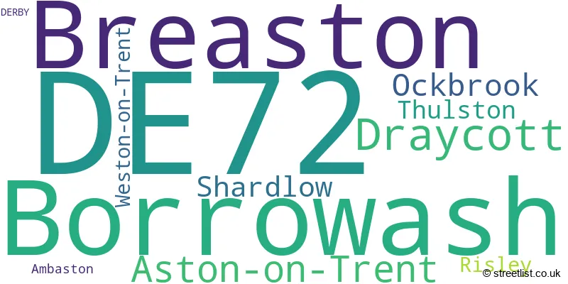
The largest settlement in the DE72 postal code is Borrowash followed by Breaston, and Draycott.
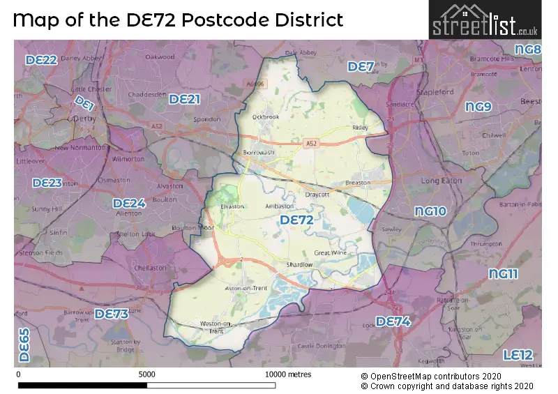
The DE72 Postcode shares a border with DE24 (Alvaston, DERBY, Sinfin), DE73 (Chellaston, Melbourne, Ticknall), NG10 (Long Eaton, Sandiacre), DE21 (Chaddesden, Spondon, DERBY), DE7 (ILKESTON, West Hallam, Smalley) and DE74 (Castle Donington, Kegworth, Diseworth).
The primary settlement in the DE72 postcode district is Aston-on-Trent, located in Derbyshire, England. Other significant settlements in the district include Shardlow in Derbyshire, Weston-on-Trent in Derbyshire, Ambaston in Derbyshire, Borrowash in Derbyshire, Breaston in Derbyshire, Draycott in Derbyshire, Ockbrook in Derbyshire, Risley in Derbyshire, and Thulston in Derbyshire. The main post town in the district is Derby.
For the district DE72, we have data on 2 postcode sectors. Here's a breakdown: The sector DE72 2, covers Aston-On-Trent and Shardlow and Weston-On-Trent in Derbyshire. The sector DE72 3, covers Borrowash and Breaston and Draycott and Ockbrook in Derbyshire.

Map of the DE72 Postcode District
Explore the DE72 postcode district by using our free interactive map.
When it comes to local government, postal geography often disregards political borders. However, for a breakdown in the DE72 District: the district mostly encompasses the Erewash District (B) (315 postcodes), followed by the South Derbyshire District area (132 postcodes), and finally, the North West Leicestershire District area (3 postcodes).
Weather Forecast for DE72
Press Button to Show Forecast for Derby County F.C.
| Time Period | Icon | Description | Temperature | Rain Probability | Wind |
|---|---|---|---|---|---|
| 03:00 to 06:00 | Cloudy | 3.0°C (feels like 2.0°C) | 4.00% | NE 4 mph | |
| 06:00 to 09:00 | Cloudy | 4.0°C (feels like 2.0°C) | 4.00% | NE 4 mph | |
| 09:00 to 12:00 | Partly cloudy (day) | 7.0°C (feels like 5.0°C) | 2.00% | ENE 7 mph | |
| 12:00 to 15:00 | Overcast | 9.0°C (feels like 8.0°C) | 9.00% | ENE 4 mph | |
| 15:00 to 18:00 | Cloudy | 10.0°C (feels like 9.0°C) | 8.00% | ENE 4 mph | |
| 18:00 to 21:00 | Cloudy | 9.0°C (feels like 7.0°C) | 9.00% | ENE 7 mph | |
| 21:00 to 00:00 | Partly cloudy (night) | 6.0°C (feels like 4.0°C) | 7.00% | ENE 7 mph |
Press Button to Show Forecast for Derby County F.C.
| Time Period | Icon | Description | Temperature | Rain Probability | Wind |
|---|---|---|---|---|---|
| 00:00 to 03:00 | Partly cloudy (night) | 5.0°C (feels like 3.0°C) | 7.00% | ENE 7 mph | |
| 03:00 to 06:00 | Cloudy | 4.0°C (feels like 2.0°C) | 13.00% | ENE 7 mph | |
| 06:00 to 09:00 | Cloudy | 5.0°C (feels like 2.0°C) | 11.00% | NE 7 mph | |
| 09:00 to 12:00 | Overcast | 8.0°C (feels like 5.0°C) | 15.00% | ENE 9 mph | |
| 12:00 to 15:00 | Overcast | 10.0°C (feels like 7.0°C) | 23.00% | ENE 11 mph | |
| 15:00 to 18:00 | Overcast | 10.0°C (feels like 8.0°C) | 22.00% | ENE 11 mph | |
| 18:00 to 21:00 | Cloudy | 10.0°C (feels like 7.0°C) | 18.00% | ENE 11 mph | |
| 21:00 to 00:00 | Cloudy | 8.0°C (feels like 5.0°C) | 17.00% | NE 11 mph |
Press Button to Show Forecast for Derby County F.C.
| Time Period | Icon | Description | Temperature | Rain Probability | Wind |
|---|---|---|---|---|---|
| 00:00 to 03:00 | Light rain | 7.0°C (feels like 4.0°C) | 50.00% | NE 11 mph | |
| 03:00 to 06:00 | Overcast | 7.0°C (feels like 4.0°C) | 25.00% | NE 11 mph | |
| 06:00 to 09:00 | Heavy rain | 8.0°C (feels like 5.0°C) | 76.00% | NE 9 mph | |
| 09:00 to 12:00 | Heavy rain | 9.0°C (feels like 7.0°C) | 78.00% | NE 9 mph | |
| 12:00 to 15:00 | Heavy rain shower (day) | 11.0°C (feels like 9.0°C) | 60.00% | NE 9 mph | |
| 15:00 to 18:00 | Heavy rain shower (day) | 12.0°C (feels like 9.0°C) | 58.00% | NE 9 mph | |
| 18:00 to 21:00 | Light rain shower (day) | 11.0°C (feels like 9.0°C) | 39.00% | ENE 9 mph | |
| 21:00 to 00:00 | Cloudy | 9.0°C (feels like 7.0°C) | 11.00% | S 7 mph |
Where is the DE72 Postcode District?
The postcode district DE72 is located in DERBY. DERBY is the nearest district town to DE72. Additionally, DE72 is approximately 108.9 miles away from the center of London. Nearby towns to DE72 include ILKESTON to the North (6.12 miles), LOUGHBOROUGH to the South East (10.15 miles), COALVILLE to the South (10.42 miles), NOTTINGHAM to the North East (10.43 miles), ASHBY-DE-LA-ZOUCH to the South West (10.74 miles), and BELPER to the North West (10.99 miles).
The district is within the post town of DERBY.
The sector has postcodes within the nation of England.
The DE72 Postcode District is covers the following regions.
- South and West Derbyshire - Derbyshire and Nottinghamshire - East Midlands (England)
- Leicestershire CC and Rutland - Leicestershire, Rutland and Northamptonshire - East Midlands (England)
- Derby - Derbyshire and Nottinghamshire - East Midlands (England)
| Postcode Sector | Delivery Office |
|---|---|
| DE72 2 | Derby Provincial Delivery Office |
| DE72 3 | Derby Provincial Delivery Office |
| D | E | 7 | 2 | - | X | X | X |
| D | E | 7 | 2 | Space | Numeric | Letter | Letter |
Tourist Attractions within the Postcode Area
We found 1 visitor attractions within the DE72 postcode area
| Shardlow Heritage Centre |
|---|
| Visitor Centres |
| Heritage / Visitor Centre |
| View Shardlow Heritage Centre on Google Maps |
Current Monthly Rental Prices
| # Bedrooms | Min Price | Max Price | Avg Price |
|---|---|---|---|
| 1 | £450 | £675 | £563 |
| 2 | £800 | £1,300 | £937 |
| 3 | £850 | £1,300 | £1,119 |
| 4 | £1,850 | £1,850 | £1,850 |
| 6 | £2,700 | £2,700 | £2,700 |
Current House Prices
| # Bedrooms | Min Price | Max Price | Avg Price |
|---|---|---|---|
| £50,000 | £335,000 | £228,333 | |
| 1 | £90,000 | £295,000 | £218,457 |
| 2 | £109,000 | £429,950 | £267,931 |
| 3 | £190,000 | £550,000 | £312,197 |
| 4 | £240,000 | £825,000 | £496,059 |
| 5 | £538,000 | £1,150,000 | £755,300 |
| 6 | £845,000 | £1,750,000 | £1,297,500 |
| 8 | £550,000 | £550,000 | £550,000 |
Estate Agents who Operate in the DE72 District
| Logo | Name | Brand Name | Address | Contact Number | Total Properties |
|---|---|---|---|---|---|
 | Long Eaton | Robert Ellis | 5 Derby Road Long Eaton Nottingham NG10 1LU | 0115 647 2153 | 56 |
 | Cheltenham | Richmond Villages | Richmond Villages, The Lodge, Hatherley Lane, Cheltenham, Gloucestershire, GL51 6PN | 01926 895829 | 23 |
 | Derby | Everington & Ruddle | 7 Derby Road, Borrowash, Derby, DE72 3JW | 01332 215068 | 19 |
 | Chellaston | Hannells Estate Agents | 55-57 High Street, Chellaston, DE73 6TB | 01332 215260 | 15 |
 | Derby | Towns & Crawford Sales & Letting Agent | 48 Main Street, Breaston, DE72 3DX | 01332 215494 | 14 |
| Type of Property | 2018 Average | 2018 Sales | 2017 Average | 2017 Sales | 2016 Average | 2016 Sales | 2015 Average | 2015 Sales |
|---|---|---|---|---|---|---|---|---|
| Detached | £337,412 | 180 | £314,344 | 144 | £323,540 | 166 | £314,195 | 166 |
| Semi-Detached | £194,112 | 110 | £194,021 | 108 | £174,379 | 117 | £170,881 | 135 |
| Terraced | £172,520 | 51 | £159,621 | 54 | £156,625 | 54 | £148,602 | 70 |
| Flats | £281,160 | 56 | £268,861 | 53 | £184,959 | 115 | £109,708 | 24 |