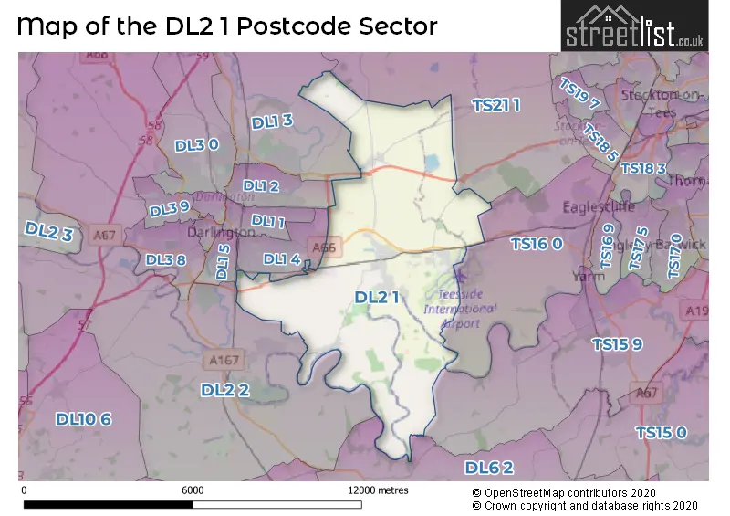
The DL2 1 postcode sector stands on the Durham and North Yorkshire border.
Did you know? According to the 2021 Census, the DL2 1 postcode sector is home to a bustling 6,789 residents!
Given that each sector allows for 400 unique postcode combinations. Letters C, I, K, M, O and V are not allowed in the last two letters of a postcode. With 237 postcodes already in use, this leaves 163 units available.
The largest settlement in the DL2 1 postal code is Middleton St. George followed by Hurworth Moor, and Sadberge.
The DL2 1 Postcode shares a border with DL1 3 (DARLINGTON, Coatham Mundeville, Brafferton), DL2 2 (DARLINGTON, Hurworth, Hurworth Place), DL6 2 (Brompton, NORTHALLERTON, Appleton Wiske), TS15 9 (YARM, Kirklevington, Hilton), TS16 0 (Eaglescliffe, STOCKTON-ON-TEES), TS21 1 (Stillington, Carlton, Long Newton), DL1 2 (DARLINGTON), DL1 4 (DARLINGTON) and DL1 5 (DARLINGTON).
The sector is within the post town of DARLINGTON.
DL2 1 is a postcode sector within the DL2 postcode district which is within the DL Darlington postcode area.
The Royal Mail delivery office for the DL2 1 postal sector is the Darlington Delivery Office.
The area of the DL2 1 postcode sector is 22.28 square miles which is 57.71 square kilometres or 14,259.22 square acres.
The DL2 1 postcode sector is crossed by the A66 Major A road.
Waterways within the DL2 1 postcode sector include the River Tees.


Map of the DL2 1 Postcode Sector
Explore the DL2 1 postcode sector by using our free interactive map.
| D | L | 2 | - | 1 | X | X |
| D | L | 2 | Space | 1 | Letter | Letter |
Official List of Streets
Sadberge (26 Streets)
Middleton St. George (88 Streets)
Middleton One Row (6 Streets)
Teesside International Airport (1 Streets)
Hurworth Moor (9 Streets)
Unofficial Streets or Alternative Spellings
Whinney Hill
DARLINGTON BACK LANESadberge
HILLHOUSE LANEDARLINGTON
YARM ROADHurworth
NEASHAM ROAD ROUNDHILL ROAD CATKILL LANE CHELTENHAM COURT DARLINGTON EASTERN TRANSPORT CORRIDOR GIRSBY BRIDGE NEASHAM HALL BRIDGE ST GEORGE WAY THE WATERSIDE WOODLANDS GARDENSGreat Burdon
BISHOPTON LANELong Newton
MILL LANESchools and Places of Education Within the DL2 1 Postcode Sector
St. George's Church of England Academy
Academy converter
Neasham Road, Darlington, County Durham, DL2 1LD
Head: Mrs Judith Skirving
Ofsted Rating: Good
Inspection: 2023-02-16 (477 days ago)
Website: Visit St. George's Church of England Academy Website
Phone: 01325332230
Number of Pupils: 408
House Prices in the DL2 1 Postcode Sector
| Type of Property | 2018 Average | 2018 Sales | 2017 Average | 2017 Sales | 2016 Average | 2016 Sales | 2015 Average | 2015 Sales |
|---|---|---|---|---|---|---|---|---|
| Detached | £265,748 | 97 | £238,146 | 53 | £281,243 | 50 | £268,691 | 52 |
| Semi-Detached | £182,776 | 53 | £174,380 | 61 | £216,339 | 22 | £204,277 | 30 |
| Terraced | £131,705 | 21 | £126,036 | 29 | £133,375 | 16 | £168,410 | 20 |
| Flats | £199,600 | 5 | £163,992 | 6 | £156,000 | 6 | £117,500 | 2 |
Important Postcodes DL2 1 in the Postcode Sector
DL2 1LD is the postcode for St. Georges Church of England Academy, Neasham Road, Middleton St. George, and St. Georges Church of England Academy, Neasham Road
| The DL2 1 Sector is within these Local Authorities |
|
|---|---|
| The DL2 1 Sector is within these Counties |
|
| The DL2 1 Sector is within these Water Company Areas |
|