Did you know? According to the 2021 Census, the DN14 9 postcode sector is home to a bustling 6,417 residents!
Given that each sector allows for 400 unique postcode combinations. Letters C, I, K, M, O and V are not allowed in the last two letters of a postcode. With 237 postcodes already in use, this leaves 163 units available.
The largest settlement in the DN14 9 postal code is Carlton followed by Snaith, and Sykehouse.
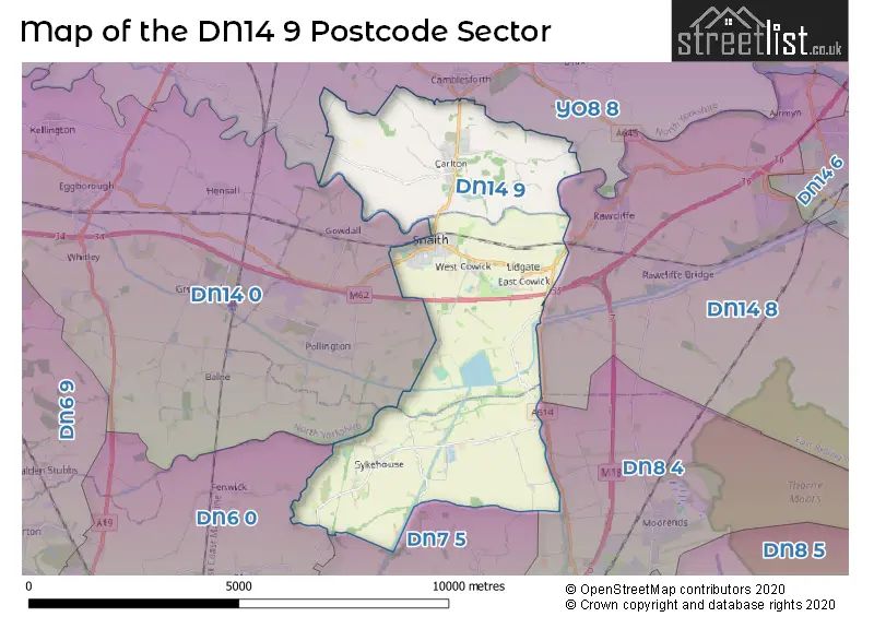
The DN14 9 Postcode shares a border with DN7 5 (Stainforth, Fishlake, Kirkhouse Green), DN14 8 (Rawcliffe, Swinefleet, Rawcliffe Bridge), YO8 8 (SELBY, Camblesforth, Barlow), DN6 0 (Askern, Moss, Fenwick), DN8 4 (Thorne, Moorends) and DN14 0 (Eggborough, Whitley, Hensall).
The sector is within the post town of GOOLE.
DN14 9 is a postcode sector within the DN14 postcode district which is within the DN Doncaster postcode area.
The Royal Mail delivery office for the DN14 9 postal sector is the Goole Delivery Office.
The area of the DN14 9 postcode sector is 16.43 square miles which is 42.56 square kilometres or 10,516.80 square acres.

Map of the DN14 9 Postcode Sector
Explore the DN14 9 postcode sector by using our free interactive map.
| D | N | 1 | 4 | - | 9 | X | X |
| D | N | 1 | 4 | Space | 9 | Letter | Letter |
Official List of Streets
Snaith (66 Streets)
Carlton (55 Streets)
East Cowick (7 Streets)
Sykehouse (24 Streets)
West Cowick (13 Streets)
Rawcliffe (1 Streets)
Unofficial Streets or Alternative Spellings
Snaith
MARKET COURT ORCHARD CLOSEFenwick
FLASHLEY CARR LANECarlton
CONVENT WALKCamblesforth
HARDENSHAW LANEHirst Courtney
OLD LANESchools and Places of Education Within the DN14 9 Postcode Sector
Carlton Primary School
Academy converter
Townend Avenue, Goole, , DN14 9NR
Head: Mr Jon Watson
Ofsted Rating: Good
Inspection: 2023-11-29 (176 days ago)
Website: Visit Carlton Primary School Website
Phone: 01405860736
Number of Pupils: 155
Cowick Church of England Voluntary Controlled Primary School
Voluntary controlled school
Snaith Road, Goole, , DN14 9DG
Head: Mrs Katherine Rawes
Ofsted Rating: Good
Inspection: 2023-03-08 (442 days ago)
Website: Visit Cowick Church of England Voluntary Controlled Primary School Website
Phone: 01405860417
Number of Pupils: 106
Snaith Primary School
Community school
Bourn Mill Balk Rd, Goole, East Yorkshire, DN14 9RD
Head: Mrs Helen Calpin
Ofsted Rating: Outstanding
Inspection: 2017-03-03 (2638 days ago)
Website: Visit Snaith Primary School Website
Phone: 01405860452
Number of Pupils: 334
The Snaith School
Academy converter
Pontefract Road, Goole, East Yorkshire, DN14 9LB
Head: Mrs Heather Yates
Ofsted Rating: Good
Inspection: 2022-05-05 (749 days ago)
Website: Visit The Snaith School Website
Phone: 01405860327
Number of Pupils: 849
House Prices in the DN14 9 Postcode Sector
| Type of Property | 2018 Average | 2018 Sales | 2017 Average | 2017 Sales | 2016 Average | 2016 Sales | 2015 Average | 2015 Sales |
|---|---|---|---|---|---|---|---|---|
| Detached | £263,659 | 79 | £244,070 | 55 | £249,852 | 46 | £224,410 | 60 |
| Semi-Detached | £167,576 | 51 | £156,486 | 36 | £141,943 | 36 | £144,436 | 36 |
| Terraced | £165,549 | 20 | £138,018 | 14 | £146,324 | 17 | £124,000 | 17 |
| Flats | £0 | 0 | £0 | 0 | £0 | 0 | £0 | 0 |
Important Postcodes DN14 9 in the Postcode Sector
DN14 9DG is the postcode for Cowick C of E Primary School, Snaith Road
DN14 9DY is the postcode for The Medical Centre, The Marshes, Butt Lane, and The Medical Centre, The Marshes, Butt Lane, Snaith
DN14 9LB is the postcode for The Snaith School, Pontefract Road, and The Snaith School, Pontefract Road, Snaith
DN14 9NR is the postcode for MAIN BUILDING, Carlton-in-Snaith Cp School, Town End Avenue, Carlton-in-Snaith Cp School, Town End Avenue, Carlton, and Carlton-in-Snaith Cp School, Town End Avenue
DN14 9NS is the postcode for Holy Family Roman Catholic High School, Long Hedge Lane, Carlton, Holy Family Catholic High School, Station Road, and Holy Family Catholic High School, Station Road, Carlton
DN14 9RD is the postcode for Snaith Primary School, Balk Lane, and SNAITH PRIMARY SCHOOL, BOURN MILL BALK ROAD
| The DN14 9 Sector is within these Local Authorities | |
|---|---|
| The DN14 9 Sector is within these Counties | |
| The DN14 9 Sector is within these Water Company Areas |