The EN8 postcode district is a postal district located in the EN Enfield postcode area with a population of 39,368 residents according to the 2021 England and Wales Census.
The area of the EN8 postcode district is 4.31 square miles which is 11.17 square kilometres or 2,761.30 acres.
Currently, the EN8 district has about 924 postcode units spread across 4 geographic postcode sectors.
Given that each sector allows for 400 unique postcode combinations, the district has a capacity of 1,600 postcodes. With 924 postcodes already in use, this leaves 676 units available.
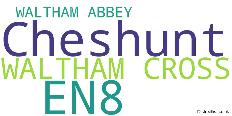
The largest settlements in the EN8 postal code are CHESHUNT and WALTHAM CROSS.
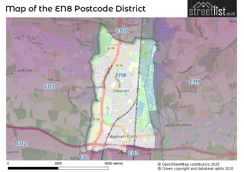
The EN8 Postcode shares a border with EN10 (BROXBOURNE, Turnford, Wormley), EN7 (CHESHUNT, GOFFS OAK), EN1 (ENFIELD), EN3 (ENFIELD) and EN9 (WALTHAM ABBEY).
In the EN8 postcode district, the primary settlement is Waltham Cross, which is located in Hertfordshire. The most significant post town in this district is Waltham Cross, which is also in Hertfordshire. Additionally, the settlement Cheshunt is present in the district, which is also located in Hertfordshire. In terms of counties, the district includes Hertfordshire and Greater London.
For the district EN8, we have data on 5 postcode sectors. Here's a breakdown: The sector EN8 0, covers Cheshunt in Hertfordshire. The sector EN8 1 is non-geographic. It's often designated for PO Boxes, large organisations, or special services. The sector EN8 7, covers Waltham Cross in Hertfordshire. The sector EN8 8, covers Cheshunt and Waltham Cross in Hertfordshire. The sector EN8 8, covers Waltham Cross in Greater London. The sector EN8 9, covers Cheshunt in Hertfordshire.

Map of the EN8 Postcode District
Explore the EN8 postcode district by using our free interactive map.
When it comes to local government, postal geography often disregards political borders. However, for a breakdown in the EN8 District: the district mostly encompasses the Broxbourne District (B) (901 postcodes), and finally, the Enfield London Boro area (30 postcodes).
Recent House Sales in EN8
| Date | Price | Address |
|---|---|---|
| 27/10/2023 | £362,500 | Aldermere Avenue, Cheshunt, Waltham Cross, EN8 0FF |
| 06/10/2023 | £942,000 | Turners Hill, Cheshunt, Waltham Cross, EN8 9BD |
| 05/10/2023 | £519,995 | Mortimer Gate, Cheshunt, Waltham Cross, EN8 0XG |
| 03/10/2023 | £2,000,000 | Britannia Road, Waltham Cross, EN8 7NY |
| 15/09/2023 | £515,000 | Gaywood Avenue, Cheshunt, Waltham Cross, EN8 8QE |
| 15/09/2023 | £255,000 | Cassandra Gate, Cheshunt, Waltham Cross, EN8 0XE |
| 12/09/2023 | £387,000 | Eleanor Road, Waltham Cross, EN8 7DW |
| 08/09/2023 | £563,000 | Palmers Way, Cheshunt, Waltham Cross, EN8 9HT |
| 05/09/2023 | £100,000 | College Road, Cheshunt, Waltham Cross, EN8 9LZ |
| 01/09/2023 | £470,000 | Edinburgh Crescent, Waltham Cross, EN8 7QZ |
Weather Forecast for EN8
Press Button to Show Forecast for Cheshunt
| Time Period | Icon | Description | Temperature | Rain Probability | Wind |
|---|---|---|---|---|---|
| 09:00 to 12:00 | Partly cloudy (day) | 8.0°C (feels like 6.0°C) | 2.00% | ENE 7 mph | |
| 12:00 to 15:00 | Cloudy | 11.0°C (feels like 10.0°C) | 9.00% | ENE 4 mph | |
| 15:00 to 18:00 | Overcast | 11.0°C (feels like 10.0°C) | 13.00% | NE 4 mph | |
| 18:00 to 21:00 | Cloudy | 10.0°C (feels like 8.0°C) | 11.00% | ENE 7 mph | |
| 21:00 to 00:00 | Cloudy | 7.0°C (feels like 5.0°C) | 11.00% | E 7 mph |
Press Button to Show Forecast for Cheshunt
| Time Period | Icon | Description | Temperature | Rain Probability | Wind |
|---|---|---|---|---|---|
| 00:00 to 03:00 | Cloudy | 5.0°C (feels like 3.0°C) | 11.00% | ENE 4 mph | |
| 03:00 to 06:00 | Cloudy | 5.0°C (feels like 2.0°C) | 16.00% | NE 7 mph | |
| 06:00 to 09:00 | Cloudy | 5.0°C (feels like 3.0°C) | 20.00% | NE 7 mph | |
| 09:00 to 12:00 | Cloudy | 9.0°C (feels like 7.0°C) | 17.00% | ENE 9 mph | |
| 12:00 to 15:00 | Overcast | 12.0°C (feels like 10.0°C) | 21.00% | E 9 mph | |
| 15:00 to 18:00 | Light rain | 12.0°C (feels like 10.0°C) | 50.00% | E 11 mph | |
| 18:00 to 21:00 | Light rain | 11.0°C (feels like 9.0°C) | 51.00% | ENE 9 mph | |
| 21:00 to 00:00 | Light rain | 9.0°C (feels like 7.0°C) | 50.00% | NE 11 mph |
Press Button to Show Forecast for Cheshunt
| Time Period | Icon | Description | Temperature | Rain Probability | Wind |
|---|---|---|---|---|---|
| 00:00 to 03:00 | Light rain | 9.0°C (feels like 7.0°C) | 52.00% | NE 9 mph | |
| 03:00 to 06:00 | Light rain | 10.0°C (feels like 8.0°C) | 55.00% | ESE 9 mph | |
| 06:00 to 09:00 | Cloudy | 10.0°C (feels like 8.0°C) | 51.00% | SE 9 mph | |
| 09:00 to 12:00 | Light rain shower (day) | 11.0°C (feels like 9.0°C) | 42.00% | SE 9 mph | |
| 12:00 to 15:00 | Heavy rain shower (day) | 12.0°C (feels like 10.0°C) | 59.00% | S 9 mph | |
| 15:00 to 18:00 | Light rain shower (day) | 14.0°C (feels like 12.0°C) | 43.00% | SW 11 mph | |
| 18:00 to 21:00 | Cloudy | 12.0°C (feels like 10.0°C) | 17.00% | SW 11 mph | |
| 21:00 to 00:00 | Cloudy | 10.0°C (feels like 8.0°C) | 8.00% | WSW 9 mph |
Where is the EN8 Postcode District?
The postcode district EN8 is located in Waltham Cross. It is a district town that is nearby other towns such as Cheshunt (1.33 miles to the northwest), Turnford (1.56 miles to the north), Goffs Oak (2.50 miles to the west), Nazeing (3.73 miles to the east), and Enfield (3.82 miles to the southwest). Waltham Cross is approximately 13.99 miles away from the center of London.
The district covers the post towns of WALTHAM ABBEY, WALTHAM CROSS.
The sector has postcodes within the nation of England.
The EN8 Postcode District is covers the following regions.
- Hertfordshire - Bedfordshire and Hertfordshire - East of England
- Enfield - Outer London - East and North East - London
| Postcode Sector | Delivery Office |
|---|---|
| EN8 0 | Waltham Cross Delivery Office |
| EN8 7 | Waltham Cross Delivery Office |
| EN8 8 | Waltham Cross Delivery Office |
| EN8 9 | Waltham Cross Delivery Office |
| E | N | 8 | - | X | X | X |
| E | N | 8 | Space | Numeric | Letter | Letter |
Current Monthly Rental Prices
| # Bedrooms | Min Price | Max Price | Avg Price |
|---|---|---|---|
| £1,100 | £1,150 | £1,117 | |
| 1 | £925 | £1,300 | £1,117 |
| 2 | £1,475 | £1,600 | £1,525 |
| 3 | £1,600 | £1,850 | £1,770 |
Current House Prices
| # Bedrooms | Min Price | Max Price | Avg Price |
|---|---|---|---|
| £170,000 | £200,000 | £185,000 | |
| 1 | £72,500 | £450,000 | £172,262 |
| 2 | £130,000 | £550,000 | £314,221 |
| 3 | £249,995 | £665,000 | £453,118 |
| 4 | £475,000 | £850,000 | £610,107 |
| 5 | £499,995 | £1,000,000 | £701,000 |
| 6 | £575,000 | £850,000 | £712,500 |
Estate Agents who Operate in the EN8 District
| Logo | Name | Brand Name | Address | Contact Number | Total Properties |
|---|---|---|---|---|---|
 | Cheshunt | Woodhouse | 7 Clayton Parade, Turners Hill, Cheshunt, EN8 8NQ | 01992 661939 | 28 |
 | Cheshunt | Christopher Stokes | 10 Newnham Parade College Road Cheshunt EN8 9NU | 01992 662237 | 27 |
 | Cheshunt | Shepherds Estate Agents | 1High Street, Cheshunt, Waltham Cross, EN8 0BY | 01992 721333 | 26 |
 | Cheshunt | Keith Ian | 84-86 Turners Hill Cheshunt EN8 8LQ | 01992 661911 | 26 |
 | Cheshunt | Paul Wallace Estate Agents | The Brookfield Centre, Cheshunt, Hertfordshire, EN8 0NN | 01992 781133 | 24 |
| Type of Property | 2018 Average | 2018 Sales | 2017 Average | 2017 Sales | 2016 Average | 2016 Sales | 2015 Average | 2015 Sales |
|---|---|---|---|---|---|---|---|---|
| Detached | £547,056 | 88 | £503,662 | 71 | £511,454 | 30 | £432,982 | 40 |
| Semi-Detached | £401,810 | 132 | £410,380 | 115 | £386,225 | 122 | £331,057 | 135 |
| Terraced | £351,366 | 203 | £346,828 | 244 | £333,329 | 231 | £290,629 | 222 |
| Flats | £222,900 | 182 | £219,534 | 275 | £212,990 | 293 | £182,705 | 238 |