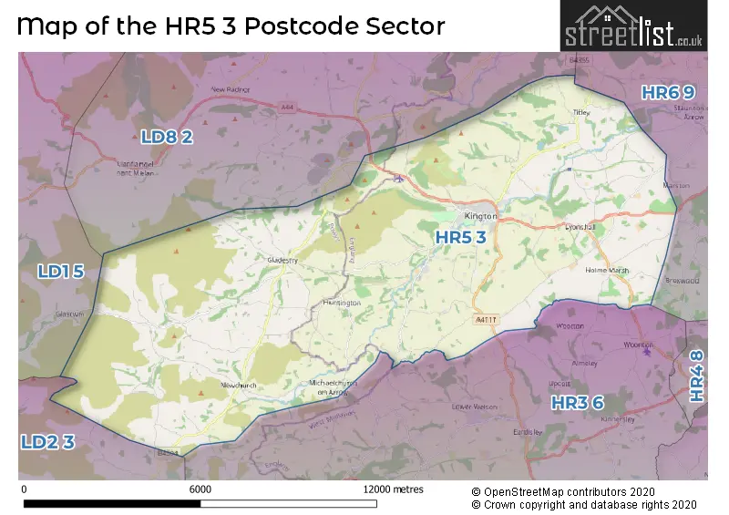
The HR5 3 postcode sector stands on the Herefordshire and Powys border.
Did you know? According to the 2021 Census, the HR5 3 postcode sector is home to a bustling 4,788 residents!
Given that each sector allows for 400 unique postcode combinations. Letters C, I, K, M, O and V are not allowed in the last two letters of a postcode. With 242 postcodes already in use, this leaves 158 units available.
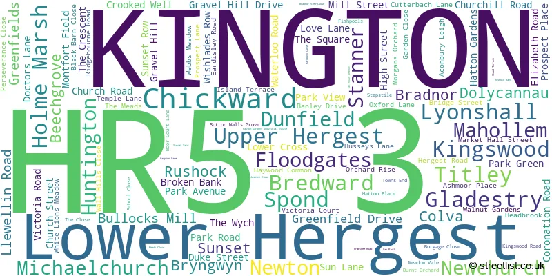
The largest settlement in the HR5 3 postal code is KINGTON followed by Lyonshall, and Titley.
The HR5 3 Postcode shares a border with HR3 6 (Eardisley, Whitney-on-Wye, Dorstone), HR6 9 (Kingsland, Pembridge, Shobdon), LD1 5 (LLANDRINDOD WELLS, HOWEY, DOLAU), LD2 3 (BUILTH WELLS, LLANELWEDD, LLANAFANFAWR) and LD8 2 (PRESTEIGNE, NEW RADNOR, NORTON).
The sector is within the post town of KINGTON.
HR5 3 is a postcode sector within the HR5 postcode district which is within the HR Hereford postcode area.
The Royal Mail delivery office for the HR5 3 postal sector is the Kington Scale Payment Delivery Office.
The area of the HR5 3 postcode sector is 55.24 square miles which is 143.07 square kilometres or 35,354.40 square acres.

Map of the HR5 3 Postcode Sector
Explore the HR5 3 postcode sector by using our free interactive map.
| H | R | 5 | - | 3 | X | X |
| H | R | 5 | Space | 3 | Letter | Letter |
Official List of Streets
KINGTON (69 Streets)
Lyonshall (7 Streets)
Stanner (1 Streets)
Floodgates (1 Streets)
Gladestry (1 Streets)
Holme Marsh (1 Streets)
Spond (1 Streets)
Rushock (1 Streets)
Titley (1 Streets)
Unofficial Streets or Alternative Spellings
Pembridge
NOKE LANEKINGTON
CAMPION LANE LOWER CROSSWeather Forecast for HR5 3
Press Button to Show Forecast for Hergest Croft Gardens
| Time Period | Icon | Description | Temperature | Rain Probability | Wind |
|---|---|---|---|---|---|
| 15:00 to 18:00 | Heavy rain | 10.0°C (feels like 7.0°C) | 87.00% | SSE 13 mph | |
| 18:00 to 21:00 | Heavy rain | 9.0°C (feels like 7.0°C) | 83.00% | SSE 9 mph | |
| 21:00 to 00:00 | Light rain | 8.0°C (feels like 7.0°C) | 53.00% | SE 7 mph |
Press Button to Show Forecast for Hergest Croft Gardens
| Time Period | Icon | Description | Temperature | Rain Probability | Wind |
|---|---|---|---|---|---|
| 00:00 to 03:00 | Mist | 8.0°C (feels like 7.0°C) | 23.00% | SE 7 mph | |
| 03:00 to 06:00 | Fog | 8.0°C (feels like 7.0°C) | 21.00% | SE 2 mph | |
| 06:00 to 09:00 | Mist | 8.0°C (feels like 8.0°C) | 18.00% | ESE 2 mph | |
| 09:00 to 12:00 | Cloudy | 10.0°C (feels like 10.0°C) | 5.00% | ESE 4 mph | |
| 12:00 to 15:00 | Cloudy | 14.0°C (feels like 13.0°C) | 7.00% | ESE 4 mph | |
| 15:00 to 18:00 | Cloudy | 14.0°C (feels like 13.0°C) | 52.00% | ESE 4 mph | |
| 18:00 to 21:00 | Light rain | 12.0°C (feels like 11.0°C) | 64.00% | NNW 4 mph | |
| 21:00 to 00:00 | Heavy rain | 11.0°C (feels like 10.0°C) | 81.00% | NNW 7 mph |
Press Button to Show Forecast for Hergest Croft Gardens
| Time Period | Icon | Description | Temperature | Rain Probability | Wind |
|---|---|---|---|---|---|
| 00:00 to 03:00 | Cloudy | 11.0°C (feels like 10.0°C) | 20.00% | NNW 7 mph | |
| 03:00 to 06:00 | Cloudy | 10.0°C (feels like 9.0°C) | 55.00% | N 9 mph | |
| 06:00 to 09:00 | Light rain | 10.0°C (feels like 8.0°C) | 51.00% | N 9 mph | |
| 09:00 to 12:00 | Light rain | 11.0°C (feels like 10.0°C) | 42.00% | NNE 9 mph | |
| 12:00 to 15:00 | Cloudy | 14.0°C (feels like 13.0°C) | 8.00% | NE 9 mph | |
| 15:00 to 18:00 | Cloudy | 16.0°C (feels like 15.0°C) | 11.00% | N 7 mph | |
| 18:00 to 21:00 | Light rain shower (day) | 14.0°C (feels like 13.0°C) | 34.00% | NNW 9 mph | |
| 21:00 to 00:00 | Light rain shower (night) | 12.0°C (feels like 10.0°C) | 32.00% | NNW 9 mph |
Press Button to Show Forecast for Hergest Croft Gardens
| Time Period | Icon | Description | Temperature | Rain Probability | Wind |
|---|---|---|---|---|---|
| 00:00 to 03:00 | Light rain | 10.0°C (feels like 9.0°C) | 41.00% | NNW 7 mph | |
| 03:00 to 06:00 | Overcast | 10.0°C (feels like 8.0°C) | 16.00% | NW 7 mph | |
| 06:00 to 09:00 | Overcast | 10.0°C (feels like 8.0°C) | 15.00% | NW 7 mph | |
| 09:00 to 12:00 | Overcast | 11.0°C (feels like 10.0°C) | 14.00% | NW 7 mph | |
| 12:00 to 15:00 | Cloudy | 13.0°C (feels like 12.0°C) | 14.00% | NW 9 mph | |
| 15:00 to 18:00 | Cloudy | 14.0°C (feels like 12.0°C) | 15.00% | WNW 9 mph | |
| 18:00 to 21:00 | Cloudy | 13.0°C (feels like 11.0°C) | 14.00% | W 9 mph | |
| 21:00 to 00:00 | Cloudy | 10.0°C (feels like 8.0°C) | 10.00% | W 7 mph |
Press Button to Show Forecast for Hergest Croft Gardens
| Time Period | Icon | Description | Temperature | Rain Probability | Wind |
|---|---|---|---|---|---|
| 00:00 to 03:00 | Partly cloudy (night) | 8.0°C (feels like 7.0°C) | 8.00% | W 7 mph | |
| 03:00 to 06:00 | Cloudy | 7.0°C (feels like 6.0°C) | 9.00% | WSW 4 mph | |
| 06:00 to 09:00 | Cloudy | 8.0°C (feels like 7.0°C) | 11.00% | WSW 4 mph | |
| 09:00 to 12:00 | Cloudy | 11.0°C (feels like 10.0°C) | 10.00% | WSW 7 mph | |
| 12:00 to 15:00 | Cloudy | 14.0°C (feels like 12.0°C) | 12.00% | SW 9 mph | |
| 15:00 to 18:00 | Cloudy | 15.0°C (feels like 13.0°C) | 16.00% | SSW 9 mph | |
| 18:00 to 21:00 | Cloudy | 14.0°C (feels like 12.0°C) | 15.00% | SSW 7 mph | |
| 21:00 to 00:00 | Cloudy | 10.0°C (feels like 9.0°C) | 7.00% | SSW 7 mph |
Schools and Places of Education Within the HR5 3 Postcode Sector
Kington Primary School
Community school
Mill Street, Kington, Herefordshire, HR5 3AL
Head: Mrs Emma Bretherton
Ofsted Rating: Good
Inspection: 2020-01-15 (1567 days ago)
Website: Visit Kington Primary School Website
Phone: 01544230363
Number of Pupils: 216
Lady Hawkins' School
Academy converter
Park View, Kington, Herefordshire, HR5 3AR
Head: Mr Allen Brace
Ofsted Rating: Good
Inspection: 2023-01-26 (460 days ago)
Website: Visit Lady Hawkins' School Website
Phone: 01544230441
Number of Pupils: 263
House Prices in the HR5 3 Postcode Sector
| Type of Property | 2018 Average | 2018 Sales | 2017 Average | 2017 Sales | 2016 Average | 2016 Sales | 2015 Average | 2015 Sales |
|---|---|---|---|---|---|---|---|---|
| Detached | £304,546 | 34 | £295,070 | 30 | £261,438 | 40 | £264,136 | 33 |
| Semi-Detached | £177,353 | 17 | £202,344 | 16 | £176,222 | 9 | £155,973 | 20 |
| Terraced | £193,714 | 7 | £147,912 | 17 | £142,433 | 15 | £156,263 | 15 |
| Flats | £86,742 | 6 | £96,167 | 3 | £102,333 | 6 | £65,000 | 3 |
Important Postcodes HR5 3 in the Postcode Sector
HR5 3AL is the postcode for Kington Primary School, Mill Street
HR5 3AR is the postcode for Lady Hawkins School, Park View, LIBRARY BLOCK, Lady Hawkins School, Park View, and ART & 6TH FORM BUILDING, Lady Hawkins School, Park View
HR5 3DJ is the postcode for Herefordshire Council, Kington Library, 64 Bridge Street
| The HR5 3 Sector is within these Local Authorities |
|
|---|---|
| The HR5 3 Sector is within these Counties |
|
| The HR5 3 Sector is within these Water Company Areas |
|
Tourist Attractions within the HR5 3 Postcode Area
We found 2 visitor attractions within the HR5 postcode area
| Hergest Croft Gardens |
|---|
| Gardens |
| Garden |
| View Hergest Croft Gardens on Google Maps |
| Hergest Gardens. |
| View Hergest Gardens. on Google Maps |