The HU10 6 postcode sector is within the county of East Riding of Yorkshire.
Did you know? According to the 2021 Census, the HU10 6 postcode sector is home to a bustling 10,588 residents!
Given that each sector allows for 400 unique postcode combinations. Letters C, I, K, M, O and V are not allowed in the last two letters of a postcode. With 250 postcodes already in use, this leaves 150 units available.
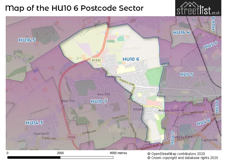
The largest settlements in the HU10 6 postal code are Willerby and Anlaby.
The HU10 6 Postcode shares a border with HU4 7 (HULL, Anlaby Common), HU13 0 (HESSLE), HU5 5 (HULL), HU10 7 (Kirk Ella, Anlaby, West Ella), HU13 9 (HESSLE) and HU16 5 (COTTINGHAM, Skidby, Raywell).
The sector is within the post town of HULL.
HU10 6 is a postcode sector within the HU10 postcode district which is within the HU Hull postcode area.
The Royal Mail delivery office for the HU10 6 postal sector is the Saxon Way Postal Delivery Office.
The area of the HU10 6 postcode sector is 3.17 square miles which is 8.20 square kilometres or 2,027.22 square acres.


Map of the HU10 6 Postcode Sector
Explore the HU10 6 postcode sector by using our free interactive map.
| H | U | 1 | 0 | - | 6 | X | X |
| H | U | 1 | 0 | Space | 6 | Letter | Letter |
Official List of Streets
Willerby (96 Streets)
Anlaby (37 Streets)
Unofficial Streets or Alternative Spellings
Anlaby
BEVERLEY ROAD LAWRANCE AVENUE PETFIELD DRIVE STROMBERG STREET THE GARTHWillerby
KINGSTON RISE ABBEY GROVE ALEXANDER GROVE APPLETREE MEWS BAILEY STREET BEVERLY ROAD CAPE COURT CAYLEY ROAD CROMWELL COURT CROSS STREET DAWSON WALK GRANGE FARM MEWS GREAT GUTTER LANE (EAST) GREAT GUTTER LANE (WEST) GREEN LANE GREENWAY CLOSE HELLYER RISE HULL & BARNSLEY LAWRENCE AVENUE ONSLOW STREET RENTON COURT ROSE AVENUE SOUTH VIEW SPRINGHEAD COURT ST THOMAS MORE ROAD TUDOR COURT WHITFIELD ROAD WILLERBY COURT WILLERBY SQUARECOTTINGHAM
TAYLOR AVENUE WILLERBY LOW ROADHULL
MAPLEWOOD AVENUE SPRINGHEAD GARDENS SPRINGHEAD LANE SWINE BANKHESSLE,
BOOTHFERRY ROADSkidby
BEVERLEY ROADAnlaby Common
HULL ROADKirk Ella
POPPY DRIVE WEST HILL ROADRaywell
WESTFIELD ROADWeather Forecast for HU10 6
Press Button to Show Forecast for East Ella
| Time Period | Icon | Description | Temperature | Rain Probability | Wind |
|---|---|---|---|---|---|
| 09:00 to 12:00 | Cloudy | 9.0°C (feels like 6.0°C) | 8.00% | ENE 9 mph | |
| 12:00 to 15:00 | Cloudy | 10.0°C (feels like 7.0°C) | 16.00% | ENE 11 mph | |
| 15:00 to 18:00 | Overcast | 9.0°C (feels like 6.0°C) | 14.00% | ENE 11 mph | |
| 18:00 to 21:00 | Cloudy | 8.0°C (feels like 5.0°C) | 9.00% | NE 11 mph | |
| 21:00 to 00:00 | Cloudy | 7.0°C (feels like 5.0°C) | 8.00% | NE 9 mph |
Press Button to Show Forecast for East Ella
| Time Period | Icon | Description | Temperature | Rain Probability | Wind |
|---|---|---|---|---|---|
| 00:00 to 03:00 | Cloudy | 7.0°C (feels like 4.0°C) | 11.00% | NNE 9 mph | |
| 03:00 to 06:00 | Overcast | 7.0°C (feels like 3.0°C) | 24.00% | NNE 11 mph | |
| 06:00 to 09:00 | Heavy rain | 7.0°C (feels like 3.0°C) | 76.00% | N 13 mph | |
| 09:00 to 12:00 | Heavy rain | 8.0°C (feels like 4.0°C) | 80.00% | N 13 mph | |
| 12:00 to 15:00 | Heavy rain | 8.0°C (feels like 5.0°C) | 76.00% | NW 13 mph | |
| 15:00 to 18:00 | Light rain | 9.0°C (feels like 6.0°C) | 50.00% | WNW 11 mph | |
| 18:00 to 21:00 | Cloudy | 10.0°C (feels like 8.0°C) | 11.00% | WSW 9 mph | |
| 21:00 to 00:00 | Clear night | 8.0°C (feels like 5.0°C) | 2.00% | SW 9 mph |
Press Button to Show Forecast for East Ella
| Time Period | Icon | Description | Temperature | Rain Probability | Wind |
|---|---|---|---|---|---|
| 00:00 to 03:00 | Clear night | 6.0°C (feels like 3.0°C) | 2.00% | SW 9 mph | |
| 03:00 to 06:00 | Clear night | 5.0°C (feels like 2.0°C) | 1.00% | SSW 9 mph | |
| 06:00 to 09:00 | Sunny day | 6.0°C (feels like 2.0°C) | 1.00% | SSW 11 mph | |
| 09:00 to 12:00 | Sunny day | 10.0°C (feels like 8.0°C) | 1.00% | S 13 mph | |
| 12:00 to 15:00 | Cloudy | 13.0°C (feels like 10.0°C) | 6.00% | S 16 mph | |
| 15:00 to 18:00 | Cloudy | 14.0°C (feels like 11.0°C) | 6.00% | SSE 16 mph | |
| 18:00 to 21:00 | Partly cloudy (day) | 13.0°C (feels like 10.0°C) | 2.00% | SSE 13 mph | |
| 21:00 to 00:00 | Partly cloudy (night) | 10.0°C (feels like 7.0°C) | 3.00% | SSE 13 mph |
Press Button to Show Forecast for East Ella
| Time Period | Icon | Description | Temperature | Rain Probability | Wind |
|---|---|---|---|---|---|
| 00:00 to 03:00 | Clear night | 9.0°C (feels like 6.0°C) | 2.00% | SSE 11 mph | |
| 03:00 to 06:00 | Clear night | 8.0°C (feels like 5.0°C) | 2.00% | SE 11 mph | |
| 06:00 to 09:00 | Sunny day | 8.0°C (feels like 6.0°C) | 5.00% | ESE 9 mph | |
| 09:00 to 12:00 | Cloudy | 12.0°C (feels like 10.0°C) | 7.00% | ESE 11 mph | |
| 12:00 to 15:00 | Cloudy | 14.0°C (feels like 11.0°C) | 9.00% | E 11 mph | |
| 15:00 to 18:00 | Cloudy | 14.0°C (feels like 12.0°C) | 11.00% | E 11 mph | |
| 18:00 to 21:00 | Cloudy | 12.0°C (feels like 10.0°C) | 9.00% | E 11 mph | |
| 21:00 to 00:00 | Cloudy | 11.0°C (feels like 9.0°C) | 9.00% | E 9 mph |
Schools and Places of Education Within the HU10 6 Postcode Sector
Anlaby Primary School
Community school
First Lane, HULL, East Yorkshire, HU10 6UE
Head: Mr Gareth May
Ofsted Rating: Good
Inspection: 2018-12-13 (1962 days ago)
Website: Visit Anlaby Primary School Website
Phone: 01482653077
Number of Pupils: 420
Springhead Primary School
Community school
Forty Steps, Hull, , HU10 6TW
Head: Mrs Naomi Prutton
Ofsted Rating: Good
Inspection: 2018-10-03 (2033 days ago)
Website: Visit Springhead Primary School Website
Phone: 01482307870
Number of Pupils: 204
Willerby Carr Lane Primary School
Community school
Carr Lane, Hull, , HU10 6JT
Head: Mrs Laura Widdowson
Ofsted Rating: Good
Inspection: 2021-11-18 (891 days ago)
Website: Visit Willerby Carr Lane Primary School Website
Phone: 01482653388
Number of Pupils: 416
Wolfreton School and Sixth Form College
Academy converter
Wolfreton School and Sixth Form College, Hull, East Yorkshire, HU10 6HB
Head: Miss Susanne Kukuc
Ofsted Rating: Good
Inspection: 2021-10-08 (932 days ago)
Website: Visit Wolfreton School and Sixth Form College Website
Phone: 01482659356
Number of Pupils: 1518
House Prices in the HU10 6 Postcode Sector
| Type of Property | 2018 Average | 2018 Sales | 2017 Average | 2017 Sales | 2016 Average | 2016 Sales | 2015 Average | 2015 Sales |
|---|---|---|---|---|---|---|---|---|
| Detached | £252,516 | 34 | £253,773 | 22 | £246,333 | 24 | £261,117 | 21 |
| Semi-Detached | £187,004 | 74 | £185,181 | 94 | £189,011 | 83 | £180,941 | 80 |
| Terraced | £160,211 | 61 | £136,470 | 68 | £133,843 | 35 | £123,295 | 38 |
| Flats | £78,798 | 29 | £92,018 | 27 | £72,097 | 25 | £71,972 | 25 |
Important Postcodes HU10 6 in the Postcode Sector
HU10 6DE is the postcode for Environment Agency, 1A Viking Close, Great Gutter Lane East
HU10 6DT is the postcode for Health House, Grange Park Lane, Willerby, and Health House, Grange Park Lane
HU10 6ED is the postcode for Mary Secole Building, Willerby Hill, THE MARY SEACOLE BUILDING, Trust Headquarters, Willerby Hill, Beverley Road, THE TECHNOLOGY CENTRE, Trust Headquarters, Willerby Hill, Beverley Road, The Learning Centre, Willerby Hill, Humber Mental Health Teaching NHS Trust, Humber Centre Forensic Unit, Green Trees Lodge, Beverley Road, Willerby, Humber Mental Health Teaching N H S Trust, Trust Headquarters Building, Beverley Road, College House, Willerby Hill, Green Trees Lodge, Beverley Road, Humber Mental Health Teaching NHS Trust, Greentrees Lodge, Humber Centre, Beverley Road, TRUST HEADQUARTERS BUILDING, Trust Headquarters, Willerby Hill, Beverley Road, Mary Seacole Building, Willerby Hill, Willerby, Humber Centre, Beverley Road, Willerby, and Green Trees Lodge, Beverley Road, Wiullerby
HU10 6HB is the postcode for SPORTS HALL, Wolfreton School & Sixth Form College, Well Lane, Wolfreton School & Sixth Form College, Well Lane, and WOLFRETON SCHOOL AND SIXTH FORM COLLEGE, WELL LANE
HU10 6HD is the postcode for Willerby Ambulance Station, Yorkshire Ambulance Service NHS Trust
HU10 6JR is the postcode for EAST WING, Wolfreton Lower School, Carr Lane, and WEST WING, Wolfreton Lower School, Carr Lane
HU10 6JT is the postcode for WILLERBY CARR LANE PRIMARY SCHOOL, CARR LANE, WILLERBY, and Willerby Carr Lane Primary School, Carr Lane
HU10 6NT is the postcode for Beverley Road, and Total Fitness 2010 Limited, Beverley Road
HU10 6QJ is the postcode for Haltemprice Leisure Centre, Springfield Way, Haltemprice Leisure Centre, Springfield Way, Anlaby, and East Riding Leisure Haltemprice, 120 Springfield Way
HU10 6TW is the postcode for SPRINGHEAD PRIMARY SCHOOL, FORTY STEPS
HU10 6UE is the postcode for Anlaby County Infant School, First Lane, Anlaby County Junior School, First Lane, Anlaby Childrens Centre, First Lane, East Riding of Yorkshire Primary Care Trust, Anlaby Clinic, First Lane, and Anlaby Primary School, First Lane
HU10 6UU is the postcode for BLOCK 5 - ADMINISTRATION AND HALL, Sydney Smith School, First Lane, BLOCK 3 SCIENCE, Sydney Smith School, First Lane, Sydney Smith School, First Lane, BLOCK 6 GENERAL TEACHING, Sydney Smith School, First Lane, BLOCK 4 ART, Sydney Smith School, First Lane, and SPORTS CENTRE AND POOL, Sydney Smith School, First Lane
| The HU10 6 Sector is within these Local Authorities |
|
|---|---|
| The HU10 6 Sector is within these Counties |
|
| The HU10 6 Sector is within these Water Company Areas |
|