The HU10 7 postcode sector is within the county of East Riding of Yorkshire.
Did you know? According to the 2021 Census, the HU10 7 postcode sector is home to a bustling 9,151 residents!
Given that each sector allows for 400 unique postcode combinations. Letters C, I, K, M, O and V are not allowed in the last two letters of a postcode. With 239 postcodes already in use, this leaves 161 units available.
The largest settlement in the HU10 7 postal code is Kirk Ella followed by Anlaby, and West Ella.
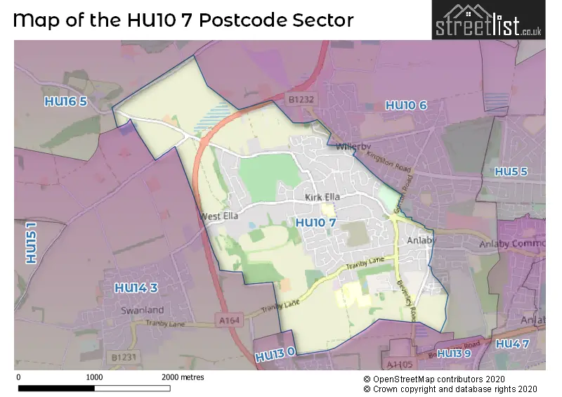
The HU10 7 Postcode shares a border with HU10 6 (Willerby, Anlaby), HU13 0 (HESSLE), HU14 3 (Swanland, NORTH FERRIBY, Melton) and HU16 5 (COTTINGHAM, Skidby, Raywell).
The sector is within the post town of HULL.
HU10 7 is a postcode sector within the HU10 postcode district which is within the HU Hull postcode area.
The Royal Mail delivery office for the HU10 7 postal sector is the Saxon Way Postal Delivery Office.
The area of the HU10 7 postcode sector is 3.14 square miles which is 8.12 square kilometres or 2,006.82 square acres.

Map of the HU10 7 Postcode Sector
Explore the HU10 7 postcode sector by using our free interactive map.
| H | U | 1 | 0 | - | 7 | X | X |
| H | U | 1 | 0 | Space | 7 | Letter | Letter |
Official List of Streets
Anlaby (55 Streets)
Kirk Ella (78 Streets)
West Ella (9 Streets)
Willerby (2 Streets)
Unofficial Streets or Alternative Spellings
Anlaby
ANLAFGATE FRASER WAY PRYME STREET SPRINGFIELD WAY WEETON WAYHESSLE
JENNY BROUGH LANE NORTHWOOD DRIVEAnlaby Common
HULL ROADWillerby
ASHDENE CLOSE GORTON ROADRaywell
WESTFIELD ROADWeather Forecast for HU10 7
Press Button to Show Forecast for Northfield (Kingston Upon Hull)
| Time Period | Icon | Description | Temperature | Rain Probability | Wind |
|---|---|---|---|---|---|
| 12:00 to 15:00 | Cloudy | 10.0°C (feels like 7.0°C) | 11.00% | ENE 11 mph | |
| 15:00 to 18:00 | Overcast | 9.0°C (feels like 6.0°C) | 13.00% | ENE 11 mph | |
| 18:00 to 21:00 | Cloudy | 8.0°C (feels like 5.0°C) | 9.00% | NE 11 mph | |
| 21:00 to 00:00 | Cloudy | 7.0°C (feels like 5.0°C) | 8.00% | NE 9 mph |
Press Button to Show Forecast for Northfield (Kingston Upon Hull)
| Time Period | Icon | Description | Temperature | Rain Probability | Wind |
|---|---|---|---|---|---|
| 00:00 to 03:00 | Cloudy | 7.0°C (feels like 4.0°C) | 11.00% | NNE 9 mph | |
| 03:00 to 06:00 | Overcast | 7.0°C (feels like 3.0°C) | 24.00% | NNE 11 mph | |
| 06:00 to 09:00 | Heavy rain | 7.0°C (feels like 3.0°C) | 76.00% | N 13 mph | |
| 09:00 to 12:00 | Heavy rain | 8.0°C (feels like 4.0°C) | 80.00% | NNW 13 mph | |
| 12:00 to 15:00 | Heavy rain | 8.0°C (feels like 5.0°C) | 76.00% | NW 13 mph | |
| 15:00 to 18:00 | Light rain | 9.0°C (feels like 6.0°C) | 50.00% | WNW 11 mph | |
| 18:00 to 21:00 | Cloudy | 10.0°C (feels like 8.0°C) | 11.00% | WSW 9 mph | |
| 21:00 to 00:00 | Clear night | 8.0°C (feels like 5.0°C) | 2.00% | SW 9 mph |
Press Button to Show Forecast for Northfield (Kingston Upon Hull)
| Time Period | Icon | Description | Temperature | Rain Probability | Wind |
|---|---|---|---|---|---|
| 00:00 to 03:00 | Clear night | 6.0°C (feels like 3.0°C) | 2.00% | SW 9 mph | |
| 03:00 to 06:00 | Clear night | 5.0°C (feels like 2.0°C) | 1.00% | SSW 9 mph | |
| 06:00 to 09:00 | Sunny day | 6.0°C (feels like 2.0°C) | 1.00% | SSW 11 mph | |
| 09:00 to 12:00 | Sunny day | 10.0°C (feels like 8.0°C) | 1.00% | S 13 mph | |
| 12:00 to 15:00 | Cloudy | 13.0°C (feels like 11.0°C) | 6.00% | S 13 mph | |
| 15:00 to 18:00 | Cloudy | 14.0°C (feels like 11.0°C) | 6.00% | S 13 mph | |
| 18:00 to 21:00 | Partly cloudy (day) | 13.0°C (feels like 11.0°C) | 2.00% | SSE 11 mph | |
| 21:00 to 00:00 | Partly cloudy (night) | 10.0°C (feels like 8.0°C) | 3.00% | SSE 11 mph |
Press Button to Show Forecast for Northfield (Kingston Upon Hull)
| Time Period | Icon | Description | Temperature | Rain Probability | Wind |
|---|---|---|---|---|---|
| 00:00 to 03:00 | Clear night | 9.0°C (feels like 6.0°C) | 2.00% | SSE 9 mph | |
| 03:00 to 06:00 | Clear night | 7.0°C (feels like 5.0°C) | 2.00% | SE 9 mph | |
| 06:00 to 09:00 | Sunny day | 9.0°C (feels like 6.0°C) | 5.00% | ESE 9 mph | |
| 09:00 to 12:00 | Cloudy | 13.0°C (feels like 11.0°C) | 7.00% | ESE 9 mph | |
| 12:00 to 15:00 | Cloudy | 14.0°C (feels like 12.0°C) | 9.00% | E 11 mph | |
| 15:00 to 18:00 | Cloudy | 15.0°C (feels like 13.0°C) | 11.00% | E 11 mph | |
| 18:00 to 21:00 | Cloudy | 13.0°C (feels like 11.0°C) | 9.00% | E 9 mph | |
| 21:00 to 00:00 | Cloudy | 11.0°C (feels like 9.0°C) | 9.00% | E 9 mph |
Schools and Places of Education Within the HU10 7 Postcode Sector
Kirk Ella St Andrew's Community Primary School
Community school
West Ella Road, Hull, , HU10 7QL
Head: Mr Jamie Church
Ofsted Rating: Good
Inspection: 2023-04-26 (367 days ago)
Website: Visit Kirk Ella St Andrew's Community Primary School Website
Phone: 01482657208
Number of Pupils: 464
House Prices in the HU10 7 Postcode Sector
| Type of Property | 2018 Average | 2018 Sales | 2017 Average | 2017 Sales | 2016 Average | 2016 Sales | 2015 Average | 2015 Sales |
|---|---|---|---|---|---|---|---|---|
| Detached | £339,002 | 145 | £367,210 | 123 | £354,432 | 69 | £329,758 | 49 |
| Semi-Detached | £223,489 | 110 | £239,104 | 81 | £240,489 | 89 | £222,941 | 61 |
| Terraced | £194,300 | 17 | £174,829 | 13 | £137,777 | 18 | £189,857 | 7 |
| Flats | £73,725 | 16 | £89,216 | 25 | £82,714 | 14 | £88,988 | 21 |
Important Postcodes HU10 7 in the Postcode Sector
HU10 7EH is the postcode for Hull Collegiate School, Tranby Croft, Anlaby, and Hull Collegiate School, Tranby Croft
HU10 7LU is the postcode for RUSHANJE HOUSE, Wolfreton School, South Ella Way, SCIENCE WING, Wolfreton School, South Ella Way, Wolfreton School, South Ella Way, SPORTS HALL, Wolfreton School, South Ella Way, and SIXTH FORM CENTRE, Wolfreton School, South Ella Way
HU10 7QL is the postcode for BLOCK A, St. Andrews Community Primary School, West Ella Road, BLOCK B, St. Andrews Community Primary School, West Ella Road, and St. Andrews Community Primary School, West Ella Road
| The HU10 7 Sector is within these Local Authorities |
|
|---|---|
| The HU10 7 Sector is within these Counties |
|
| The HU10 7 Sector is within these Water Company Areas |
|