The HU12 postcode district is a postal district located in the HU Hull postcode area with a population of 25,230 residents according to the 2021 England and Wales Census.
The area of the HU12 postcode district is 95.89 square miles which is 248.36 square kilometres or 61,372.25 acres.
Currently, the HU12 district has about 763 postcode units spread across 3 geographic postcode sectors.
Given that each sector allows for 400 unique postcode combinations, the district has a capacity of 1,200 postcodes. With 763 postcodes already in use, this leaves 437 units available.
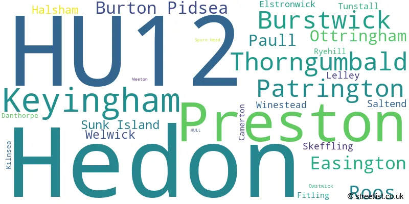
The largest settlement in the HU12 postal code is Hedon followed by Patrington, and Preston.
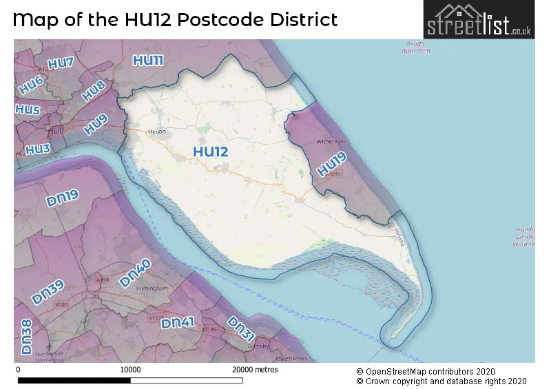
The postcode area has a boundary with The North Sea and The Humber.
The HU12 Postcode shares a border with HU19 (WITHERNSEA, Hollym, Waxholme), HU9 (HULL) and HU11 (Bilton, Aldbrough, Sproatley).
In the HU12 postcode district, the primary settlement is Easington. Other significant settlements in this district include Halsham, Kilnsea, Ottringham, Owstwick, Patrington, Roos, Skeffling, Spurn Head, Sunk Island, Tunstall, Weeton, Welwick, and Winestead. The postal town with the highest number of postcodes in this district is Hull, which is located in the East Riding of Yorkshire in England.
For the district HU12, we have data on 3 postcode sectors. Here's a breakdown: The sector HU12 0, covers Patrington and Roos and Easington and Ottringham in East Riding of Yorkshire. The sector HU12 8, covers Hedon and Preston in East Riding of Yorkshire. The sector HU12 9, covers Keyingham and Thorngumbald and Burstwick and Burton Pidsea in East Riding of Yorkshire.

Map of the HU12 Postcode District
Explore the HU12 postcode district by using our free interactive map.
When it comes to local government, postal geography often disregards political borders. However, for a breakdown in the HU12 District: the district mostly encompasses the East Riding of Yorkshire area with a total of 769 postcodes.
Recent House Sales in HU12
| Date | Price | Address |
|---|---|---|
| 18/10/2023 | £155,000 | Adeliza Garth, Hedon, Hull, HU12 8NB |
| 29/09/2023 | £261,000 | South End Road, Ottringham, Hull, HU12 0DP |
| 18/09/2023 | £167,000 | Greville Road, Hedon, Hull, HU12 8DP |
| 14/09/2023 | £100,000 | Thorn Road, Hedon, Hull, HU12 8GY |
| 04/09/2023 | £285,000 | Fitling Lane, Fitling, Hull, HU12 9AL |
| 25/08/2023 | £275,000 | Enholmes Lane, Patrington, Hull, HU12 0PR |
| 24/08/2023 | £145,000 | Cedar Court, Hedon, Hull, HU12 8XL |
| 21/08/2023 | £200,000 | Nettleton Garth, Burstwick, Hull, HU12 9DY |
| 21/08/2023 | £136,000 | Beech Close, Burstwick, Hull, HU12 9HN |
| 18/08/2023 | £165,000 | Westerdale Close, Keyingham, Hull, HU12 9TT |
Weather Forecast for HU12
Press Button to Show Forecast for Keyingham
| Time Period | Icon | Description | Temperature | Rain Probability | Wind |
|---|---|---|---|---|---|
| 03:00 to 06:00 | Cloudy | 2.0°C (feels like -1.0°C) | 4.00% | NW 7 mph | |
| 06:00 to 09:00 | Cloudy | 4.0°C (feels like 1.0°C) | 4.00% | NNW 7 mph | |
| 09:00 to 12:00 | Cloudy | 7.0°C (feels like 5.0°C) | 11.00% | NE 7 mph | |
| 12:00 to 15:00 | Light rain shower (day) | 8.0°C (feels like 6.0°C) | 30.00% | E 7 mph | |
| 15:00 to 18:00 | Cloudy | 8.0°C (feels like 6.0°C) | 8.00% | ENE 9 mph | |
| 18:00 to 21:00 | Partly cloudy (day) | 7.0°C (feels like 5.0°C) | 4.00% | E 9 mph | |
| 21:00 to 00:00 | Cloudy | 5.0°C (feels like 2.0°C) | 4.00% | E 7 mph |
Press Button to Show Forecast for Keyingham
| Time Period | Icon | Description | Temperature | Rain Probability | Wind |
|---|---|---|---|---|---|
| 00:00 to 03:00 | Cloudy | 4.0°C (feels like 2.0°C) | 6.00% | E 7 mph | |
| 03:00 to 06:00 | Cloudy | 4.0°C (feels like 1.0°C) | 9.00% | ENE 7 mph | |
| 06:00 to 09:00 | Cloudy | 6.0°C (feels like 4.0°C) | 9.00% | ENE 7 mph | |
| 09:00 to 12:00 | Partly cloudy (day) | 9.0°C (feels like 6.0°C) | 7.00% | E 11 mph | |
| 12:00 to 15:00 | Cloudy | 9.0°C (feels like 7.0°C) | 14.00% | ENE 11 mph | |
| 15:00 to 18:00 | Cloudy | 9.0°C (feels like 7.0°C) | 13.00% | ENE 13 mph | |
| 18:00 to 21:00 | Cloudy | 8.0°C (feels like 5.0°C) | 10.00% | ENE 13 mph | |
| 21:00 to 00:00 | Cloudy | 8.0°C (feels like 4.0°C) | 13.00% | ENE 13 mph |
Press Button to Show Forecast for Keyingham
| Time Period | Icon | Description | Temperature | Rain Probability | Wind |
|---|---|---|---|---|---|
| 00:00 to 03:00 | Cloudy | 8.0°C (feels like 4.0°C) | 18.00% | NE 13 mph | |
| 03:00 to 06:00 | Light rain | 8.0°C (feels like 4.0°C) | 51.00% | NE 16 mph | |
| 06:00 to 09:00 | Heavy rain | 8.0°C (feels like 5.0°C) | 77.00% | ENE 16 mph | |
| 09:00 to 12:00 | Light rain | 10.0°C (feels like 7.0°C) | 58.00% | ENE 13 mph | |
| 12:00 to 15:00 | Light rain shower (day) | 11.0°C (feels like 8.0°C) | 42.00% | ENE 13 mph | |
| 15:00 to 18:00 | Heavy rain shower (day) | 10.0°C (feels like 7.0°C) | 62.00% | NE 16 mph | |
| 18:00 to 21:00 | Light rain shower (day) | 9.0°C (feels like 7.0°C) | 40.00% | SSW 11 mph | |
| 21:00 to 00:00 | Cloudy | 8.0°C (feels like 5.0°C) | 11.00% | SSW 11 mph |
Where is the HU12 Postcode District?
The postcode district HU12 is located in Hull, a town in East Yorkshire. It is nearby several towns, including Withernsea to the east (4.8 miles away), Immingham to the southwest (8.3 miles away), Grimsby to the south (10.1 miles away), Barrow-upon-Humber to the west (12.2 miles away), and Hornsea to the north (14.7 miles away). Additionally, HU12 is approximately 152.2 miles away from the center of London.
The district is within the post town of HULL.
The sector has postcodes within the nation of England.
The HU12 Postcode District is covers the following regions.
- East Riding of Yorkshire - East Yorkshire and Northern Lincolnshire - Yorkshire and The Humber
- Kingston upon Hull, City of - East Yorkshire and Northern Lincolnshire - Yorkshire and The Humber
| Postcode Sector | Delivery Office |
|---|---|
| HU12 0 | Patrington Scale Payment Delivery Office |
| HU12 0 | Burton Pidsea Scale Payment Delivery Office |
| HU12 8 | Hull City Delivery Office |
| HU12 9 | Hull City Delivery Office |
| HU12 9 | Keyingham Scale Payment Delivery Office |
| HU12 9 | Thorngumbald Scale Payment Delivery Office |
| HU12 9 | Burton Pidsea Scale Payment Delivery Office |
| H | U | 1 | 2 | - | X | X | X |
| H | U | 1 | 2 | Space | Numeric | Letter | Letter |
Tourist Attractions within the Postcode Area
We found 1 visitor attractions within the HU12 postcode area
| Spurn Point |
|---|
| Wildlife |
| Nature Reserve / Wetlands / Wildlife Trips |
| View Spurn Point on Google Maps |
Current Monthly Rental Prices
| # Bedrooms | Min Price | Max Price | Avg Price |
|---|---|---|---|
| £460 | £460 | £460 | |
| 1 | £680 | £680 | £680 |
| 2 | £675 | £675 | £675 |
| 3 | £725 | £725 | £725 |
| 4 | £820 | £820 | £820 |
| 6 | £3,000 | £3,000 | £3,000 |
Current House Prices
| # Bedrooms | Min Price | Max Price | Avg Price |
|---|---|---|---|
| £150,000 | £550,000 | £380,000 | |
| 1 | £179,998 | £179,998 | £179,998 |
| 2 | £98,995 | £299,998 | £157,805 |
| 3 | £79,000 | £575,000 | £232,882 |
| 4 | £145,000 | £900,000 | £337,163 |
| 5 | £325,000 | £870,000 | £498,461 |
| 6 | £320,000 | £950,000 | £630,000 |
| 7 | £750,000 | £750,000 | £750,000 |
Estate Agents who Operate in the HU12 District
| Logo | Name | Brand Name | Address | Contact Number | Total Properties |
|---|---|---|---|---|---|
 | Hedon | Beercocks | 1 St. Augustines Gate, Hedon, HU12 8EU | 01482 424883 | 61 |
 | Withernsea | Goodwin Fox | 181 Queen Street Withernsea HU19 2JR | 01964 775821 | 21 |
 | Sutton-on-Hull | Whitakers | 86 Church Street, Sutton-On-Hull, Hull, HU7 4TD | 01482 251726 | 12 |
 | covering Hull | Purplebricks | Suite 7 First Floor Cranmore Drive Shirley Solihull B90 4RZ | 020 3907 3358 | 10 |
 | Hull | Reeds Rains | 508 Holderness Road, Hull, HU9 3DS | 01482 251835 | 10 |
| Type of Property | 2018 Average | 2018 Sales | 2017 Average | 2017 Sales | 2016 Average | 2016 Sales | 2015 Average | 2015 Sales |
|---|---|---|---|---|---|---|---|---|
| Detached | £221,587 | 169 | £231,991 | 156 | £216,378 | 160 | £205,190 | 159 |
| Semi-Detached | £144,069 | 172 | £136,613 | 215 | £124,655 | 214 | £124,532 | 170 |
| Terraced | £114,092 | 113 | £112,385 | 73 | £101,106 | 79 | £99,909 | 74 |
| Flats | £80,306 | 8 | £91,633 | 15 | £88,004 | 19 | £90,787 | 13 |