The IP17 2 postcode sector is within the county of Suffolk.
Did you know? According to the 2021 Census, the IP17 2 postcode sector is home to a bustling 2,584 residents!
Given that each sector allows for 400 unique postcode combinations. Letters C, I, K, M, O and V are not allowed in the last two letters of a postcode. With 196 postcodes already in use, this leaves 204 units available.
The largest settlement in the IP17 2 postal code is Kelsale followed by Peasenhall, and Sibton.
The IP17 2 Postcode shares a border with IP13 8 (Laxfield, Badingham, Dennington), IP13 9 (Framlingham, Parham, Saxtead), IP16 4 (LEISTON, Thorpeness, Aldringham), IP17 1 (SAXMUNDHAM, Snape, Knodishall), IP17 3 (Yoxford, Westleton, Middleton), IP19 0 (Cratfield, Chediston, Wissett) and IP19 9 (Wenhaston, Bramfield, Blythburgh).
The sector is within the post town of SAXMUNDHAM.
IP17 2 is a postcode sector within the IP17 postcode district which is within the IP Ipswich postcode area.
The Royal Mail delivery office for the IP17 2 postal sector is the Saxmundham Delivery Office and Peasenhall Scale Payment Delivery Office.
The area of the IP17 2 postcode sector is 23.44 square miles which is 60.70 square kilometres or 14,999.08 square acres.
Waterways within the IP17 2 postcode sector include the Yox, River Fromus, River Yox, Alde.

Map of the IP17 2 Postcode Sector
Explore the IP17 2 postcode sector by using our free interactive map.
| I | P | 1 | 7 | - | 2 | X | X |
| I | P | 1 | 7 | Space | 2 | Letter | Letter |
Official List of Streets
Sibton (9 Streets)
Kelsale (24 Streets)
Peasenhall (20 Streets)
Rendham (3 Streets)
Carlton (7 Streets)
Bruisyard (7 Streets)
Sweffling (5 Streets)
SAXMUNDHAM (1 Streets)
Unofficial Streets or Alternative Spellings
Knodishall
THE GREENMiddleton
FORDLEY ROAD HAWTHORN ROADWalpole
PEASENHALL ROADBadingham
BRUISYARD ROAD HIGH ROAD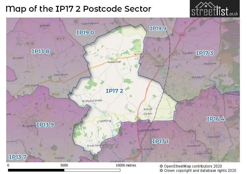
House Prices in the IP17 2 Postcode Sector
| Type of Property | 2018 Average | 2018 Sales | 2017 Average | 2017 Sales | 2016 Average | 2016 Sales | 2015 Average | 2015 Sales |
|---|---|---|---|---|---|---|---|---|
| Detached | £539,213 | 13 | £423,421 | 19 | £464,594 | 13 | £430,965 | 23 |
| Semi-Detached | £243,167 | 6 | £311,875 | 4 | £249,591 | 11 | £180,357 | 7 |
| Terraced | £283,500 | 4 | £184,286 | 7 | £195,000 | 8 | £260,833 | 3 |
| Flats | £0 | 0 | £250,000 | 1 | £0 | 0 | £130,000 | 1 |
Important Postcodes IP17 2 in the Postcode Sector
IP17 2NP is the postcode for Kelsale Primary School, Carlton Road, and Kelsale Primary School, Carlton Road, Kelsale
| The IP17 2 Sector is within these Local Authorities |
|
|---|---|
| The IP17 2 Sector is within these Counties |
|
| The IP17 2 Sector is within these Water Company Areas |
|