The IP33 1 postcode sector is within the county of Suffolk.
Did you know? According to the 2021 Census, the IP33 1 postcode sector is home to a bustling 4,693 residents!
Given that each sector allows for 400 unique postcode combinations. Letters C, I, K, M, O and V are not allowed in the last two letters of a postcode. With 180 postcodes already in use, this leaves 220 units available.
The IP33 1 postal code covers the settlement of BURY ST. EDMUNDS.
The IP33 1 Postcode shares a border with IP33 2 (BURY ST. EDMUNDS), IP33 3 (BURY ST. EDMUNDS, Westley), IP32 6 (BURY ST. EDMUNDS) and IP32 7 (BURY ST. EDMUNDS).
The sector is within the post town of BURY ST. EDMUNDS.
IP33 1 is a postcode sector within the IP3 postcode district which is within the IP Ipswich postcode area.
The Royal Mail delivery office for the IP33 1 postal sector is the unknown.
The area of the IP33 1 postcode sector is 0.57 square miles which is 1.49 square kilometres or 367.23 square acres.
The IP33 1 postcode sector is crossed by the A14 Major A road.
Waterways within the IP33 1 postcode sector include the Lark.

Map of the IP33 1 Postcode Sector
Explore the IP33 1 postcode sector by using our free interactive map.
| I | P | 3 | 3 | - | 1 | X | X |
| I | P | 3 | 3 | Space | 1 | Letter | Letter |
Official List of Streets
BURY ST. EDMUNDS (81 Streets)
Unofficial Streets or Alternative Spellings
BURY ST. EDMUNDS
EASTERN WAY GOSNOLD STREET HOUGHTON WAY MOUNT ROAD NORTHGATE LODGE PARKWAY RISBYGATE STREET ROUGHAM ROAD SHIREHALL WAY SPRINGFIELD ROAD VINEFIELDS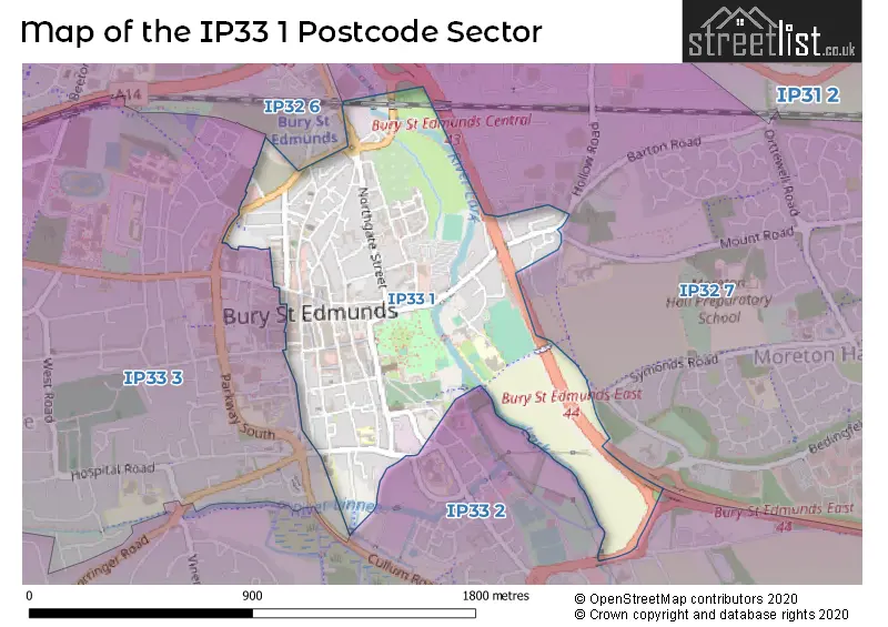
House Prices in the IP33 1 Postcode Sector
| Type of Property | 2018 Average | 2018 Sales | 2017 Average | 2017 Sales | 2016 Average | 2016 Sales | 2015 Average | 2015 Sales |
|---|---|---|---|---|---|---|---|---|
| Detached | £727,070 | 10 | £397,143 | 7 | £0 | 0 | £562,083 | 6 |
| Semi-Detached | £472,694 | 18 | £389,667 | 6 | £336,778 | 9 | £308,080 | 7 |
| Terraced | £312,708 | 66 | £349,904 | 58 | £320,123 | 85 | £284,015 | 72 |
| Flats | £223,032 | 31 | £244,648 | 30 | £233,628 | 35 | £210,359 | 44 |
Important Postcodes IP33 1 in the Postcode Sector
IP33 1AA is the postcode for Post Office, 17-18 Cornhill
IP33 1AE is the postcode for The Swan Surgery, Northgate Business Park
IP33 1DX is the postcode for Moyse's Hall Museum, 40 Cornhill
IP33 1ET is the postcode for Guildhall Surgery, Lower Baxter Street
IP33 1HE is the postcode for Bloomfield House, Looms Lane
IP33 1HF is the postcode for Bury St Edmunds Magistrates & Crown Court, Old Shire Hall
IP33 1LU is the postcode for Angel Hill Surgery, 1 Angel Hill
IP33 1LY is the postcode for The Athenaeum, Athenaeum Lane, and The Athenaeum, Angel Hill
IP33 1QG is the postcode for St EdmundG��s Catholic Pre-school & Sunshine Club, Westgate Street, ST. EDMUNDS RC PRIMARY SCHOOL NEW CLASSROOM BLOCK, St. Edmunds RC Primary School, Westgate Street, and St. Edmunds RC Primary School, Westgate Street
IP33 1RE is the postcode for NEW TEACHING BLOCK, Guildhall Feoffment Community Primary School, Bridewell Lane, Guildhall Feoffment Cp School, Bridewell Lane, GUILDHALL FEOFFMENT COMMUNITY PRIMARY SCHOOL, BRIDEWELL LANE, BURY ST EDMUNDS, and Guildhall Feoffment Community Primary School, Bridewell Lane
IP33 1RX is the postcode for New Shire Hall, Raingate Street, and Suffolk County Council, Raingate Street, New Shire Hall
IP33 1TR is the postcode for Bury St Edmunds County Court and Family Court, Triton House, St Andrew's Street North, and High Court District Registry & County Court Offices, Triton House, St. Andrews Street North
IP33 1TT is the postcode for St Andrews House, St Andrews Street North, and St. Andrews House, St. Andrews Street North
IP33 1TZ is the postcode for HM Revenue & Customs, Triton House, Suffolk County Council, Bury St. Edmunds Library Sargents Walk, St. Andrews Street North, and Bus Station, St. Andrews Street North
IP33 1UN is the postcode for Corn Exchange, Abbeygate Street
IP33 1UZ is the postcode for SENDAT Angel Hill, Priory School, Angel Hill College
IP33 1XB is the postcode for St. Edmundsbury Borough Council, Borough Offices, Angel Hill
IP33 1YB is the postcode for St. James Middle School, Vinefields
| The IP33 1 Sector is within these Local Authorities |
|
|---|---|
| The IP33 1 Sector is within these Counties |
|
| The IP33 1 Sector is within these Water Company Areas |
|