Given that each sector allows for 400 unique postcode combinations. Letters C, I, K, M, O and V are not allowed in the last two letters of a postcode. With 199 postcodes already in use, this leaves 201 units available.
The largest settlement in the KA5 5 postal code is MAUCHLINE followed by Tarbolton, and Stair.
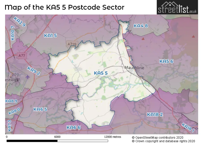
The KA5 5 Postcode shares a border with KA6 5 (Mossblown, Annbank, St. Quivox), KA9 2 (PRESTWICK, Monkton, Glasgow Prestwick Intnl Airport), KA1 5 (Hurlford, Symington, KILMARNOCK), KA4 8 (GALSTON, Moscow), KA5 6 (MAUCHLINE, Catrine, Sorn), KA6 6 (Coylton, Dalrymple, AYR) and KA18 2 (Auchinleck, Ochiltree, CUMNOCK).
The sector is within the post town of MAUCHLINE.
KA5 5 is a postcode sector within the KA5 postcode district which is within the KA Kilmarnock postcode area.
The Royal Mail delivery office for the KA5 5 postal sector is the Cumnock Delivery Office.
The area of the KA5 5 postcode sector is 29.57 square miles which is 76.60 square kilometres or 18,927.92 square acres.


Map of the KA5 5 Postcode Sector
Explore the KA5 5 postcode sector by using our free interactive map.
| K | A | 5 | - | 5 | X | X |
| K | A | 5 | Space | 5 | Letter | Letter |
Official List of Streets
Tarbolton (31 Streets)
MAUCHLINE (39 Streets)
Unofficial Streets or Alternative Spellings
| The KA5 5 Sector is within these Local Authorities | |
|---|---|
| The KA5 5 Sector is within these Counties | |
| The KA5 5 Sector is within these Water Company Areas |