Given that each sector allows for 400 unique postcode combinations. Letters C, I, K, M, O and V are not allowed in the last two letters of a postcode. With 49 postcodes already in use, this leaves 351 units available.
The largest settlement in the KW12 6 postal code is HALKIRK followed by Altnabreac, and Westerdale.
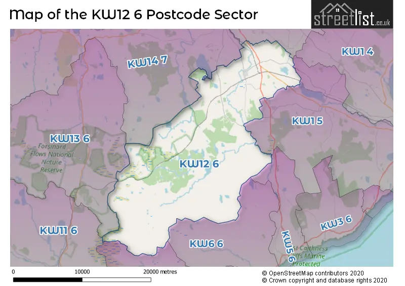
The KW12 6 Postcode shares a border with KW1 5 (WICK, Watten, Thrumster), KW14 7 (THURSO, Scrabster, Bettyhill), KW14 8 (THURSO, Castletown, Dunnet), KW5 6 (LATHERON, Latheronwheel), KW6 6 (DUNBEATH, Braemore, Knockally), KW7 6 (BERRIEDALE), KW11 6 (KINBRACE, Strathnaver) and KW13 6 (FORSINARD).
The sector is within the post town of HALKIRK.
KW12 6 is a postcode sector within the KW12 postcode district which is within the KW Kirkwall postcode area.
The Royal Mail delivery office for the KW12 6 postal sector is the Halkirk Scale Payment Delivery Office.
The area of the KW12 6 postcode sector is 161.89 square miles which is 419.31 square kilometres or 103,612.70 square acres.


Map of the KW12 6 Postcode Sector
Explore the KW12 6 postcode sector by using our free interactive map.
| K | W | 1 | 2 | - | 6 | X | X |
| K | W | 1 | 2 | Space | 6 | Letter | Letter |
Official List of Streets
HALKIRK (20 Streets)
Unofficial Streets or Alternative Spellings
| The KW12 6 Sector is within these Local Authorities | |
|---|---|
| The KW12 6 Sector is within these Counties | |
| The KW12 6 Sector is within these Water Company Areas |