The L10 2 postcode sector is within the county of Merseyside.
Did you know? According to the 2021 Census, the L10 2 postcode sector is home to a bustling 1,159 residents!
Given that each sector allows for 400 unique postcode combinations. Letters C, I, K, M, O and V are not allowed in the last two letters of a postcode. With 27 postcodes already in use, this leaves 373 units available.
The largest settlements in the L10 2 postal code are LIVERPOOL and Old Roan.
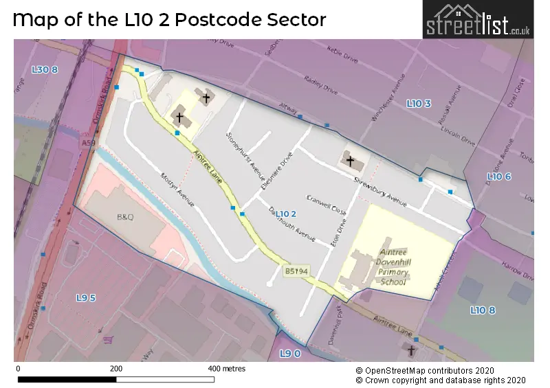
The L10 2 Postcode shares a border with L9 5 (LIVERPOOL, Aintree Racecourse Retail & Bus Pk), L9 0 (LIVERPOOL, Walton), L10 3 (LIVERPOOL, Aintree), L10 6 (LIVERPOOL, Aintree, Old Roan) and L10 8 (LIVERPOOL, Aintree).
The sector is within the post town of LIVERPOOL.
L10 2 is a postcode sector within the L1 postcode district which is within the L Liverpool postcode area.
The Royal Mail delivery office for the L10 2 postal sector is the Liverpool 1-3.
The area of the L10 2 postcode sector is 0.10 square miles which is 0.27 square kilometres or 65.84 square acres.
Waterways within the L10 2 postcode sector include the Leeds and Liverpool Canal.

Map of the L10 2 Postcode Sector
Explore the L10 2 postcode sector by using our free interactive map.
| L | 1 | 0 | - | 2 | X | X |
| L | 1 | 0 | Space | 2 | Letter | Letter |
Official List of Streets
LIVERPOOL (11 Streets)
Old Roan (2 Streets)
Unofficial Streets or Alternative Spellings
LIVERPOOL
ATHOLL CRESCENT DAVENHILL PARK DENSTONE AVENUE HARROW DRIVE ORMSKIRK ROAD CLIFTON DRIVEAintree
WINCHESTER AVENUEBOOTLE
COPY LANEWeather Forecast for L10 2
Press Button to Show Forecast for Aintree
| Time Period | Icon | Description | Temperature | Rain Probability | Wind |
|---|---|---|---|---|---|
| 00:00 to 03:00 | Cloudy | 11.0°C (feels like 8.0°C) | 9.00% | SSE 13 mph | |
| 03:00 to 06:00 | Cloudy | 10.0°C (feels like 7.0°C) | 7.00% | SE 16 mph | |
| 06:00 to 09:00 | Cloudy | 10.0°C (feels like 6.0°C) | 4.00% | SE 16 mph | |
| 09:00 to 12:00 | Cloudy | 12.0°C (feels like 9.0°C) | 5.00% | SE 18 mph | |
| 12:00 to 15:00 | Cloudy | 15.0°C (feels like 11.0°C) | 8.00% | SSE 18 mph | |
| 15:00 to 18:00 | Cloudy | 15.0°C (feels like 12.0°C) | 14.00% | SSE 16 mph | |
| 18:00 to 21:00 | Cloudy | 13.0°C (feels like 11.0°C) | 15.00% | SSE 11 mph | |
| 21:00 to 00:00 | Cloudy | 12.0°C (feels like 10.0°C) | 15.00% | SE 9 mph |
Press Button to Show Forecast for Aintree
| Time Period | Icon | Description | Temperature | Rain Probability | Wind |
|---|---|---|---|---|---|
| 00:00 to 03:00 | Cloudy | 11.0°C (feels like 9.0°C) | 9.00% | SE 9 mph | |
| 03:00 to 06:00 | Cloudy | 10.0°C (feels like 8.0°C) | 5.00% | SE 7 mph | |
| 06:00 to 09:00 | Cloudy | 9.0°C (feels like 8.0°C) | 4.00% | SE 7 mph | |
| 09:00 to 12:00 | Cloudy | 12.0°C (feels like 10.0°C) | 5.00% | ESE 7 mph | |
| 12:00 to 15:00 | Cloudy | 14.0°C (feels like 13.0°C) | 7.00% | SSE 7 mph | |
| 15:00 to 18:00 | Cloudy | 15.0°C (feels like 14.0°C) | 10.00% | NNW 7 mph | |
| 18:00 to 21:00 | Cloudy | 14.0°C (feels like 12.0°C) | 11.00% | NW 7 mph | |
| 21:00 to 00:00 | Cloudy | 12.0°C (feels like 11.0°C) | 10.00% | NNW 9 mph |
Press Button to Show Forecast for Aintree
| Time Period | Icon | Description | Temperature | Rain Probability | Wind |
|---|---|---|---|---|---|
| 00:00 to 03:00 | Cloudy | 11.0°C (feels like 10.0°C) | 11.00% | N 7 mph | |
| 03:00 to 06:00 | Cloudy | 11.0°C (feels like 9.0°C) | 8.00% | N 7 mph | |
| 06:00 to 09:00 | Cloudy | 11.0°C (feels like 10.0°C) | 6.00% | N 7 mph | |
| 09:00 to 12:00 | Partly cloudy (day) | 13.0°C (feels like 11.0°C) | 4.00% | N 9 mph | |
| 12:00 to 15:00 | Sunny day | 15.0°C (feels like 14.0°C) | 3.00% | N 11 mph | |
| 15:00 to 18:00 | Partly cloudy (day) | 17.0°C (feels like 14.0°C) | 3.00% | N 11 mph | |
| 18:00 to 21:00 | Sunny day | 16.0°C (feels like 13.0°C) | 3.00% | N 11 mph | |
| 21:00 to 00:00 | Clear night | 13.0°C (feels like 11.0°C) | 3.00% | NNE 11 mph |
House Prices in the L10 2 Postcode Sector
| Type of Property | 2018 Average | 2018 Sales | 2017 Average | 2017 Sales | 2016 Average | 2016 Sales | 2015 Average | 2015 Sales |
|---|---|---|---|---|---|---|---|---|
| Detached | £0 | 0 | £0 | 0 | £0 | 0 | £163,000 | 1 |
| Semi-Detached | £177,180 | 23 | £166,941 | 17 | £156,207 | 14 | £147,104 | 14 |
| Terraced | £0 | 0 | £0 | 0 | £158,000 | 1 | £0 | 0 |
| Flats | £0 | 0 | £0 | 0 | £0 | 0 | £0 | 0 |
| The L10 2 Sector is within these Local Authorities |
|
|---|---|
| The L10 2 Sector is within these Counties |
|
| The L10 2 Sector is within these Water Company Areas |
|