The L3 2 postcode sector is within the county of Merseyside.
Did you know? According to the 2021 Census, the L3 2 postcode sector is home to a bustling 3,192 residents!
Given that each sector allows for 400 unique postcode combinations. Letters C, I, K, M, O and V are not allowed in the last two letters of a postcode. With 44 postcodes already in use, this leaves 356 units available.
The L3 2 postal code covers the settlement of LIVERPOOL.
The L3 2 Postcode shares a border with L2 2 (LIVERPOOL), L3 3 (LIVERPOOL), L1 6 (LIVERPOOL), L3 8 (LIVERPOOL) and L3 6 (LIVERPOOL).
The sector is within the post town of LIVERPOOL.
L3 2 is a postcode sector within the L3 postcode district which is within the L Liverpool postcode area.
The Royal Mail delivery office for the L3 2 postal sector is the Liverpool 1-3.
The area of the L3 2 postcode sector is 0.07 square miles which is 0.18 square kilometres or 45.04 square acres.

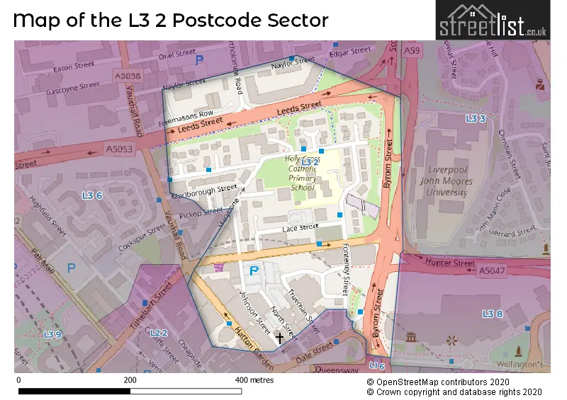
Map of the L3 2 Postcode Sector
Explore the L3 2 postcode sector by using our free interactive map.
| L | 3 | - | 2 | X | X |
| L | 3 | Space | 2 | Letter | Letter |
Official List of Streets
LIVERPOOL (25 Streets)
Unofficial Streets or Alternative Spellings
Schools and Places of Education Within the L3 2 Postcode Sector
Holy Cross Catholic Primary School
Voluntary aided school
Fontenoy Street, Liverpool, Merseyside, L3 2DU
Head: Mrs Helen Bannon
Ofsted Rating: Good
Inspection: 2023-03-31 (424 days ago)
Website: Visit Holy Cross Catholic Primary School Website
Phone: 01512369505
Number of Pupils: 188
House Prices in the L3 2 Postcode Sector
| Type of Property | 2018 Average | 2018 Sales | 2017 Average | 2017 Sales | 2016 Average | 2016 Sales | 2015 Average | 2015 Sales |
|---|---|---|---|---|---|---|---|---|
| Detached | £0 | 0 | £0 | 0 | £0 | 0 | £0 | 0 |
| Semi-Detached | £0 | 0 | £0 | 0 | £0 | 0 | £0 | 0 |
| Terraced | £130,000 | 1 | £0 | 0 | £115,000 | 1 | £0 | 0 |
| Flats | £134,837 | 38 | £128,090 | 38 | £116,508 | 46 | £108,979 | 65 |
Important Postcodes L3 2 in the Postcode Sector
L3 2AA is the postcode for Liverpool City Council, Premier Court
L3 2AB is the postcode for 70 Great Crosshall Street, and Liverpool John Moores University, 70 Great Crosshall Street
L3 2AJ is the postcode for Liverpool John Moores University, Kingsway House, Hatton Garden
L3 2AN is the postcode for Merseytravel, 24 Hatton Garden
L3 2AY is the postcode for The National Museum, 15 North Street, and Centre for Public Health, Castle House, North Street
L3 2BG is the postcode for Marybone Health Centre, 2 Vauxhall Road
L3 2BR is the postcode for Liverpool Museums, North Street Warehouse
L3 2BT is the postcode for Liverpool John Moores University, Marybone Lecture Theatre
L3 2BY is the postcode for 2 Marybone
L3 2DU is the postcode for Holy Cross Catholic Primary School, Fontenoy Street, HOLY CROSS CATHOLIC PRIMARY SCHOOL, FONTENOY STREET, LIVERPOOL, and Holy Cross & St. Marys Primary School, Fontenoy Street
L3 2ET is the postcode for Henry Cotton Campus, 15-21 Webster Street, Liverpool John Moores University, Henry Cotton Campus, Trueman Street Building, 15-21 Webster Street, and Liverpool John Moores University, Henry Cotton Campus, Trueman Street Building
| The L3 2 Sector is within these Local Authorities |
|
|---|---|
| The L3 2 Sector is within these Counties |
|
| The L3 2 Sector is within these Water Company Areas |
|