The L30 0 postcode sector is within the county of Merseyside.
Did you know? According to the 2021 Census, the L30 0 postcode sector is home to a bustling 2,081 residents!
Given that each sector allows for 400 unique postcode combinations. Letters C, I, K, M, O and V are not allowed in the last two letters of a postcode. With 45 postcodes already in use, this leaves 355 units available.
The L30 0 postal code covers the settlement of BOOTLE.
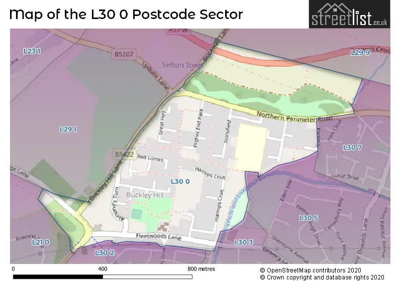
The L30 0 Postcode shares a border with L30 7 (BOOTLE), L29 1 (LIVERPOOL), L29 9 (LIVERPOOL, Sefton), L30 3 (BOOTLE), L21 0 (LIVERPOOL, Ford), L30 5 (BOOTLE) and L30 2 (BOOTLE).
The sector is within the post town of BOOTLE.
L30 0 is a postcode sector within the L3 postcode district which is within the L Liverpool postcode area.
The Royal Mail delivery office for the L30 0 postal sector is the Liverpool 1-3.
The area of the L30 0 postcode sector is 0.25 square miles which is 0.65 square kilometres or 160.19 square acres.
Waterways within the L30 0 postcode sector include the Leeds and Liverpool Canal.

Map of the L30 0 Postcode Sector
Explore the L30 0 postcode sector by using our free interactive map.
| L | 3 | 0 | - | 0 | X | X |
| L | 3 | 0 | Space | 0 | Letter | Letter |
Official List of Streets
BOOTLE (36 Streets)
Unofficial Streets or Alternative Spellings
LIVERPOOL
BRICKWALL LANEBOOTLE
NORTHERN PERIMETER ROAD ALMONDS TURN BROOMS CROSS ROAD PINFOLD CLOSE SAINT MONICAS DRIVE ST NICHOLAS DRIVEBOOTLE,
BUCKLEY HILL LANECrosby
EDGE LANEFord
GORSEY LANEThornton
LYDIATE LANESchools and Places of Education Within the L30 0 Postcode Sector
The Grange Primary School
Community school
Stonyfield, Bootle, Merseyside, L30 0QS
Head: Mr Daniel RG Hains
Ofsted Rating: Good
Inspection: 2023-07-04 (340 days ago)
Website: Visit The Grange Primary School Website
Phone: 01519247917
Number of Pupils: 280
House Prices in the L30 0 Postcode Sector
| Type of Property | 2018 Average | 2018 Sales | 2017 Average | 2017 Sales | 2016 Average | 2016 Sales | 2015 Average | 2015 Sales |
|---|---|---|---|---|---|---|---|---|
| Detached | £0 | 0 | £0 | 0 | £146,000 | 1 | £0 | 0 |
| Semi-Detached | £85,000 | 1 | £78,833 | 3 | £0 | 0 | £0 | 0 |
| Terraced | £76,953 | 16 | £76,250 | 8 | £77,158 | 18 | £64,607 | 15 |
| Flats | £0 | 0 | £0 | 0 | £63,500 | 1 | £18,500 | 2 |
Important Postcodes L30 0 in the Postcode Sector
L30 0QP is the postcode for James Dixon Court, Harrops Croft
L30 0QS is the postcode for Grange Primary School, Stonyfield
| The L30 0 Sector is within these Local Authorities |
|
|---|---|
| The L30 0 Sector is within these Counties |
|
| The L30 0 Sector is within these Water Company Areas |
|