The L30 8 postcode sector is within the county of Merseyside.
Did you know? According to the 2021 Census, the L30 8 postcode sector is home to a bustling 1,326 residents!
Given that each sector allows for 400 unique postcode combinations. Letters C, I, K, M, O and V are not allowed in the last two letters of a postcode. With 25 postcodes already in use, this leaves 375 units available.
The L30 8 postal code covers the settlement of BOOTLE.
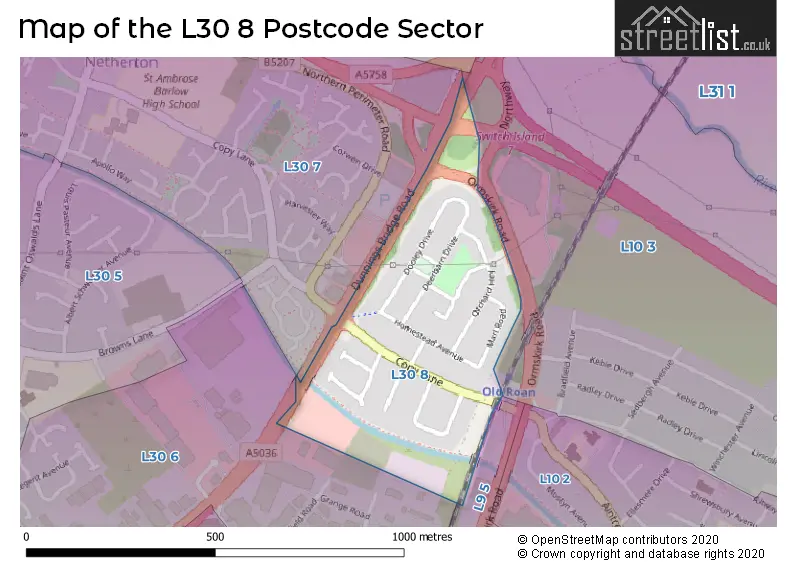
The L30 8 Postcode shares a border with L9 5 (LIVERPOOL, Aintree Racecourse Retail & Bus Pk), L30 6 (BOOTLE), L30 7 (BOOTLE) and L10 3 (LIVERPOOL, Aintree).
The sector is within the post town of BOOTLE.
L30 8 is a postcode sector within the L30 postcode district which is within the L Liverpool postcode area.
The Royal Mail delivery office for the L30 8 postal sector is the Bootle Delivery Office.
The area of the L30 8 postcode sector is 0.13 square miles which is 0.34 square kilometres or 84.86 square acres.
The L30 8 postcode sector is crossed by the A59 Major A road.
The L30 8 postcode sector is crossed by the A5036 Major A road.
Waterways within the L30 8 postcode sector include the Leeds and Liverpool Canal.

Map of the L30 8 Postcode Sector
Explore the L30 8 postcode sector by using our free interactive map.
| L | 3 | 0 | - | 8 | X | X |
| L | 3 | 0 | Space | 8 | Letter | Letter |
Official List of Streets
BOOTLE (14 Streets)
Unofficial Streets or Alternative Spellings
Weather Forecast for L30 8
Press Button to Show Forecast for Netherton
| Time Period | Icon | Description | Temperature | Rain Probability | Wind |
|---|---|---|---|---|---|
| 18:00 to 21:00 | Light rain | 12.0°C (feels like 10.0°C) | 49.00% | W 9 mph | |
| 21:00 to 00:00 | Light rain | 12.0°C (feels like 10.0°C) | 49.00% | SW 7 mph |
Press Button to Show Forecast for Netherton
| Time Period | Icon | Description | Temperature | Rain Probability | Wind |
|---|---|---|---|---|---|
| 00:00 to 03:00 | Light rain | 11.0°C (feels like 10.0°C) | 48.00% | SW 7 mph | |
| 03:00 to 06:00 | Light rain | 11.0°C (feels like 9.0°C) | 44.00% | SSW 7 mph | |
| 06:00 to 09:00 | Cloudy | 11.0°C (feels like 10.0°C) | 12.00% | SSW 7 mph | |
| 09:00 to 12:00 | Overcast | 12.0°C (feels like 11.0°C) | 11.00% | SSW 9 mph | |
| 12:00 to 15:00 | Cloudy | 14.0°C (feels like 12.0°C) | 9.00% | SW 9 mph | |
| 15:00 to 18:00 | Cloudy | 14.0°C (feels like 13.0°C) | 10.00% | NW 7 mph | |
| 18:00 to 21:00 | Cloudy | 13.0°C (feels like 12.0°C) | 10.00% | NW 7 mph | |
| 21:00 to 00:00 | Cloudy | 12.0°C (feels like 11.0°C) | 7.00% | NE 7 mph |
Press Button to Show Forecast for Netherton
| Time Period | Icon | Description | Temperature | Rain Probability | Wind |
|---|---|---|---|---|---|
| 00:00 to 03:00 | Cloudy | 11.0°C (feels like 10.0°C) | 8.00% | E 7 mph | |
| 03:00 to 06:00 | Cloudy | 10.0°C (feels like 9.0°C) | 9.00% | ESE 7 mph | |
| 06:00 to 09:00 | Cloudy | 11.0°C (feels like 10.0°C) | 9.00% | E 7 mph | |
| 09:00 to 12:00 | Cloudy | 13.0°C (feels like 12.0°C) | 9.00% | ESE 7 mph | |
| 12:00 to 15:00 | Cloudy | 14.0°C (feels like 13.0°C) | 11.00% | SE 7 mph | |
| 15:00 to 18:00 | Light rain shower (day) | 14.0°C (feels like 13.0°C) | 35.00% | SE 7 mph | |
| 18:00 to 21:00 | Partly cloudy (day) | 13.0°C (feels like 12.0°C) | 12.00% | N 7 mph | |
| 21:00 to 00:00 | Partly cloudy (night) | 12.0°C (feels like 11.0°C) | 9.00% | N 7 mph |
House Prices in the L30 8 Postcode Sector
| Type of Property | 2018 Average | 2018 Sales | 2017 Average | 2017 Sales | 2016 Average | 2016 Sales | 2015 Average | 2015 Sales |
|---|---|---|---|---|---|---|---|---|
| Detached | £0 | 0 | £0 | 0 | £0 | 0 | £0 | 0 |
| Semi-Detached | £142,400 | 5 | £133,994 | 9 | £119,563 | 8 | £122,166 | 11 |
| Terraced | £112,867 | 9 | £107,417 | 6 | £105,786 | 7 | £106,575 | 6 |
| Flats | £0 | 0 | £0 | 0 | £0 | 0 | £0 | 0 |
| The L30 8 Sector is within these Local Authorities |
|
|---|---|
| The L30 8 Sector is within these Counties |
|
| The L30 8 Sector is within these Water Company Areas |
|