The L34 1 postcode sector is within the county of Merseyside.
Did you know? According to the 2021 Census, the L34 1 postcode sector is home to a bustling 3,082 residents!
Given that each sector allows for 400 unique postcode combinations. Letters C, I, K, M, O and V are not allowed in the last two letters of a postcode. With 83 postcodes already in use, this leaves 317 units available.
The L34 1 postal code covers the settlement of PRESCOT.
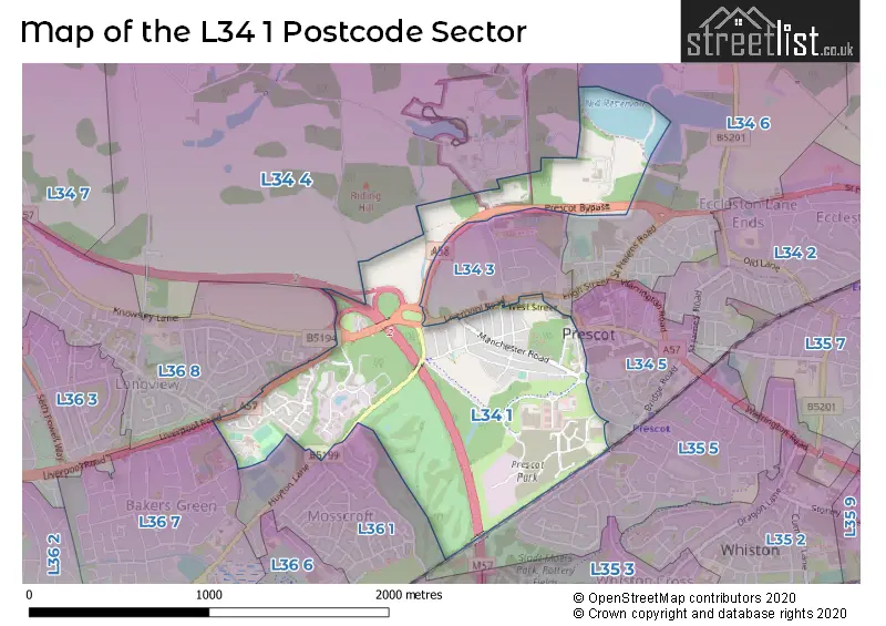
The L34 1 Postcode shares a border with L35 5 (PRESCOT, Whiston), L34 5 (PRESCOT), L34 6 (PRESCOT, Eccleston Lane Ends), L36 1 (LIVERPOOL, Huyton), L34 3 (PRESCOT), L34 4 (Knowsley, Knowsley Park), L36 7 (LIVERPOOL, Huyton) and L36 8 (LIVERPOOL, Huyton).
The sector is within the post town of PRESCOT.
L34 1 is a postcode sector within the L34 postcode district which is within the L Liverpool postcode area.
The Royal Mail delivery office for the L34 1 postal sector is the Prescot Delivery Office.
The area of the L34 1 postcode sector is 0.89 square miles which is 2.30 square kilometres or 567.63 square acres.
The L34 1 postcode sector is crossed by the M57 motorway.

Map of the L34 1 Postcode Sector
Explore the L34 1 postcode sector by using our free interactive map.
| L | 3 | 4 | - | 1 | X | X |
| L | 3 | 4 | Space | 1 | Letter | Letter |
Official List of Streets
PRESCOT (65 Streets)
Unofficial Streets or Alternative Spellings
House Prices in the L34 1 Postcode Sector
| Type of Property | 2018 Average | 2018 Sales | 2017 Average | 2017 Sales | 2016 Average | 2016 Sales | 2015 Average | 2015 Sales |
|---|---|---|---|---|---|---|---|---|
| Detached | £228,857 | 30 | £207,227 | 11 | £180,545 | 11 | £173,083 | 6 |
| Semi-Detached | £167,214 | 31 | £146,545 | 10 | £132,330 | 15 | £166,909 | 11 |
| Terraced | £139,625 | 4 | £136,000 | 2 | £54,500 | 2 | £0 | 0 |
| Flats | £0 | 0 | £0 | 0 | £0 | 0 | £0 | 0 |
Important Postcodes L34 1 in the Postcode Sector
L34 1AD is the postcode for Prescot Community Fire & Police Station, Manchester Road
L34 1ND is the postcode for Park House Medical Centre, Sewell Street
L34 1PJ is the postcode for Merseycare Nhs Trust, Kings Drive, Kings Business Park, Knowsley Housing Trust, Lakeview Kings Business Park, Kings Drive, Lakeview, Kings Drive, Kings Business Park, Unit 4, Puma Court, V7, Kings Business Park, Kings Drive, NHS Knowsley, Kings Business Park, Kings Drive, and V7, Kings Business Park
| The L34 1 Sector is within these Local Authorities |
|
|---|---|
| The L34 1 Sector is within these Counties |
|
| The L34 1 Sector is within these Water Company Areas |
|