The L37 2 postcode sector is within the county of Merseyside.
Did you know? According to the 2021 Census, the L37 2 postcode sector is home to a bustling 4,889 residents!
Given that each sector allows for 400 unique postcode combinations. Letters C, I, K, M, O and V are not allowed in the last two letters of a postcode. With 127 postcodes already in use, this leaves 273 units available.
The L37 2 postal code covers the settlement of Formby.
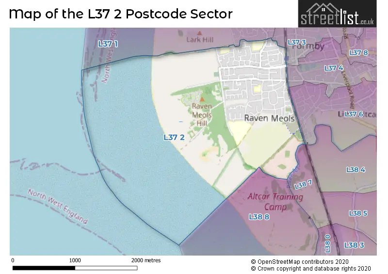
The L37 2 Postcode shares a border with L37 4 (Formby, LIVERPOOL), L37 6 (Formby), L38 7 (LIVERPOOL), L37 1 (Formby), L37 3 (Formby), L38 4 (Hightown) and L38 8 (LIVERPOOL).
The sector is within the post town of LIVERPOOL.
L37 2 is a postcode sector within the L37 postcode district which is within the L Liverpool postcode area.
The Royal Mail delivery office for the L37 2 postal sector is the Formby Delivery Office.
The area of the L37 2 postcode sector is 1.87 square miles which is 4.85 square kilometres or 1,198.19 square acres.
Waterways within the L37 2 postcode sector include the River Alt.

Map of the L37 2 Postcode Sector
Explore the L37 2 postcode sector by using our free interactive map.
| L | 3 | 7 | - | 2 | X | X |
| L | 3 | 7 | Space | 2 | Letter | Letter |
Official List of Streets
Formby (90 Streets)
LIVERPOOL (1 Streets)
Unofficial Streets or Alternative Spellings
Schools and Places of Education Within the L37 2 Postcode Sector
Range High School
Academy converter
Stapleton Road, Liverpool, Merseyside, L37 2YN
Head: Mr Michael McGarry
Ofsted Rating: Good
Inspection: 2022-03-23 (802 days ago)
Website: Visit Range High School Website
Phone: 01704879315
Number of Pupils: 1118
St Jerome's Catholic Primary School
Voluntary aided school
Greenloons Drive, Liverpool, Merseyside, L37 2LX
Head: Mrs Kathryn Monaghan
Ofsted Rating: Good
Inspection: 2023-04-19 (410 days ago)
Website: Visit St Jerome's Catholic Primary School Website
Phone: 01704833211
Number of Pupils: 203
St Luke's Church of England Primary School
Voluntary controlled school
Jubilee Road, Formby, Merseyside, L37 2HW
Head: Mrs Sharon Cowey
Ofsted Rating: Good
Inspection: 2018-04-11 (2244 days ago)
Website: Visit St Luke's Church of England Primary School Website
Phone: 01704872692
Number of Pupils: 372
Woodlands Primary School
Community school
Woodlands Road, Liverpool, Merseyside, L37 2JN
Head: Mr Keith Williams
Ofsted Rating: Good
Inspection: 2022-03-11 (814 days ago)
Website: Visit Woodlands Primary School Website
Phone: 01704876444
Number of Pupils: 374
House Prices in the L37 2 Postcode Sector
| Type of Property | 2018 Average | 2018 Sales | 2017 Average | 2017 Sales | 2016 Average | 2016 Sales | 2015 Average | 2015 Sales |
|---|---|---|---|---|---|---|---|---|
| Detached | £367,248 | 28 | £339,751 | 58 | £334,718 | 57 | £337,910 | 31 |
| Semi-Detached | £275,383 | 24 | £259,940 | 26 | £240,056 | 27 | £255,327 | 16 |
| Terraced | £0 | 0 | £208,750 | 2 | £160,000 | 1 | £221,502 | 3 |
| Flats | £0 | 0 | £0 | 0 | £0 | 0 | £165,500 | 2 |
Important Postcodes L37 2 in the Postcode Sector
L37 2HW is the postcode for St. Lukes C E Primary School, Jubilee Road
L37 2JN is the postcode for Woodlands Primary School, Woodlands Road
L37 2LX is the postcode for St. Jeromes RC Primary School, Greenloons Drive
L37 2YN is the postcode for SIXTH FORM, Range Academy, Stapleton Road, MAIN BUILDING, Range Academy, Stapleton Road, and Range Academy, Stapleton Road
| The L37 2 Sector is within these Local Authorities |
|
|---|---|
| The L37 2 Sector is within these Counties |
|
| The L37 2 Sector is within these Water Company Areas |
|