The L37 3 postcode sector is within the county of Merseyside.
Did you know? According to the 2021 Census, the L37 3 postcode sector is home to a bustling 4,530 residents!
Given that each sector allows for 400 unique postcode combinations. Letters C, I, K, M, O and V are not allowed in the last two letters of a postcode. With 111 postcodes already in use, this leaves 289 units available.
The L37 3 postal code covers the settlement of Formby.
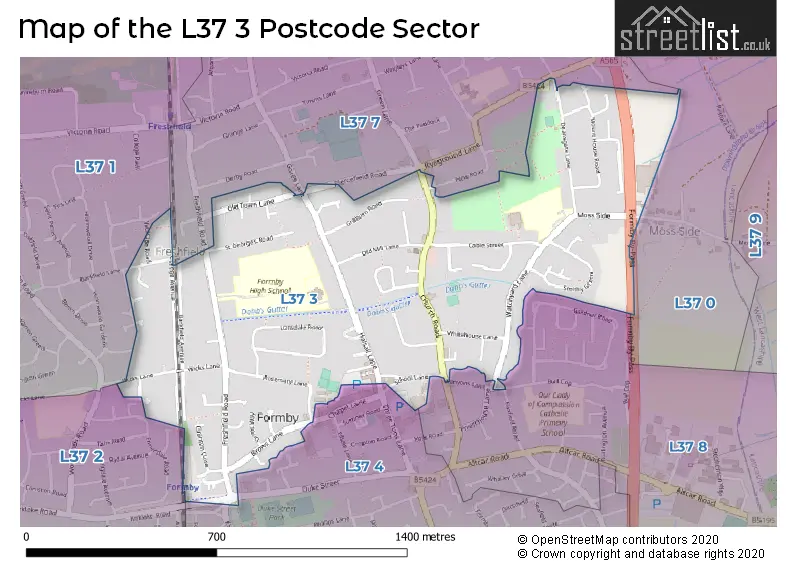
The L37 3 Postcode shares a border with L37 0 (Formby), L37 4 (Formby, LIVERPOOL), L37 1 (Formby), L37 2 (Formby), L37 7 (Formby) and L37 8 (Formby).
The sector is within the post town of LIVERPOOL.
L37 3 is a postcode sector within the L37 postcode district which is within the L Liverpool postcode area.
The Royal Mail delivery office for the L37 3 postal sector is the Formby Delivery Office.
The area of the L37 3 postcode sector is 0.59 square miles which is 1.53 square kilometres or 378.56 square acres.

Map of the L37 3 Postcode Sector
Explore the L37 3 postcode sector by using our free interactive map.
| L | 3 | 7 | - | 3 | X | X |
| L | 3 | 7 | Space | 3 | Letter | Letter |
Official List of Streets
Formby (55 Streets)
LIVERPOOL (1 Streets)
Unofficial Streets or Alternative Spellings
Schools and Places of Education Within the L37 3 Postcode Sector
Formby High School
Academy converter
Freshfield Road, Liverpool, Merseyside, L37 3HW
Head: Mr Alex Wood
Ofsted Rating: Good
Inspection: 2022-11-03 (576 days ago)
Website: Visit Formby High School Website
Phone: 01704873100
Number of Pupils: 1123
Freshfield Primary School
Community school
Watchyard Lane, Liverpool, Merseyside, L37 3JT
Head: Mrs Hayley Ward
Ofsted Rating: Outstanding
Inspection: 2013-06-07 (4012 days ago)
Website: Visit Freshfield Primary School Website
Phone: 01704876567
Number of Pupils: 276
House Prices in the L37 3 Postcode Sector
| Type of Property | 2018 Average | 2018 Sales | 2017 Average | 2017 Sales | 2016 Average | 2016 Sales | 2015 Average | 2015 Sales |
|---|---|---|---|---|---|---|---|---|
| Detached | £492,148 | 27 | £467,958 | 25 | £364,679 | 21 | £470,053 | 18 |
| Semi-Detached | £274,475 | 26 | £246,243 | 37 | £238,184 | 34 | £224,325 | 26 |
| Terraced | £189,688 | 4 | £203,375 | 8 | £244,500 | 7 | £154,375 | 4 |
| Flats | £164,999 | 27 | £203,043 | 38 | £139,636 | 18 | £119,706 | 18 |
Important Postcodes L37 3 in the Postcode Sector
L37 3HW is the postcode for FORMBY HIGH SCHOOL MAIN BUILDING, Formby Academy, Freshfield Road, FORMBY HIGH SCHOOL P BLOCK CRAFTS, Formby Academy, Freshfield Road, MAIN BUILDING, Formby Academy, Freshfield Road, FORMBY HIGH SCHOOL TOWER BLOCK 2 (L BLOCK) SCIENCE, Formby Academy, Freshfield Road, P BLOCK CRAFTS, Formby Academy, Freshfield Road, FORMBY HIGH SCHOOL TOWER BLOCK 1 (C BLOCK), Formby Academy, Freshfield Road, TOWER BLOCK 2 (L BLOCK) SCIENCE, Formby Academy, Freshfield Road, SIXTH FORM, Formby Academy, Freshfield Road, and FORMBY HIGH SCHOOL S BLOCK, Formby Academy, Freshfield Road
L37 3JT is the postcode for INFANT BLOCK, Freshfield Primary School & Children's Centre, Watchyard Lane, Freshfield Primary School & Children's Centre, Watchyard Lane, and JUNIOR BLOCK, Freshfield Primary School & Children's Centre, Watchyard Lane
L37 3NH is the postcode for Merseyside Fire & Rescue Service, Fire Station, Church Road
L37 3NY is the postcode for Oakfield Centre, Gores Lane, and Impact - Oakfield Centre, Gores Lane
| The L37 3 Sector is within these Local Authorities |
|
|---|---|
| The L37 3 Sector is within these Counties |
|
| The L37 3 Sector is within these Water Company Areas |
|