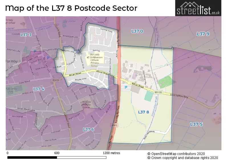
The L37 8 postcode sector stands on the Lancashire and Merseyside border.
Did you know? According to the 2021 Census, the L37 8 postcode sector is home to a bustling 1,753 residents!
Given that each sector allows for 400 unique postcode combinations. Letters C, I, K, M, O and V are not allowed in the last two letters of a postcode. With 50 postcodes already in use, this leaves 350 units available.
The L37 8 postal code covers the settlement of Formby.
The L37 8 Postcode shares a border with L37 5 (LIVERPOOL, Great Altcar), L37 9 (Formby, LIVERPOOL), L37 0 (Formby), L37 4 (Formby, LIVERPOOL), L37 6 (Formby) and L37 3 (Formby).
The sector is within the post town of LIVERPOOL.
L37 8 is a postcode sector within the L37 postcode district which is within the L Liverpool postcode area.
The Royal Mail delivery office for the L37 8 postal sector is the Formby Delivery Office.
The area of the L37 8 postcode sector is 0.48 square miles which is 1.23 square kilometres or 304.05 square acres.

Map of the L37 8 Postcode Sector
Explore the L37 8 postcode sector by using our free interactive map.
| L | 3 | 7 | - | 8 | X | X |
| L | 3 | 7 | Space | 8 | Letter | Letter |
Official List of Streets
Formby (32 Streets)
Unofficial Streets or Alternative Spellings
Schools and Places of Education Within the L37 8 Postcode Sector
Our Lady of Compassion Catholic Primary School
Voluntary aided school
Bull Cop, Liverpool, Merseyside, L37 8BZ
Head: Mr Anthony Houghton
Ofsted Rating: Good
Inspection: 2019-11-06 (1670 days ago)
Website: Visit Our Lady of Compassion Catholic Primary School Website
Phone: 01704877281
Number of Pupils: 228
House Prices in the L37 8 Postcode Sector
| Type of Property | 2018 Average | 2018 Sales | 2017 Average | 2017 Sales | 2016 Average | 2016 Sales | 2015 Average | 2015 Sales |
|---|---|---|---|---|---|---|---|---|
| Detached | £281,000 | 3 | £277,650 | 6 | £299,988 | 4 | £270,475 | 4 |
| Semi-Detached | £218,286 | 21 | £205,315 | 26 | £182,571 | 21 | £179,786 | 14 |
| Terraced | £225,000 | 1 | £0 | 0 | £190,000 | 1 | £174,983 | 3 |
| Flats | £103,500 | 6 | £86,583 | 6 | £212,250 | 6 | £177,279 | 14 |
Important Postcodes L37 8 in the Postcode Sector
L37 8BZ is the postcode for INFANTS, Our Lady of Compassion RC Primary School, Bull Cop, JUNIORS, Our Lady of Compassion RC Primary School, Bull Cop, and Our Lady of Compassion RC Primary School, Bull Cop
| The L37 8 Sector is within these Local Authorities |
|
|---|---|
| The L37 8 Sector is within these Counties |
|
| The L37 8 Sector is within these Water Company Areas |
|