The LA5 postcode district is a postal district located in the LA Lancaster postcode area with a population of 16,243 residents according to the 2021 England and Wales Census.
The area of the LA5 postcode district is 20.96 square miles which is 54.28 square kilometres or 13,412.23 acres.
Currently, the LA5 district has about 584 postcode units spread across 3 geographic postcode sectors.
Given that each sector allows for 400 unique postcode combinations, the district has a capacity of 1,200 postcodes. With 584 postcodes already in use, this leaves 616 units available.
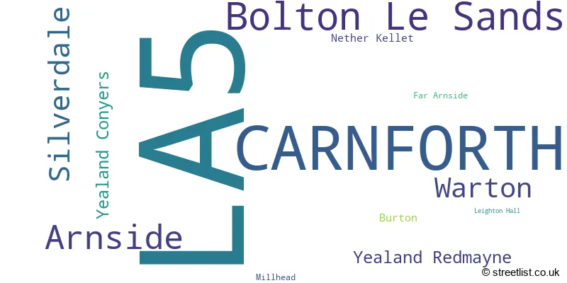
The largest settlement in the LA5 postal code is CARNFORTH followed by Bolton Le Sands, and Arnside.
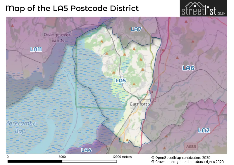
The postcode area has a boundary with Morecambe Bay.
The LA5 Postcode shares a border with LA6 (Ingleton, Kirkby Lonsdale, Holme), LA2 (Bentham, Ellel, Halton) and LA7 (MILNTHORPE, Storth, Heversham).
In the LA5 postcode district, the primary settlement is Carnforth, located in the county of Lancashire, England. Other significant settlements in this district include Bolton Le Sands, Burton, Leighton Hall, Millhead, Warton, Yealand Conyers, and Yealand Redmayne. The post town associated with the highest number of postcodes in this district is Carnforth.
For the district LA5, we have data on 4 postcode sectors. Here's a breakdown: The sector LA5 0, covers Arnside in Cumbria. The sector LA5 0, covers Silverdale in Lancashire. The sector LA5 5 is non-geographic. It's often designated for PO Boxes, large organisations, or special services. The sector LA5 8, covers Bolton Le Sands in Lancashire. The sector LA5 9, covers Carnforth and Warton in Lancashire.

Map of the LA5 Postcode District
Explore the LA5 postcode district by using our free interactive map.
When it comes to local government, postal geography often disregards political borders. However, for a breakdown in the LA5 District: the district mostly encompasses the Lancaster District (B) (487 postcodes), and finally, the Westmorland and Furness area (102 postcodes).
Recent House Sales in LA5
| Date | Price | Address |
|---|---|---|
| 29/09/2023 | £510,000 | Swallow Close, Bolton Le Sands, Carnforth, LA5 8BN |
| 28/09/2023 | £270,000 | The Nook, Bolton Le Sands, Carnforth, LA5 8DR |
| 26/09/2023 | £295,000 | Lindeth Close, Silverdale, Carnforth, LA5 0TU |
| 25/09/2023 | £295,000 | Greenwood Crescent, Bolton Le Sands, Carnforth, LA5 8BA |
| 22/09/2023 | £260,000 | Mill Lane, Bolton Le Sands, Carnforth, LA5 8EZ |
| 22/09/2023 | £170,000 | Cross Hill Court, Bolton Le Sands, Carnforth, LA5 8EG |
| 20/09/2023 | £395,000 | Swinnate Road, Arnside, Carnforth, LA5 0HR |
| 18/09/2023 | £495,000 | Sandside Road, Arnside, Carnforth, LA5 0HQ |
| 18/09/2023 | £492,500 | High Knott Road, Arnside, Carnforth, LA5 0AW |
| 15/09/2023 | £155,000 | Rupert Street, Carnforth, LA5 9UU |
Weather Forecast for LA5
Press Button to Show Forecast for Carnforth
| Time Period | Icon | Description | Temperature | Rain Probability | Wind |
|---|---|---|---|---|---|
| 06:00 to 09:00 | Sunny day | 2.0°C (feels like 1.0°C) | 1.00% | ENE 4 mph | |
| 09:00 to 12:00 | Cloudy | 7.0°C (feels like 6.0°C) | 5.00% | NE 4 mph | |
| 12:00 to 15:00 | Overcast | 9.0°C (feels like 8.0°C) | 11.00% | NE 4 mph | |
| 15:00 to 18:00 | Overcast | 9.0°C (feels like 8.0°C) | 11.00% | N 4 mph | |
| 18:00 to 21:00 | Cloudy | 8.0°C (feels like 7.0°C) | 8.00% | NNE 4 mph | |
| 21:00 to 00:00 | Partly cloudy (night) | 5.0°C (feels like 3.0°C) | 2.00% | ENE 4 mph |
Press Button to Show Forecast for Carnforth
| Time Period | Icon | Description | Temperature | Rain Probability | Wind |
|---|---|---|---|---|---|
| 00:00 to 03:00 | Partly cloudy (night) | 4.0°C (feels like 1.0°C) | 2.00% | E 4 mph | |
| 03:00 to 06:00 | Partly cloudy (night) | 2.0°C (feels like 0.0°C) | 3.00% | E 4 mph | |
| 06:00 to 09:00 | Partly cloudy (day) | 4.0°C (feels like 2.0°C) | 3.00% | E 4 mph | |
| 09:00 to 12:00 | Partly cloudy (day) | 8.0°C (feels like 6.0°C) | 6.00% | E 7 mph | |
| 12:00 to 15:00 | Cloudy | 10.0°C (feels like 8.0°C) | 9.00% | E 7 mph | |
| 15:00 to 18:00 | Cloudy | 10.0°C (feels like 9.0°C) | 14.00% | E 7 mph | |
| 18:00 to 21:00 | Cloudy | 9.0°C (feels like 7.0°C) | 11.00% | E 9 mph | |
| 21:00 to 00:00 | Partly cloudy (night) | 6.0°C (feels like 4.0°C) | 9.00% | ENE 7 mph |
Press Button to Show Forecast for Carnforth
| Time Period | Icon | Description | Temperature | Rain Probability | Wind |
|---|---|---|---|---|---|
| 00:00 to 03:00 | Cloudy | 5.0°C (feels like 2.0°C) | 13.00% | NE 7 mph | |
| 03:00 to 06:00 | Cloudy | 5.0°C (feels like 2.0°C) | 11.00% | NNE 9 mph | |
| 06:00 to 09:00 | Cloudy | 6.0°C (feels like 3.0°C) | 15.00% | NNE 9 mph | |
| 09:00 to 12:00 | Cloudy | 8.0°C (feels like 5.0°C) | 20.00% | NE 9 mph | |
| 12:00 to 15:00 | Light rain | 9.0°C (feels like 7.0°C) | 46.00% | NNE 11 mph | |
| 15:00 to 18:00 | Heavy rain shower (day) | 10.0°C (feels like 8.0°C) | 57.00% | N 9 mph | |
| 18:00 to 21:00 | Light rain shower (day) | 10.0°C (feels like 8.0°C) | 39.00% | NNW 9 mph | |
| 21:00 to 00:00 | Partly cloudy (night) | 8.0°C (feels like 5.0°C) | 10.00% | WNW 9 mph |
Where is the LA5 Postcode District?
The postcode district for LA5 is located in Carnforth. Carnforth is situated in the northwestern part of England. Nearby towns include Milnthorpe to the north (5.10 miles away), Grange-over-Sands to the northwest (5.59 miles away), Morecambe to the southwest (7.18 miles away), Lancaster to the south (8.08 miles away), Ulverston to the west (11.76 miles away), and Sedbergh to the northeast (15.94 miles away). Additionally, Carnforth is approximately 214.12 miles away from the center of London.
The district is within the post town of CARNFORTH.
The sector has postcodes within the nation of England.
The LA5 Postcode District is covers the following regions.
- East Cumbria - Cumbria - North West (England)
- Lancaster and Wyre - Lancashire - North West (England)
| Postcode Sector | Delivery Office |
|---|---|
| LA5 0 | Carnforth Delivery Office |
| LA5 8 | Carnforth Delivery Office |
| LA5 9 | Carnforth Delivery Office |
| L | A | 5 | - | X | X | X |
| L | A | 5 | Space | Numeric | Letter | Letter |
Tourist Attractions within the Postcode Area
We found 2 visitor attractions within the LA5 postcode area
| Leighton Hall |
|---|
| Historic Properties |
| Historic House / House and Garden / Palace |
| View Leighton Hall on Google Maps |
| Carnforth Station Heritage Centre |
| Visitor Centres |
| Heritage / Visitor Centre |
| View Carnforth Station Heritage Centre on Google Maps |
Current Monthly Rental Prices
| # Bedrooms | Min Price | Max Price | Avg Price |
|---|---|---|---|
| £589 | £589 | £589 | |
| 1 | £800 | £800 | £800 |
| 2 | £900 | £900 | £900 |
| 3 | £830 | £2,000 | £1,360 |
| 4 | £1,450 | £1,450 | £1,450 |
Current House Prices
| # Bedrooms | Min Price | Max Price | Avg Price |
|---|---|---|---|
| £130,000 | £400,000 | £268,333 | |
| 1 | £100,000 | £204,999 | £157,772 |
| 2 | £31,000 | £600,000 | £260,144 |
| 3 | £155,000 | £595,000 | £301,187 |
| 4 | £200,000 | £995,000 | £467,978 |
| 5 | £365,000 | £2,450,000 | £961,667 |
| 6 | £695,000 | £950,000 | £798,333 |
| 7 | £1,000,000 | £1,000,000 | £1,000,000 |
Estate Agents who Operate in the LA5 District
| Logo | Name | Brand Name | Address | Contact Number | Total Properties |
|---|---|---|---|---|---|
 | covering Carnforth | Farrell Heyworth | 18 New Street Lancaster LA1 1EG | 01524 967490 | 29 |
 | Carnforth | Hackney & Leigh | Market Street, Carnforth, LA5 9BT | 01524 235887 | 26 |
 | Milnthorpe | Waterhouse Estate Agents | 10 Park Road Milnthorpe LA7 7AD | 01524 967559 | 15 |
 | Arnside | Hackney & Leigh | The Promenade, Arnside, Cumbria, LA5 0HF | 01524 967486 | 11 |
 | Lancaster | Houseclub | 746 Cameron House, White Cross, Lancaster, LA1 4XQ | 01524 969718 | 10 |
| Type of Property | 2018 Average | 2018 Sales | 2017 Average | 2017 Sales | 2016 Average | 2016 Sales | 2015 Average | 2015 Sales |
|---|---|---|---|---|---|---|---|---|
| Detached | £307,550 | 103 | £292,135 | 117 | £312,649 | 130 | £308,454 | 119 |
| Semi-Detached | £200,174 | 92 | £200,782 | 105 | £208,450 | 114 | £181,989 | 83 |
| Terraced | £140,819 | 75 | £148,323 | 87 | £147,798 | 62 | £145,526 | 75 |
| Flats | £187,405 | 76 | £197,135 | 17 | £154,574 | 27 | £224,026 | 19 |