The LL54 6 postcode sector is within the county of Gwynedd.
Did you know? According to the 2021 Census, the LL54 6 postcode sector is home to a bustling 4,195 residents!
Given that each sector allows for 400 unique postcode combinations. Letters C, I, K, M, O and V are not allowed in the last two letters of a postcode. With 157 postcodes already in use, this leaves 243 units available.
The largest settlement in the LL54 6 postal code is PENYGROES followed by TALYSARN, and LLANLLYFNI.
The LL54 6 Postcode shares a border with LL54 5 (TREFOR, LLANDWROG, CLYNNOG FAWR), LL55 4 (LLANBERIS, LLANRUG, WAUNFAWR), LL51 9 (GARNDOLBENMAEN, GOLAN, CWM PENNANT) and LL54 7 (Y GROESLON, RHOSGADFAN, RHOSTRYFAN).
The sector is within the post town of CAERNARFON.
LL54 6 is a postcode sector within the LL54 postcode district which is within the LL Llandudno postcode area.
The Royal Mail delivery office for the LL54 6 postal sector is the Caernarfon Delivery Office.
The area of the LL54 6 postcode sector is 25.93 square miles which is 67.15 square kilometres or 16,592.74 square acres.

Map of the LL54 6 Postcode Sector
Explore the LL54 6 postcode sector by using our free interactive map.
| L | L | 5 | 4 | - | 6 | X | X |
| L | L | 5 | 4 | Space | 6 | Letter | Letter |
Official List of Streets
Penygroes (38 Streets)
Nantlle (5 Streets)
Talysarn (23 Streets)
Llanllyfni (5 Streets)
Rhyd Ddu (2 Streets)
Unofficial Streets or Alternative Spellings
Penygroes
HEN L�N L�N PITAR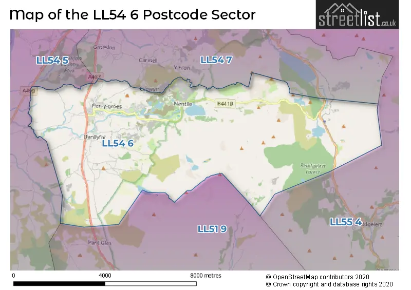
House Prices in the LL54 6 Postcode Sector
| Type of Property | 2018 Average | 2018 Sales | 2017 Average | 2017 Sales | 2016 Average | 2016 Sales | 2015 Average | 2015 Sales |
|---|---|---|---|---|---|---|---|---|
| Detached | £230,282 | 14 | £229,783 | 12 | £166,875 | 4 | £170,300 | 10 |
| Semi-Detached | £150,733 | 6 | £123,889 | 9 | £108,000 | 10 | £99,733 | 9 |
| Terraced | £94,516 | 49 | £87,278 | 38 | £81,955 | 33 | £79,583 | 33 |
| Flats | £0 | 0 | £0 | 0 | £100,000 | 1 | £122,000 | 1 |
Important Postcodes LL54 6 in the Postcode Sector
LL54 6AA is the postcode for Ysgol Dyffryn Nantlle, Ffordd y Brenin, CANTEEN BLOCK, Ysgol Dyffryn Nantlle, Ffordd y Brenin, MUSIC & 6TH FORM BLOCK, Ysgol Dyffryn Nantlle, Ffordd y Brenin, BLOCK CANOL, Ysgol Dyffryn Nantlle, Ffordd y Brenin, and BLOCK UCHAF, Ysgol Dyffryn Nantlle, Ffordd y Brenin
LL54 6EE is the postcode for Nebo Primary School, Nebo
LL54 6HD is the postcode for Plas Gwilym, Victoria Road, and PLAS GWILYM, VICTORIA ROAD, PENYGROES
LL54 6HJ is the postcode for Dyffryn Nantlle Leisure Centre, Plas Silyn, County Road, Penygroes, and Dyffryn Nantlle Leisure Centre, Plas Silyn, County Road
| The LL54 6 Sector is within these Local Authorities |
|
|---|---|
| The LL54 6 Sector is within these Counties |
|
| The LL54 6 Sector is within these Water Company Areas |
|