The LS20 9 postcode sector is within the county of West Yorkshire.
Did you know? According to the 2021 Census, the LS20 9 postcode sector is home to a bustling 6,311 residents!
Given that each sector allows for 400 unique postcode combinations. Letters C, I, K, M, O and V are not allowed in the last two letters of a postcode. With 176 postcodes already in use, this leaves 224 units available.
The LS20 9 postal code covers the settlement of Guiseley.
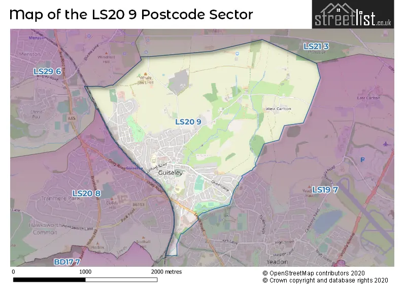
The LS20 9 Postcode shares a border with LS20 8 (Guiseley, Hawksworth), LS21 3 (OTLEY, Pool In Wharfedale), LS19 7 (Yeadon, Rawdon) and LS29 6 (Menston).
The sector is within the post town of LEEDS.
LS20 9 is a postcode sector within the LS20 postcode district which is within the LS Leeds postcode area.
The Royal Mail delivery office for the LS20 9 postal sector is the Aireborough Delivery Office.
The area of the LS20 9 postcode sector is 1.88 square miles which is 4.87 square kilometres or 1,204.24 square acres.

Map of the LS20 9 Postcode Sector
Explore the LS20 9 postcode sector by using our free interactive map.
| L | S | 2 | 0 | - | 9 | X | X |
| L | S | 2 | 0 | Space | 9 | Letter | Letter |
Official List of Streets
Guiseley (123 Streets)
Unofficial Streets or Alternative Spellings
Schools and Places of Education Within the LS20 9 Postcode Sector
Guiseley Primary School
Foundation school
Oxford Road, Leeds, West Yorkshire, LS20 9DA
Head: Mrs Fiona Wharton
Ofsted Rating: Good
Inspection: 2023-06-14 (354 days ago)
Website: Visit Guiseley Primary School Website
Phone: 01943873359
Number of Pupils: 441
St. Oswald's CofE Primary School
Voluntary aided school
The Green, Leeds, West Yorkshire, LS20 9BT
Head: Mr Jonathan Davies
Ofsted Rating: Good
Inspection: 2023-12-06 (179 days ago)
Website: Visit St. Oswald's CofE Primary School Website
Phone: 01943873570
Number of Pupils: 395
House Prices in the LS20 9 Postcode Sector
| Type of Property | 2018 Average | 2018 Sales | 2017 Average | 2017 Sales | 2016 Average | 2016 Sales | 2015 Average | 2015 Sales |
|---|---|---|---|---|---|---|---|---|
| Detached | £359,322 | 18 | £417,086 | 11 | £603,752 | 16 | £380,014 | 30 |
| Semi-Detached | £223,748 | 24 | £231,771 | 38 | £210,395 | 32 | £218,384 | 57 |
| Terraced | £220,302 | 47 | £199,228 | 45 | £210,242 | 61 | £215,664 | 70 |
| Flats | £199,214 | 7 | £170,748 | 20 | £179,188 | 17 | £149,035 | 10 |
Important Postcodes LS20 9 in the Postcode Sector
LS20 9BT is the postcode for St. Oswalds C of E Junior School, The Green, Aireborough Leisure Centre, The Green, Guiseley, Aireborough Leisure Centre, The Green, and St Oswalds C of E Primary School, The Green, Guiseley
LS20 9DA is the postcode for Guiseley Primary School, Oxford Road, Guiseley, Guiseley Primary School, Oxford Road, and Guiseley Infant School, Oxford Road, Guiseley
LS20 9LA is the postcode for TOWNGATE HOUSE, Leeds Community & Mental Health Services, Queensway
| The LS20 9 Sector is within these Local Authorities |
|
|---|---|
| The LS20 9 Sector is within these Counties |
|
| The LS20 9 Sector is within these Water Company Areas |
|