The LS26 8 postcode sector is within the county of West Yorkshire.
Did you know? According to the 2021 Census, the LS26 8 postcode sector is home to a bustling 12,727 residents!
Given that each sector allows for 400 unique postcode combinations. Letters C, I, K, M, O and V are not allowed in the last two letters of a postcode. With 330 postcodes already in use, this leaves 70 units available.
The largest settlement in the LS26 8 postal code is Woodlesford followed by Oulton, and Swillington.
The LS26 8 Postcode shares a border with WF3 3 (Lofthouse, Robin Hood, Thorpe), WF3 4 (Stanley, WAKEFIELD), LS15 0 (LEEDS), LS25 2 (Garforth), LS25 7 (Kippax, LEEDS), LS26 0 (Rothwell), WF10 2 (Allerton Bywater, CASTLEFORD, Ledston), LS25 1 (Garforth), LS15 4 (Barwick In Elmet, Scholes, LEEDS), LS15 9 (LEEDS, Colton) and LS26 9 (Methley, Mickletown Methley).
The sector is within the post town of LEEDS.
LS26 8 is a postcode sector within the LS26 postcode district which is within the LS Leeds postcode area.
The Royal Mail delivery office for the LS26 8 postal sector is the Garforth Delivery Office.
The area of the LS26 8 postcode sector is 8.60 square miles which is 22.28 square kilometres or 5,505.64 square acres.
The LS26 8 postcode sector is crossed by the M62 motorway.
The LS26 8 postcode sector is crossed by the M1 motorway.
The LS26 8 postcode sector is crossed by the A63 Major A road.

Map of the LS26 8 Postcode Sector
Explore the LS26 8 postcode sector by using our free interactive map.
| L | S | 2 | 6 | - | 8 | X | X |
| L | S | 2 | 6 | Space | 8 | Letter | Letter |
Official List of Streets
Oulton (67 Streets)
Woodlesford (85 Streets)
Great Preston (28 Streets)
Swillington (44 Streets)
Unofficial Streets or Alternative Spellings
Oulton
CASTLE GATEAllerton Bywater
BRIGSHAW LANE LEEDS ROAD PRESTON LANERothwell
BULLOUGH LANE OULTON LANE ROYDS LANE SEVENTH AVENUE SIXTH AVENUEMethley
LEEDS ROAD METHLEY LANEKippax
BRECKS LANE STATION ROADGarforth
WAKEFIELD ROADLEEDS
PONTEFRACT LANE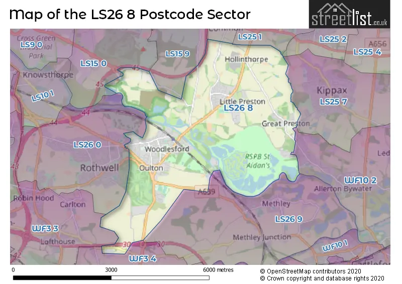
House Prices in the LS26 8 Postcode Sector
| Type of Property | 2018 Average | 2018 Sales | 2017 Average | 2017 Sales | 2016 Average | 2016 Sales | 2015 Average | 2015 Sales |
|---|---|---|---|---|---|---|---|---|
| Detached | £323,723 | 54 | £329,410 | 100 | £342,804 | 98 | £319,001 | 79 |
| Semi-Detached | £179,410 | 84 | £175,513 | 88 | £157,822 | 107 | £154,449 | 83 |
| Terraced | £161,363 | 51 | £144,910 | 48 | £158,535 | 62 | £157,106 | 37 |
| Flats | £107,214 | 7 | £111,999 | 5 | £112,332 | 9 | £116,792 | 6 |
Important Postcodes LS26 8 in the Postcode Sector
LS26 8AR is the postcode for GREAT PRESTON C OF E PRIMARY SCHOOL, PRESTON LANE, GREAT PRESTON, Great Preston C of E Primary School, Preston Lane, and Great Preston Church Of England Primary School, Preston Lane, Great Preston
LS26 8AS is the postcode for Great & Little Preston C of E Infant School, Preston Lane
LS26 8DX is the postcode for SWILLINGTON PRIMARY SCHOOL, CHURCH LANE, SWILLINGTON, and Swillington Primary School, Church Lane
LS26 8EL is the postcode for Rothwell Sports Centre, Wakefield Road, and Rothwell Leisure Centre, Wakefield Road, Oulton
LS26 8EX is the postcode for WEST BUILDING, Royds School, Pennington Lane, NORTH BUILDING, Royds School, Pennington Lane, MAIN BUILDING, Oulton Academy, Pennington Lane, EAST BUILDING, Royds School, Pennington Lane, Royds School, Pennington Lane, WEST BUILDING, Oulton Academy, Pennington Lane, MAIN BUILDING, Royds School, Pennington Lane, EAST BUILDING, Oulton Academy, Pennington Lane, and NORTH BUILDING, Oulton Academy, Pennington Lane
LS26 8HE is the postcode for MAIN BUILDING, Vehicle Testing Centre, Patrick Green, and Vehicle Testing Centre, Patrick Green
LS26 8NT is the postcode for Oulton Primary School, Green Lea, and Oulton Primary School, Green Lea, Oulton
LS26 8RD is the postcode for WOODLESFORD PRIMARY SCHOOL, CHURCH STREET, WOODLESFORD, and Woodlesford Primary School, Church Street
LS26 8RY is the postcode for Rothwell Adult Training Centre Leeds, Holmsley Lane
LS26 8SZ is the postcode for Oulton Medical Centre, Quarry Hill
| The LS26 8 Sector is within these Local Authorities |
|
|---|---|
| The LS26 8 Sector is within these Counties |
|
| The LS26 8 Sector is within these Water Company Areas |
|