The LS26 postcode district is a postal district located in the LS Leeds postcode area with a population of 31,354 residents according to the 2021 England and Wales Census.
The area of the LS26 postcode district is 16.85 square miles which is 43.64 square kilometres or 10,783.90 acres.
Currently, the LS26 district has about 794 postcode units spread across 3 geographic postcode sectors.
Given that each sector allows for 400 unique postcode combinations, the district has a capacity of 1,200 postcodes. With 794 postcodes already in use, this leaves 406 units available.
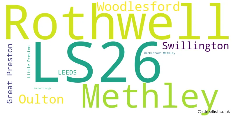
The largest settlement in the LS26 postal code is Rothwell followed by Woodlesford, and Methley.
The LS26 Postcode shares a border with LS10 (LEEDS, Hunslet, Middleton), WF10 (CASTLEFORD, Allerton Bywater, Ledston), WF3 (Tingley, Stanley, East Ardsley), WF6 (NORMANTON, Normanton Industrial Estate, Altofts) and LS15 (LEEDS, Barwick In Elmet, Scholes).
In the LS26 postcode district in West Yorkshire, the primary settlement is Rothwell, located in the county of West Yorkshire, England. Other significant settlements in this postcode district include Great Preston, Little Preston, Oulton, Swillington, Woodlesford, Methley, and Mickletown Methley. The most significant post town in this district is Leeds.
For the district LS26, we have data on 4 postcode sectors. Here's a breakdown: The sector LS26 0, covers Rothwell in West Yorkshire. The sector LS26 1 is non-geographic. It's often designated for PO Boxes, large organisations, or special services. The sector LS26 8, covers Woodlesford and Oulton and Swillington and Great Preston in West Yorkshire. The sector LS26 9, covers Methley in West Yorkshire.

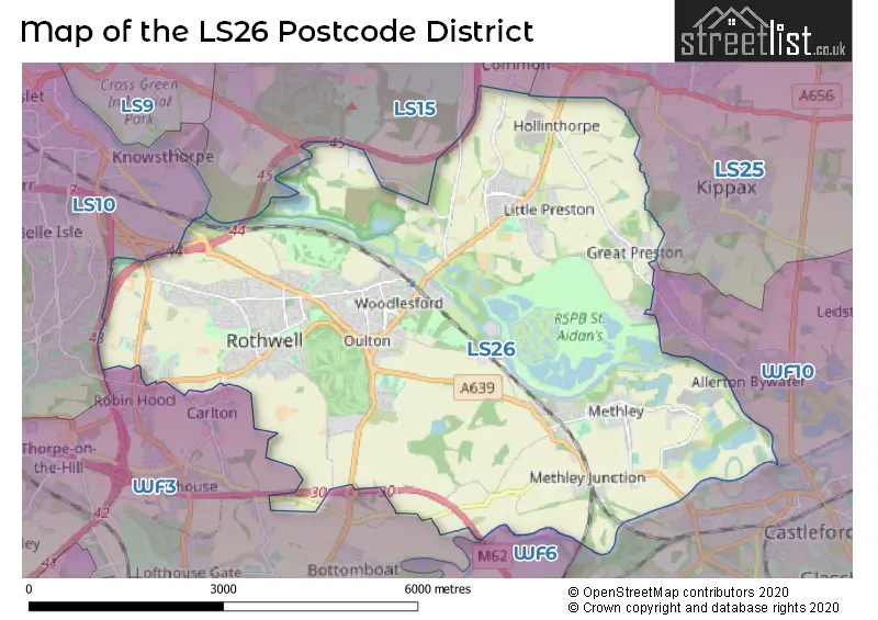
Map of the LS26 Postcode District
Explore the LS26 postcode district by using our free interactive map.
When it comes to local government, postal geography often disregards political borders. However, for a breakdown in the LS26 District: the district mostly encompasses the Leeds District (B) (796 postcodes), and finally, the Wakefield District (B) area (9 postcodes).
Recent House Sales in LS26
| Date | Price | Address |
|---|---|---|
| 29/09/2023 | £205,000 | Pinders Green Drive, Methley, Leeds, LS26 9BA |
| 27/09/2023 | £175,000 | Manor Road, Rothwell, Leeds, LS26 0RD |
| 27/09/2023 | £520,000 | Sherwood Way, Woodlesford, Leeds, LS26 8GN |
| 15/09/2023 | £180,000 | Lynwood Crescent, Woodlesford, Leeds, LS26 8LJ |
| 11/09/2023 | £165,000 | Knavesmire, Rothwell, Leeds, LS26 0GW |
| 08/09/2023 | £385,000 | Lime Tree Close, Woodlesford, Leeds, LS26 8WS |
| 06/09/2023 | £135,000 | Spibey Lane, Rothwell, Leeds, LS26 0NW |
| 01/09/2023 | £235,000 | Welles Avenue, Methley, Leeds, LS26 9FB |
| 31/08/2023 | £250,000 | Albert Court, Great Preston, Leeds, LS26 8GF |
| 30/08/2023 | £218,000 | Langdale Road, Woodlesford, Leeds, LS26 8XG |
Where is the LS26 Postcode District?
The postcode district LS26 is located in Leeds. It is close to the towns of Normanton, Castleford, Wakefield, Knottingley, and Batley. Additionally, it is approximately 164.5 miles away from the center of London.
The district is within the post town of LEEDS.
The sector has postcodes within the nation of England.
The LS26 Postcode District is covers the following regions.
- Leeds - West Yorkshire - Yorkshire and The Humber
- Wakefield - West Yorkshire - Yorkshire and The Humber
Weather Forecast for LS26
Press Button to Show Forecast for Rothwell (West Yorkshire)
| Time Period | Icon | Description | Temperature | Rain Probability | Wind |
|---|---|---|---|---|---|
| 21:00 to 00:00 | Cloudy | 12.0°C (feels like 11.0°C) | 4.00% | N 9 mph |
Press Button to Show Forecast for Rothwell (West Yorkshire)
| Time Period | Icon | Description | Temperature | Rain Probability | Wind |
|---|---|---|---|---|---|
| 00:00 to 03:00 | Overcast | 10.0°C (feels like 7.0°C) | 9.00% | N 11 mph | |
| 03:00 to 06:00 | Overcast | 9.0°C (feels like 6.0°C) | 10.00% | N 11 mph | |
| 06:00 to 09:00 | Overcast | 10.0°C (feels like 8.0°C) | 9.00% | N 11 mph | |
| 09:00 to 12:00 | Overcast | 13.0°C (feels like 11.0°C) | 9.00% | NNE 11 mph | |
| 12:00 to 15:00 | Partly cloudy (day) | 17.0°C (feels like 14.0°C) | 1.00% | NE 13 mph | |
| 15:00 to 18:00 | Cloudy | 17.0°C (feels like 14.0°C) | 4.00% | NE 13 mph | |
| 18:00 to 21:00 | Overcast | 14.0°C (feels like 11.0°C) | 8.00% | NE 11 mph | |
| 21:00 to 00:00 | Overcast | 11.0°C (feels like 9.0°C) | 9.00% | NNE 11 mph |
Press Button to Show Forecast for Rothwell (West Yorkshire)
| Time Period | Icon | Description | Temperature | Rain Probability | Wind |
|---|---|---|---|---|---|
| 00:00 to 03:00 | Overcast | 10.0°C (feels like 8.0°C) | 9.00% | N 9 mph | |
| 03:00 to 06:00 | Cloudy | 10.0°C (feels like 8.0°C) | 9.00% | N 9 mph | |
| 06:00 to 09:00 | Overcast | 10.0°C (feels like 9.0°C) | 13.00% | NNW 9 mph | |
| 09:00 to 12:00 | Light rain | 13.0°C (feels like 11.0°C) | 55.00% | N 9 mph | |
| 12:00 to 15:00 | Heavy rain shower (day) | 14.0°C (feels like 13.0°C) | 66.00% | N 9 mph | |
| 15:00 to 18:00 | Light rain shower (day) | 15.0°C (feels like 14.0°C) | 38.00% | NNW 7 mph | |
| 18:00 to 21:00 | Light rain shower (day) | 14.0°C (feels like 12.0°C) | 44.00% | NNW 9 mph | |
| 21:00 to 00:00 | Light rain | 11.0°C (feels like 10.0°C) | 51.00% | NW 7 mph |
Press Button to Show Forecast for Rothwell (West Yorkshire)
| Time Period | Icon | Description | Temperature | Rain Probability | Wind |
|---|---|---|---|---|---|
| 00:00 to 03:00 | Overcast | 11.0°C (feels like 10.0°C) | 18.00% | WNW 4 mph | |
| 03:00 to 06:00 | Cloudy | 10.0°C (feels like 10.0°C) | 15.00% | WSW 4 mph | |
| 06:00 to 09:00 | Overcast | 11.0°C (feels like 10.0°C) | 14.00% | SW 7 mph | |
| 09:00 to 12:00 | Overcast | 13.0°C (feels like 12.0°C) | 12.00% | SW 9 mph | |
| 12:00 to 15:00 | Cloudy | 15.0°C (feels like 14.0°C) | 8.00% | SW 9 mph | |
| 15:00 to 18:00 | Cloudy | 16.0°C (feels like 15.0°C) | 10.00% | SW 9 mph | |
| 18:00 to 21:00 | Cloudy | 15.0°C (feels like 14.0°C) | 10.00% | SW 7 mph | |
| 21:00 to 00:00 | Cloudy | 12.0°C (feels like 12.0°C) | 10.00% | SW 4 mph |
Press Button to Show Forecast for Rothwell (West Yorkshire)
| Time Period | Icon | Description | Temperature | Rain Probability | Wind |
|---|---|---|---|---|---|
| 00:00 to 03:00 | Partly cloudy (night) | 11.0°C (feels like 11.0°C) | 7.00% | S 4 mph | |
| 03:00 to 06:00 | Cloudy | 10.0°C (feels like 9.0°C) | 10.00% | ESE 4 mph | |
| 06:00 to 09:00 | Cloudy | 10.0°C (feels like 10.0°C) | 10.00% | SE 4 mph | |
| 09:00 to 12:00 | Cloudy | 13.0°C (feels like 11.0°C) | 12.00% | SSE 7 mph | |
| 12:00 to 15:00 | Cloudy | 15.0°C (feels like 14.0°C) | 16.00% | SSE 4 mph | |
| 15:00 to 18:00 | Cloudy | 15.0°C (feels like 14.0°C) | 18.00% | SSE 9 mph | |
| 18:00 to 21:00 | Cloudy | 15.0°C (feels like 13.0°C) | 15.00% | SE 7 mph | |
| 21:00 to 00:00 | Cloudy | 12.0°C (feels like 11.0°C) | 8.00% | ESE 7 mph |
| Postcode Sector | Delivery Office |
|---|---|
| LS26 0 | Garforth Delivery Office |
| LS26 8 | Garforth Delivery Office |
| LS26 9 | Garforth Delivery Office |
| L | S | 2 | 6 | - | X | X | X |
| L | S | 2 | 6 | Space | Numeric | Letter | Letter |
Current Monthly Rental Prices
| # Bedrooms | Min Price | Max Price | Avg Price |
|---|---|---|---|
| 2 | £650 | £1,150 | £841 |
| 3 | £875 | £1,600 | £1,206 |
| 4 | £995 | £995 | £995 |
Current House Prices
| # Bedrooms | Min Price | Max Price | Avg Price |
|---|---|---|---|
| £45,000 | £300,000 | £172,500 | |
| 1 | £148,000 | £220,000 | £184,000 |
| 2 | £98,000 | £299,995 | £209,412 |
| 3 | £149,950 | £625,000 | £281,069 |
| 4 | £245,000 | £1,499,000 | £459,305 |
| 5 | £280,000 | £1,500,000 | £645,415 |
| 7 | £799,950 | £799,950 | £799,950 |
Estate Agents who Operate in the LS26 District
| Logo | Name | Brand Name | Address | Contact Number | Total Properties |
|---|---|---|---|---|---|
 | Rothwell | Manning Stainton | 30 Marsh Street, Rothwell, Leeds, LS26 0BB | 0113 519 1794 | 64 |
 | Rothwell | Reeds Rains | 50-52 Commercial Street Rothwell LS26 0QB | 0113 487 2376 | 22 |
 | Rothwell | Emsleys Estate Agents | 65 Commercial Street, Rothwell, Leeds, LS26 0QD | 0113 519 1210 | 17 |
 | covering Leeds | Purplebricks | Suite 7 First Floor Cranmore Drive Shirley Solihull B90 4RZ | 0113 519 9101 | 12 |
 | Yorkshire | Strike | Nationwide | 0113 519 9126 | 6 |
| Type of Property | 2018 Average | 2018 Sales | 2017 Average | 2017 Sales | 2016 Average | 2016 Sales | 2015 Average | 2015 Sales |
|---|---|---|---|---|---|---|---|---|
| Detached | £321,675 | 136 | £313,870 | 234 | £319,580 | 188 | £303,933 | 131 |
| Semi-Detached | £183,534 | 248 | £174,639 | 251 | £157,091 | 237 | £152,274 | 212 |
| Terraced | £159,010 | 156 | £148,663 | 157 | £151,963 | 181 | £136,196 | 127 |
| Flats | £106,350 | 10 | £116,305 | 18 | £110,925 | 20 | £118,155 | 11 |