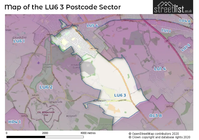
The LU6 3 postcode sector stands on the Bedfordshire and Hertfordshire border.
Did you know? According to the 2021 Census, the LU6 3 postcode sector is home to a bustling 12,304 residents!
Given that each sector allows for 400 unique postcode combinations. Letters C, I, K, M, O and V are not allowed in the last two letters of a postcode. With 207 postcodes already in use, this leaves 193 units available.
The largest settlements in the LU6 3 postal code are DUNSTABLE and Kensworth.
The LU6 3 Postcode shares a border with AL3 8 (Markyate, Flamstead), LU1 4 (Caddington, Slip End, Woodside), LU6 1 (DUNSTABLE, Totternhoe), LU6 2 (Eaton Bray, Edlesborough, DUNSTABLE) and LU5 4 (DUNSTABLE, Woodside Estate).
The sector is within the post town of DUNSTABLE.
LU6 3 is a postcode sector within the LU6 postcode district which is within the LU Luton postcode area.
The Royal Mail delivery office for the LU6 3 postal sector is the Dunstable Delivery Office.
The area of the LU6 3 postcode sector is 3.75 square miles which is 9.72 square kilometres or 2,401.06 square acres.
The LU6 3 postcode sector is crossed by the A5 Major A road.

Map of the LU6 3 Postcode Sector
Explore the LU6 3 postcode sector by using our free interactive map.
| L | U | 6 | - | 3 | X | X |
| L | U | 6 | Space | 3 | Letter | Letter |
Official List of Streets
DUNSTABLE (107 Streets)
Kensworth (17 Streets)
Unofficial Streets or Alternative Spellings
Kensworth
WHIPSNADE ROADCaddington
DUNSTABLE ROAD MILLFIELD LANEDUNSTABLE
ALBION STREET BOROUGH ROAD BRITAIN STREET CHURCH STREET CLIFTON ROAD GREAT NORTHERN ROAD HIGH STREET NORTH KING STREET MAYFIELD ROAD ROYCE CLOSE SOUTHWOOD ROAD UNION STREET WALNUT GROVE WEST PARADE WEST STREETMarkyate
BUCKWOOD ROAD DUNSTABLE ROADSchools and Places of Education Within the LU6 3 Postcode Sector
Ardley Hill Academy
Academy converter
Lowther Road, Dunstable, Bedfordshire, LU6 3NZ
Head: Headteacher Stephen Fox
Ofsted Rating: Requires improvement
Inspection: 2022-02-23 (820 days ago)
Website: Visit Ardley Hill Academy Website
Phone: 01582667955
Number of Pupils: 454
Dunstable Icknield Lower School
Community school
Burr Street, Dunstable, Bedfordshire, LU6 3AG
Head: Mrs Glynn Stirling
Ofsted Rating: Outstanding
Inspection: 2011-05-26 (4746 days ago)
Website: Visit Dunstable Icknield Lower School Website
Phone: 01582663709
Number of Pupils: 336
Kensworth Church of England Academy
Academy sponsor led
Common Road, Dunstable, Bedfordshire, LU6 3RH
Head: Mrs Sarah Dryden
Ofsted Rating: Good
Inspection: 2022-02-02 (841 days ago)
Website: Visit Kensworth Church of England Academy Website
Phone: 01582872336
Number of Pupils: 81
Lark Rise Academy
Academy converter
Cartmel Drive, Dunstable, Bedfordshire, LU6 3PT
Head: Mrs Romina Lang
Ofsted Rating: Outstanding
Inspection: 2013-12-18 (3809 days ago)
Website: Visit Lark Rise Academy Website
Phone: 01582607852
Number of Pupils: 365
Queensbury Academy
Academy sponsor led
Langdale Road, Dunstable, Bedfordshire, LU6 3BU
Head: Ms Helen Palmer
Ofsted Rating: Good
Inspection: 2022-12-01 (539 days ago)
Website: Visit Queensbury Academy Website
Phone: 01582601241
Number of Pupils: 1238
Watling Lower School
Community school
Bull Pond Lane, Dunstable, Bedfordshire, LU6 3BJ
Head: Mr Robert Cook
Ofsted Rating: Good
Inspection: 2019-02-21 (1918 days ago)
Website: Visit Watling Lower School Website
Phone: 01582662232
Number of Pupils: 203
House Prices in the LU6 3 Postcode Sector
| Type of Property | 2018 Average | 2018 Sales | 2017 Average | 2017 Sales | 2016 Average | 2016 Sales | 2015 Average | 2015 Sales |
|---|---|---|---|---|---|---|---|---|
| Detached | £415,705 | 39 | £444,131 | 42 | £439,500 | 44 | £379,961 | 51 |
| Semi-Detached | £345,972 | 71 | £341,499 | 66 | £301,243 | 67 | £271,851 | 71 |
| Terraced | £272,129 | 58 | £257,591 | 73 | £234,462 | 82 | £206,890 | 70 |
| Flats | £152,194 | 51 | £144,505 | 47 | £120,280 | 81 | £116,270 | 57 |
Important Postcodes LU6 3 in the Postcode Sector
LU6 3AG is the postcode for Dunstable Icknield Lower School, Burr Street
LU6 3BJ is the postcode for Watling Lower School, Bullpond Lane, and WATLING LOWER SCHOOL, BULLPOND LANE, DUNSTABLE
LU6 3BU is the postcode for EAST BUILDING, Queensbury Academy, Langdale Road, CENTRAL BUILDING, Queensbury Academy, Langdale Road, EAST BUILDING, Queensbury School, Langdale Road, WEST BUILDING, Queensbury Academy, Langdale Road, WEST BUILDING, Queensbury School, Langdale Road, and CENTRAL BUILDING, Queensbury School, Langdale Road
LU6 3JA is the postcode for Queensborough House, Friars Walk
LU6 3JH is the postcode for The Surgery, 58 Kirby Road
LU6 3LY is the postcode for THE CHILTERN SCHOOL, BEECH ROAD, DUNSTABLE, New Build, Chiltern Primary School, and Chiltern Primary School, Beech Road
LU6 3NZ is the postcode for Ardley Hill Academy, Lowther Road
LU6 3PT is the postcode for Lark Rise Academy, Cartmel Drive
LU6 3RH is the postcode for Kensworth Primary School, Common Road
LU6 3SD is the postcode for Beech Close Resource Centre, 5 Beech Road, Beech Close
LU6 3SU is the postcode for Dunstable Health Centre, Priory Gardens
| The LU6 3 Sector is within these Local Authorities |
|
|---|---|
| The LU6 3 Sector is within these Counties |
|
| The LU6 3 Sector is within these Water Company Areas |
|