The M12 4 postcode sector is within the county of Greater Manchester.
Did you know? According to the 2021 Census, the M12 4 postcode sector is home to a bustling 7,888 residents!
Given that each sector allows for 400 unique postcode combinations. Letters C, I, K, M, O and V are not allowed in the last two letters of a postcode. With 179 postcodes already in use, this leaves 221 units available.
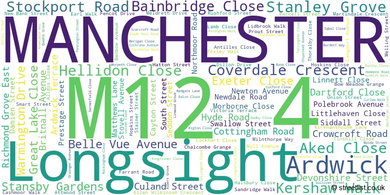
The largest settlement in the M12 4 postal code is MANCHESTER followed by Longsight, and Ardwick.
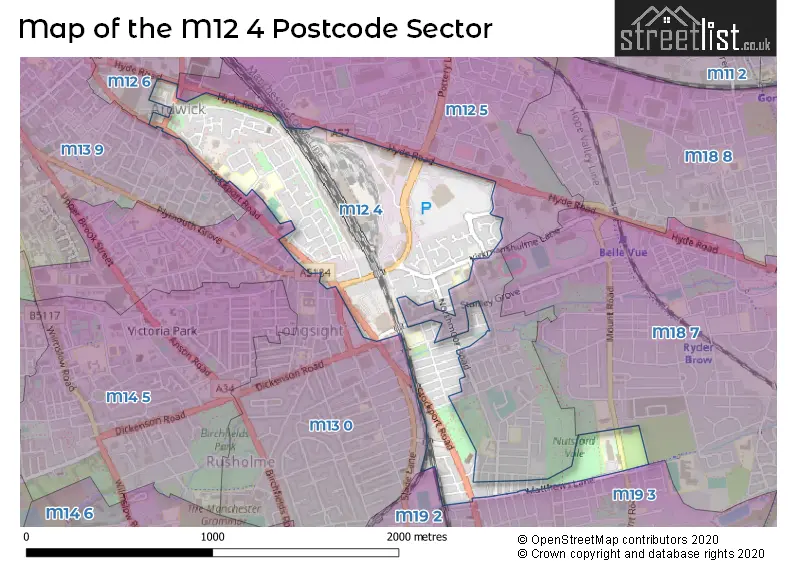
The M12 4 Postcode shares a border with M12 6 (MANCHESTER, Ardwick), M18 7 (MANCHESTER, Gorton), M12 5 (MANCHESTER, Longsight), M13 0 (MANCHESTER), M19 3 (MANCHESTER, Levenshulme), M13 9 (MANCHESTER) and M19 2 (MANCHESTER, Levenshulme, Burnage).
The sector is within the post town of MANCHESTER.
M12 4 is a postcode sector within the M12 postcode district which is within the M Manchester postcode area.
The Royal Mail delivery office for the M12 4 postal sector is the South East (m) Delivery Office.
The area of the M12 4 postcode sector is 0.59 square miles which is 1.54 square kilometres or 379.37 square acres.

Map of the M12 4 Postcode Sector
Explore the M12 4 postcode sector by using our free interactive map.
| M | 1 | 2 | - | 4 | X | X |
| M | 1 | 2 | Space | 4 | Letter | Letter |
Official List of Streets
MANCHESTER (109 Streets)
Ardwick (2 Streets)
Unofficial Streets or Alternative Spellings
Longsight
EAST ROADMANCHESTER
AGNES STREET BELGATE CLOSE BIRCH LANE BRACEWELL CLOSE BROOK AVENUE DEEPCAR STREET DEVONSHIRE STREET SOUTH LEEDALE STREET LONGDEN ROAD MITRE ROAD MOUNT ROAD NORMAN GROVE PARRY ROAD PINK BANK LANE PLYMOUTH GROVE RANDOLPH STREET RICHMOND GROVE SPRING STREET TOLL GATE CLOSE WINTERFORD AVENUE BROOK TERRACE CHELL STREET COPPING STREET CRINGLEFORD WALK DENCOMBE STREET GREY STREET HAYLEY STREET KIRKMANSHULME ROAD KNOWDALE WAY LINNET CLOSE MIDWAY STREET MORBOURNE CLOSE OLWEN AVENUE PATCHETT STREET POTTERY LANE RONA WALK SAINT JOHNS ROAD ST JOHNS ROAD ST OSWALDS ROAD TOLL BAR STREETWeather Forecast for M12 4
Press Button to Show Forecast for West Gorton
| Time Period | Icon | Description | Temperature | Rain Probability | Wind |
|---|---|---|---|---|---|
| 15:00 to 18:00 | Light rain | 13.0°C (feels like 9.0°C) | 49.00% | S 16 mph | |
| 18:00 to 21:00 | Light rain | 12.0°C (feels like 9.0°C) | 47.00% | S 16 mph | |
| 21:00 to 00:00 | Cloudy | 11.0°C (feels like 8.0°C) | 10.00% | S 13 mph |
Press Button to Show Forecast for West Gorton
| Time Period | Icon | Description | Temperature | Rain Probability | Wind |
|---|---|---|---|---|---|
| 00:00 to 03:00 | Cloudy | 10.0°C (feels like 8.0°C) | 12.00% | SSE 11 mph | |
| 03:00 to 06:00 | Cloudy | 10.0°C (feels like 7.0°C) | 5.00% | SE 11 mph | |
| 06:00 to 09:00 | Partly cloudy (day) | 9.0°C (feels like 7.0°C) | 2.00% | SE 11 mph | |
| 09:00 to 12:00 | Cloudy | 13.0°C (feels like 10.0°C) | 3.00% | SE 13 mph | |
| 12:00 to 15:00 | Partly cloudy (day) | 16.0°C (feels like 12.0°C) | 5.00% | SSE 16 mph | |
| 15:00 to 18:00 | Cloudy | 16.0°C (feels like 13.0°C) | 10.00% | SSE 13 mph | |
| 18:00 to 21:00 | Cloudy | 14.0°C (feels like 12.0°C) | 12.00% | S 11 mph | |
| 21:00 to 00:00 | Cloudy | 12.0°C (feels like 11.0°C) | 12.00% | SSE 7 mph |
Press Button to Show Forecast for West Gorton
| Time Period | Icon | Description | Temperature | Rain Probability | Wind |
|---|---|---|---|---|---|
| 00:00 to 03:00 | Light rain shower (night) | 10.0°C (feels like 9.0°C) | 32.00% | SSE 4 mph | |
| 03:00 to 06:00 | Cloudy | 9.0°C (feels like 9.0°C) | 8.00% | SE 4 mph | |
| 06:00 to 09:00 | Cloudy | 10.0°C (feels like 9.0°C) | 6.00% | SE 4 mph | |
| 09:00 to 12:00 | Cloudy | 12.0°C (feels like 11.0°C) | 6.00% | SE 4 mph | |
| 12:00 to 15:00 | Cloudy | 15.0°C (feels like 14.0°C) | 10.00% | SE 4 mph | |
| 15:00 to 18:00 | Cloudy | 16.0°C (feels like 15.0°C) | 10.00% | ENE 4 mph | |
| 18:00 to 21:00 | Cloudy | 16.0°C (feels like 14.0°C) | 8.00% | WNW 7 mph | |
| 21:00 to 00:00 | Cloudy | 13.0°C (feels like 12.0°C) | 9.00% | WNW 7 mph |
Press Button to Show Forecast for West Gorton
| Time Period | Icon | Description | Temperature | Rain Probability | Wind |
|---|---|---|---|---|---|
| 00:00 to 03:00 | Cloudy | 12.0°C (feels like 10.0°C) | 11.00% | N 7 mph | |
| 03:00 to 06:00 | Partly cloudy (night) | 11.0°C (feels like 9.0°C) | 6.00% | N 7 mph | |
| 06:00 to 09:00 | Cloudy | 11.0°C (feels like 10.0°C) | 7.00% | N 7 mph | |
| 09:00 to 12:00 | Partly cloudy (day) | 13.0°C (feels like 12.0°C) | 4.00% | NNE 9 mph | |
| 12:00 to 15:00 | Sunny day | 16.0°C (feels like 14.0°C) | 4.00% | NNE 11 mph | |
| 15:00 to 18:00 | Sunny day | 18.0°C (feels like 16.0°C) | 5.00% | NNE 11 mph | |
| 18:00 to 21:00 | Sunny day | 16.0°C (feels like 14.0°C) | 4.00% | NNE 11 mph | |
| 21:00 to 00:00 | Clear night | 13.0°C (feels like 11.0°C) | 2.00% | NNE 9 mph |
Schools and Places of Education Within the M12 4 Postcode Sector
Grange School
Academy special sponsor led
Matthews Lane, Manchester, , M12 4GR
Head: Mrs Rachael Clifford
Ofsted Rating: Outstanding
Inspection: 2023-10-18 (194 days ago)
Website: Visit Grange School Website
Phone: 01612312590
Number of Pupils: 252
Rodney House School
Community special school
2 Albert Grove, Manchester, Greater Manchester, M12 4WF
Head: Mrs Debbie Morley
Ofsted Rating: Outstanding
Inspection: 2023-06-15 (319 days ago)
Website: Visit Rodney House School Website
Phone: 01612306854
Number of Pupils: 72
St Luke's CofE Primary School
Voluntary controlled school
Langport Avenue, Manchester, , M12 4NG
Head: Mrs Saeeda Ishaq
Ofsted Rating: Good
Inspection: 2018-11-06 (2001 days ago)
Website: Visit St Luke's CofE Primary School Website
Phone: 01612733648
Number of Pupils: 459
St Peter's RC High School
Voluntary aided school
Kirkmanshulme Lane, , Greater Manchester, M12 4WB
Head: Mr S Gabriel
Ofsted Rating: Good
Inspection: 2022-03-30 (761 days ago)
Website: Visit St Peter's RC High School Website
Phone: 01612481550
Number of Pupils: 1046
Stanley Grove Primary Academy
Academy sponsor led
Stanley Grove, Longsight, Greater Manchester, M12 4NL
Head: Mrs Amy Footman
Ofsted Rating: Good
Inspection: 2019-07-04 (1761 days ago)
Website: Visit Stanley Grove Primary Academy Website
Phone: 01612249495
Number of Pupils: 694
House Prices in the M12 4 Postcode Sector
| Type of Property | 2018 Average | 2018 Sales | 2017 Average | 2017 Sales | 2016 Average | 2016 Sales | 2015 Average | 2015 Sales |
|---|---|---|---|---|---|---|---|---|
| Detached | £175,000 | 1 | £172,000 | 2 | £161,750 | 2 | £145,000 | 1 |
| Semi-Detached | £147,486 | 11 | £114,471 | 8 | £134,071 | 7 | £134,833 | 9 |
| Terraced | £101,324 | 34 | £94,054 | 36 | £90,351 | 40 | £91,398 | 30 |
| Flats | £76,833 | 3 | £0 | 0 | £33,500 | 1 | £53,000 | 1 |
Important Postcodes M12 4 in the Postcode Sector
M12 4DY is the postcode for New Ardwick Sports Centre, 225 Stockport Road, and Cornbrook House, 217 Stockport Road
M12 4FA is the postcode for PUPIL REFERRAL UNIT, Longsight Park School, Cochrane Avenue, and Longsight Park School, Cochrane Avenue
M12 4GR is the postcode for SPORTS HALL, Grange School, Matthews Lane, 14-19 COLLEGE, Grange School, Matthews Lane, and MAIN BUILDING, Grange School, Matthews Lane
M12 4LL is the postcode for Manchester City Council, Longsight District Office
M12 4NE is the postcode for Manchester City Council, Longsight Library, 519 Stockport Road
M12 4NG is the postcode for ST LUKES PRIMARY SCHOOL - NEW BLOCK, LANGPORT AVENUE, LONGSIGHT, and St. Lukes CE Primary School, Langport Avenue
M12 4NL is the postcode for MAIN SCHOOL, Stanley Grove Primary Academy, Stanley Grove, and Stanley Grove Primary Academy, Stanley Grove
M12 4RZ is the postcode for Unit 1, Quattro Park
M12 4TF is the postcode for Belle Vue Leisure Centre, Kirkmanshulme Lane
M12 4WB is the postcode for KENNEDY BUILDING, St. Peters RC High School, 142 Kirkmanshulme Lane, St. Peters RC High School, 142 Kirkmanshulme Lane, MAIN BUILDING, St. Peters RC High School, 142 Kirkmanshulme Lane, and National Speedway Stadium, Belle Vue Arena, 148 Kirkmanshulme Lane
M12 4WF is the postcode for Rodney House School, 2 Albert Grove
| The M12 4 Sector is within these Local Authorities |
|
|---|---|
| The M12 4 Sector is within these Counties |
|
| The M12 4 Sector is within these Water Company Areas |
|