The M12 5 postcode sector is within the county of Greater Manchester.
Did you know? According to the 2021 Census, the M12 5 postcode sector is home to a bustling 10,251 residents!
Given that each sector allows for 400 unique postcode combinations. Letters C, I, K, M, O and V are not allowed in the last two letters of a postcode. With 209 postcodes already in use, this leaves 191 units available.
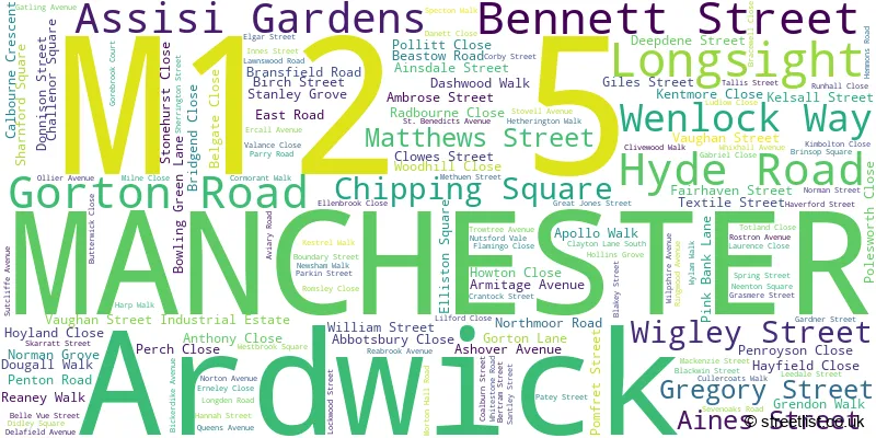
The largest settlements in the M12 5 postal code are MANCHESTER and Longsight.
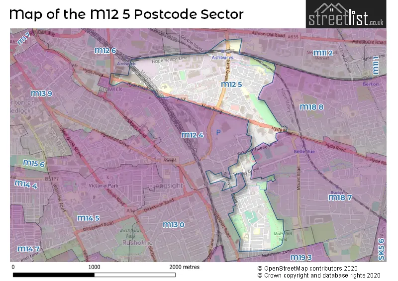
The M12 5 Postcode shares a border with M11 2 (MANCHESTER, Openshaw), M11 3 (MANCHESTER), M12 6 (MANCHESTER, Ardwick), M18 7 (MANCHESTER, Gorton), M12 4 (MANCHESTER, Longsight, Ardwick) and M18 8 (MANCHESTER, Abbey Hey).
The sector is within the post town of MANCHESTER.
M12 5 is a postcode sector within the M12 postcode district which is within the M Manchester postcode area.
The Royal Mail delivery office for the M12 5 postal sector is the South East (m) Delivery Office.
The area of the M12 5 postcode sector is 0.69 square miles which is 1.78 square kilometres or 440.73 square acres.

Map of the M12 5 Postcode Sector
Explore the M12 5 postcode sector by using our free interactive map.
| M | 1 | 2 | - | 5 | X | X |
| M | 1 | 2 | Space | 5 | Letter | Letter |
Official List of Streets
MANCHESTER (137 Streets)
Longsight (4 Streets)
Ardwick (1 Streets)
Unofficial Streets or Alternative Spellings
Longsight
PRESTAGE STREETMANCHESTER
ANTILLES CLOSE BARNBY STREET BONCHURCH WALK CULAND STREET DAMIEN STREET DEVONSHIRE STREET DEVONSHIRE STREET NORTH ELLEN WILKINSON CRESCENT ELSHAM GARDENS GLENCASTLE ROAD GOREBROOK COURT HARVARD ROAD KIRKMANSHULME LANE MAIDA STREET MANBY ROAD MELLING STREET NEWDALE ROAD PROUT STREET PURCELL STREET QUEENSLAND ROAD REDGATE LANE RUSHFORD STREET SCARCROFT ROAD SEDDON STREET APPLEBY AVENUE BURTREE STREET CORBETT STREET FARNLEY STREET FENTON STREET GREY STREET KEMPLEY CLOSE KNIVETON ROAD MALPAS STREET MILES STREET PATCHETT STREET POTTERY LANE QUEENS GROVE SAINT BENEDICTS AVENUE SHROPSHIRE SQUARE TOLL BAR STREET WHIXALL AVENUE WOODLAND STREETSchools and Places of Education Within the M12 5 Postcode Sector
All Saints Primary School
Community school
Belle Vue Street, Manchester, , M12 5PW
Head: Mrs Gaynor Stubbs
Ofsted Rating: Good
Inspection: 2022-11-09 (537 days ago)
Website: Visit All Saints Primary School Website
Phone: 01612239325
Number of Pupils: 230
Armitage CofE Primary School
Voluntary controlled school
Rostron Avenue, Manchester, , M12 5NP
Head: Mrs Gaynor Stubbs
Ofsted Rating: Outstanding
Inspection: 2019-03-22 (1865 days ago)
Website: Visit Armitage CofE Primary School Website
Phone: 01612734654
Number of Pupils: 487
Crowcroft Park Primary School
Community school
Stovell Avenue, Manchester, , M12 5SY
Head: Mrs Juliet Francis
Ofsted Rating: Good
Inspection: 2021-10-20 (922 days ago)
Website: Visit Crowcroft Park Primary School Website
Phone: 01612245914
Number of Pupils: 241
Progress Schools - Gorton
Other independent school
Hideout Youth Zone, , , M12 5PX
Head: Mr Emma Kanis
Ofsted Rating: Requires improvement
Inspection: 2022-06-30 (669 days ago)
Website: Visit Progress Schools - Gorton Website
Phone: 01615439767
Number of Pupils: 1
St Richard's RC Primary School
Voluntary aided school
Wilpshire Avenue, Manchester, , M12 5TL
Head: Mr Jonathan Murray
Ofsted Rating: Outstanding
Inspection: 2012-06-14 (4337 days ago)
Website: Visit St Richard's RC Primary School Website
Phone: 01612245552
Number of Pupils: 474
House Prices in the M12 5 Postcode Sector
| Type of Property | 2018 Average | 2018 Sales | 2017 Average | 2017 Sales | 2016 Average | 2016 Sales | 2015 Average | 2015 Sales |
|---|---|---|---|---|---|---|---|---|
| Detached | £214,305 | 21 | £204,493 | 20 | £179,163 | 12 | £168,996 | 10 |
| Semi-Detached | £177,656 | 47 | £162,402 | 61 | £145,738 | 58 | £124,948 | 46 |
| Terraced | £116,215 | 68 | £111,070 | 67 | £106,804 | 74 | £100,316 | 69 |
| Flats | £118,249 | 8 | £102,723 | 11 | £82,325 | 4 | £69,814 | 7 |
Important Postcodes M12 5 in the Postcode Sector
M12 5DH is the postcode for Manchester City Council, Wenlock Way Offices, Wenlock Way
M12 5DX is the postcode for Unit 2 Ashbury Works, Gorton Road
M12 5JY is the postcode for Gorton Clinic, 46-48 Blackwin Street
M12 5LF is the postcode for Carisbrook Resource Centre, Wenlock Way
M12 5LH is the postcode for West Gorton Medical Centre, Frodsley Walk
M12 5LZ is the postcode for St. Francis RC Primary School, Ellenbrook Close, and MAIN BUILDING, St. Francis RC Primary School, Ellenbrook Close
M12 5NP is the postcode for Armitage C of E Primary School, Rostron Avenue, and Nursery & Community Centre, Armitage C of E Primary School, Rostron Avenue
M12 5PW is the postcode for All Saints Primary School, Belle Vue Street
M12 5QN is the postcode for Manchester City Council, Pink Bank Lane
M12 5SY is the postcode for Crowcroft Park Primary School, Stovell Avenue
M12 5TL is the postcode for EARLY YEARS FOUNDATION BLOCK, St. Richards RC Primary School, Wilpshire Avenue, OLYMPIC BLOCK, St. Richards RC Primary School, Wilpshire Avenue, St. Richards RC Primary School, Wilpshire Avenue, MAIN BUILDING, St. Richards RC Primary School, Wilpshire Avenue, and ST. RICHARDS BUILDING, St. Richards RC Primary School, Wilpshire Avenue
| The M12 5 Sector is within these Local Authorities |
|
|---|---|
| The M12 5 Sector is within these Counties |
|
| The M12 5 Sector is within these Water Company Areas |
|