The M18 8 postcode sector is within the county of Greater Manchester.
Did you know? According to the 2021 Census, the M18 8 postcode sector is home to a bustling 12,127 residents!
Given that each sector allows for 400 unique postcode combinations. Letters C, I, K, M, O and V are not allowed in the last two letters of a postcode. With 289 postcodes already in use, this leaves 111 units available.
The largest settlements in the M18 8 postal code are MANCHESTER and Abbey Hey.
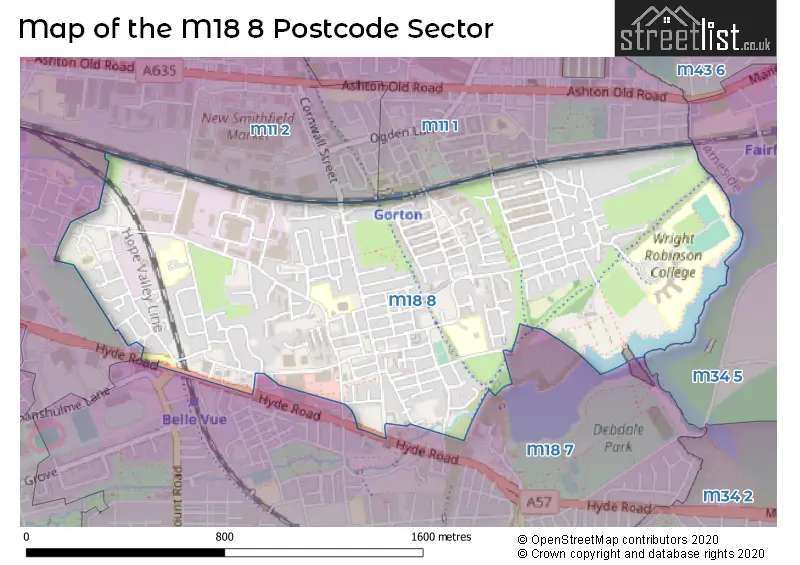
The M18 8 Postcode shares a border with M11 1 (MANCHESTER, Openshaw), M11 2 (MANCHESTER, Openshaw), M18 7 (MANCHESTER, Gorton), M34 5 (Audenshaw) and M12 5 (MANCHESTER, Longsight).
The sector is within the post town of MANCHESTER.
M18 8 is a postcode sector within the M18 postcode district which is within the M Manchester postcode area.
The Royal Mail delivery office for the M18 8 postal sector is the South East (m) Delivery Office.
The area of the M18 8 postcode sector is 0.80 square miles which is 2.08 square kilometres or 514.25 square acres.

Map of the M18 8 Postcode Sector
Explore the M18 8 postcode sector by using our free interactive map.
| M | 1 | 8 | - | 8 | X | X |
| M | 1 | 8 | Space | 8 | Letter | Letter |
Official List of Streets
Abbey Hey (8 Streets)
MANCHESTER (196 Streets)
Gorton (1 Streets)
Unofficial Streets or Alternative Spellings
MANCHESTER
CORNWALL STREET GABRIEL CLOSE GLENCASTLE ROAD HYDE ROAD KNUTSFORD ROAD MOUNT ROAD SIR GERALD KAUFMAN CLOSE SUNNY BROW ROAD ALDCROFT STREET ARTHERFIELD CLOSE BELLAMY COURT BURSTON STREET CHAPMAN MEWS ENCOTT CLOSE FALLOWFIELD LOOP FOLLOWS STREET FROXMER STREET GREEN LANE HARP WALK HORATIO STREET MARCHIONESS STREET ROBERTSON CLOSE RYLANDS STREET THORNBURY WAY TOWEY CLOSE VAREY STREET WHITWELL WAYGorton
WILLIAMS ROADWeather Forecast for M18 8
Press Button to Show Forecast for Debdale
| Time Period | Icon | Description | Temperature | Rain Probability | Wind |
|---|---|---|---|---|---|
| 03:00 to 06:00 | Cloudy | 7.0°C (feels like 4.0°C) | 47.00% | S 13 mph | |
| 06:00 to 09:00 | Cloudy | 8.0°C (feels like 5.0°C) | 15.00% | S 11 mph | |
| 09:00 to 12:00 | Cloudy | 11.0°C (feels like 8.0°C) | 7.00% | S 16 mph | |
| 12:00 to 15:00 | Cloudy | 12.0°C (feels like 9.0°C) | 41.00% | S 18 mph | |
| 15:00 to 18:00 | Light rain | 12.0°C (feels like 9.0°C) | 50.00% | S 16 mph | |
| 18:00 to 21:00 | Light rain | 11.0°C (feels like 9.0°C) | 45.00% | S 16 mph | |
| 21:00 to 00:00 | Cloudy | 11.0°C (feels like 8.0°C) | 11.00% | S 13 mph |
Press Button to Show Forecast for Debdale
| Time Period | Icon | Description | Temperature | Rain Probability | Wind |
|---|---|---|---|---|---|
| 00:00 to 03:00 | Cloudy | 10.0°C (feels like 8.0°C) | 11.00% | SSE 13 mph | |
| 03:00 to 06:00 | Cloudy | 9.0°C (feels like 7.0°C) | 4.00% | SE 11 mph | |
| 06:00 to 09:00 | Cloudy | 9.0°C (feels like 6.0°C) | 4.00% | SE 13 mph | |
| 09:00 to 12:00 | Partly cloudy (day) | 12.0°C (feels like 10.0°C) | 1.00% | SE 16 mph | |
| 12:00 to 15:00 | Partly cloudy (day) | 16.0°C (feels like 12.0°C) | 5.00% | SSE 16 mph | |
| 15:00 to 18:00 | Cloudy | 16.0°C (feels like 13.0°C) | 9.00% | SSE 13 mph | |
| 18:00 to 21:00 | Cloudy | 14.0°C (feels like 12.0°C) | 12.00% | S 9 mph | |
| 21:00 to 00:00 | Cloudy | 12.0°C (feels like 11.0°C) | 12.00% | SSE 7 mph |
Press Button to Show Forecast for Debdale
| Time Period | Icon | Description | Temperature | Rain Probability | Wind |
|---|---|---|---|---|---|
| 00:00 to 03:00 | Cloudy | 10.0°C (feels like 9.0°C) | 13.00% | SSE 4 mph | |
| 03:00 to 06:00 | Cloudy | 9.0°C (feels like 8.0°C) | 8.00% | SE 4 mph | |
| 06:00 to 09:00 | Cloudy | 9.0°C (feels like 8.0°C) | 6.00% | SE 4 mph | |
| 09:00 to 12:00 | Cloudy | 12.0°C (feels like 11.0°C) | 6.00% | SE 4 mph | |
| 12:00 to 15:00 | Cloudy | 14.0°C (feels like 14.0°C) | 10.00% | ESE 4 mph | |
| 15:00 to 18:00 | Cloudy | 16.0°C (feels like 15.0°C) | 10.00% | E 4 mph | |
| 18:00 to 21:00 | Cloudy | 15.0°C (feels like 14.0°C) | 8.00% | WNW 7 mph | |
| 21:00 to 00:00 | Cloudy | 13.0°C (feels like 12.0°C) | 9.00% | WNW 7 mph |
Press Button to Show Forecast for Debdale
| Time Period | Icon | Description | Temperature | Rain Probability | Wind |
|---|---|---|---|---|---|
| 00:00 to 03:00 | Cloudy | 11.0°C (feels like 10.0°C) | 11.00% | N 7 mph | |
| 03:00 to 06:00 | Cloudy | 10.0°C (feels like 9.0°C) | 9.00% | N 7 mph | |
| 06:00 to 09:00 | Partly cloudy (day) | 11.0°C (feels like 9.0°C) | 4.00% | N 7 mph | |
| 09:00 to 12:00 | Partly cloudy (day) | 13.0°C (feels like 11.0°C) | 4.00% | NNE 9 mph | |
| 12:00 to 15:00 | Sunny day | 16.0°C (feels like 14.0°C) | 4.00% | NNE 11 mph | |
| 15:00 to 18:00 | Sunny day | 18.0°C (feels like 15.0°C) | 5.00% | NNE 11 mph | |
| 18:00 to 21:00 | Sunny day | 16.0°C (feels like 14.0°C) | 4.00% | NNE 11 mph | |
| 21:00 to 00:00 | Clear night | 12.0°C (feels like 11.0°C) | 2.00% | NNE 9 mph |
Schools and Places of Education Within the M18 8 Postcode Sector
Abbey Hey Primary Academy
Academy sponsor led
Abbey Hey Lane, Manchester, Greater Manchester, M18 8PF
Head: Mr Paul Graham
Ofsted Rating: Good
Inspection: 2019-10-02 (1671 days ago)
Website: Visit Abbey Hey Primary Academy Website
Phone: 01612231592
Number of Pupils: 665
St James' CofE Primary School Gorton
Academy sponsor led
Stelling Street, Manchester, , M18 8LW
Head: Mr Michael Connolly
Ofsted Rating: Good
Inspection: 2023-05-05 (360 days ago)
Website: Visit St James' CofE Primary School Gorton Website
Phone: 01612232423
Number of Pupils: 452
Wright Robinson College
Academy converter
Abbey Hey Lane, Manchester, , M18 8RL
Head: Mr Martin Haworth
Ofsted Rating: Outstanding
Inspection: 2021-10-07 (935 days ago)
Website: Visit Wright Robinson College Website
Phone: 01613705121
Number of Pupils: 1826
House Prices in the M18 8 Postcode Sector
| Type of Property | 2018 Average | 2018 Sales | 2017 Average | 2017 Sales | 2016 Average | 2016 Sales | 2015 Average | 2015 Sales |
|---|---|---|---|---|---|---|---|---|
| Detached | £222,109 | 11 | £238,333 | 3 | £219,500 | 2 | £0 | 0 |
| Semi-Detached | £145,267 | 79 | £108,136 | 36 | £99,180 | 41 | £94,602 | 24 |
| Terraced | £89,219 | 113 | £79,136 | 112 | £74,700 | 122 | £70,300 | 101 |
| Flats | £170,000 | 1 | £114,875 | 4 | £36,907 | 3 | £61,000 | 2 |
Important Postcodes M18 8 in the Postcode Sector
M18 8AX is the postcode for Diversity & Inclusion Team, Peacock Centre, Peacock Close
M18 8DB is the postcode for Unit B, Delta Industrial Estate
M18 8EQ is the postcode for Manchester City Council, Hammerstone Road, and Coca Cola Building, Operational Services
M18 8GD is the postcode for Abbey Hey Clinic, Constable Street
M18 8HE is the postcode for Manchester Regional Gymnastics Centre, Garratt Way, City of Manchester Institute of Gymnastics, Garratt Way, Belle Vue House, 27 Garratt Way, and Manchester City Council, Gorton Library, Garratt Way
M18 8LW is the postcode for St. James Primary School, Stelling Street, ST James Primary School KS2, Stelling Street, St. James Primary School Main Block, Stelling Street, and St James Primary School KS2, Stelling Street
M18 8PF is the postcode for Abbey Hey Academy, Abbey Hey Lane, and MAIN BUILDING, Abbey Hey Academy, Abbey Hey Lane
M18 8RL is the postcode for Wright Robinson High School, Abbey Hey Lane, WRIGHT ROBINSON HIGH SCHOOL MANCHESTER, Wright Robinson High School, Abbey Hey Lane, and Wright Robinson Specialist College, Abbey Hey Lane
| The M18 8 Sector is within these Local Authorities |
|
|---|---|
| The M18 8 Sector is within these Counties |
|
| The M18 8 Sector is within these Water Company Areas |
|