The M20 1 postcode sector is within the county of Greater Manchester.
Did you know? According to the 2021 Census, the M20 1 postcode sector is home to a bustling 8,572 residents!
Given that each sector allows for 400 unique postcode combinations. Letters C, I, K, M, O and V are not allowed in the last two letters of a postcode. With 186 postcodes already in use, this leaves 214 units available.
The largest settlements in the M20 1 postal code are MANCHESTER and Withington.
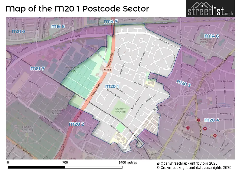
The M20 1 Postcode shares a border with M20 2 (MANCHESTER, Didsbury), M21 7 (MANCHESTER, Chorlton Cum Hardy), M14 6 (MANCHESTER, Fallowfield), M14 7 (MANCHESTER, Rusholme, Fallowfield), M20 3 (MANCHESTER, Withington) and M20 4 (MANCHESTER, Withington).
The sector is within the post town of MANCHESTER.
M20 1 is a postcode sector within the M20 postcode district which is within the M Manchester postcode area.
The Royal Mail delivery office for the M20 1 postal sector is the Manchester South Delivery Office.
The area of the M20 1 postcode sector is 0.52 square miles which is 1.35 square kilometres or 332.51 square acres.

Map of the M20 1 Postcode Sector
Explore the M20 1 postcode sector by using our free interactive map.
| M | 2 | 0 | - | 1 | X | X |
| M | 2 | 0 | Space | 1 | Letter | Letter |
Official List of Streets
MANCHESTER (92 Streets)
Withington (5 Streets)
Didsbury (1 Streets)
Unofficial Streets or Alternative Spellings
MANCHESTER
ASHFORD ROAD BIRCHINGTON ROAD CENTRAL ROAD EVERETT ROAD GOULDEN ROAD HESWALL AVENUE HOUGH ROAD LAPWING LANE LONGTON AVENUE MONTMANO DRIVE MOORDALE STREET NESTON AVENUE ORCHARD GROVE PANDORA STREET THE BOULEVARD YEW TREE ROAD FALLOWFIELD LOOP FRAMLEY ROAD STOW GARDENSChorlton Cum Hardy
MAULDETH ROAD WESTSchools and Places of Education Within the M20 1 Postcode Sector
Cavendish Primary School
Community school
Cavendish Road, Manchester, Greater Manchester, M20 1JG
Head: Mrs J Taylor
Ofsted Rating: Good
Inspection: 2019-05-01 (1849 days ago)
Website: Visit Cavendish Primary School Website
Phone: 01614451815
Number of Pupils: 702
House Prices in the M20 1 Postcode Sector
| Type of Property | 2018 Average | 2018 Sales | 2017 Average | 2017 Sales | 2016 Average | 2016 Sales | 2015 Average | 2015 Sales |
|---|---|---|---|---|---|---|---|---|
| Detached | £472,724 | 11 | £420,000 | 1 | £412,000 | 3 | £332,500 | 2 |
| Semi-Detached | £284,599 | 42 | £259,477 | 36 | £227,221 | 50 | £186,318 | 37 |
| Terraced | £315,408 | 45 | £280,877 | 49 | £279,327 | 44 | £253,583 | 48 |
| Flats | £255,332 | 40 | £183,352 | 23 | £164,861 | 39 | £172,383 | 24 |
Important Postcodes M20 1 in the Postcode Sector
M20 1DE is the postcode for Old Moat Sure Start Centre, Old Moat Lane
M20 1EB is the postcode for The Borchardt Medical Centre, 62 Whitchurch Road
M20 1FQ is the postcode for 91, Dermot Murphy Close
M20 1FW is the postcode for 2, Minehead Avenue, and Manchester City Council, Minehead Centre, Minehead Avenue
M20 1JG is the postcode for MAIN BLOCK, Cavendish Road Primary School, Cavendish Road, Cavendish Road Primary School, Cavendish Road, RHODES BUILDING, Cavendish Road Primary School, Cavendish Road, and NURSERY BUILDING, Cavendish Road Primary School, Cavendish Road
M20 1NA is the postcode for Hough End Leisure Centre, 480 Princess Road
| The M20 1 Sector is within these Local Authorities |
|
|---|---|
| The M20 1 Sector is within these Counties |
|
| The M20 1 Sector is within these Water Company Areas |
|