The MK14 6 postcode sector is within the county of Buckinghamshire.
Did you know? According to the 2021 Census, the MK14 6 postcode sector is home to a bustling 7,339 residents!
Given that each sector allows for 400 unique postcode combinations. Letters C, I, K, M, O and V are not allowed in the last two letters of a postcode. With 158 postcodes already in use, this leaves 242 units available.
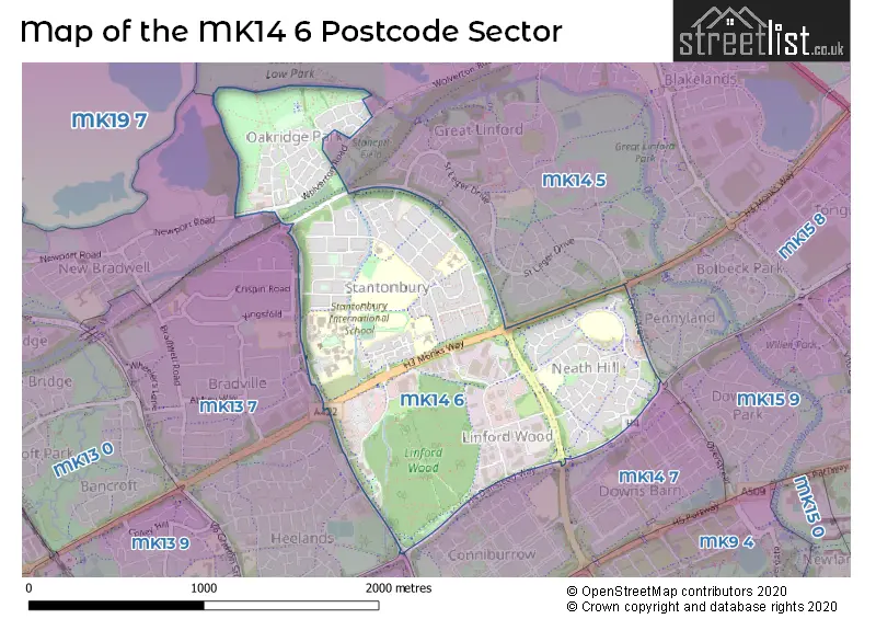
The largest settlement in the MK14 6 postal code is Stantonbury followed by Neath Hill, and Oakridge Park.
The MK14 6 Postcode shares a border with MK13 8 (Bradwell Common, Rooksley), MK14 5 (Great Linford, Giffard Park, Redhouse Park), MK14 7 (Conniburrow, Downs Barn), MK15 8 (Pennyland, Bolbeck Park, Tongwell), MK13 0 (New Bradwell, Bancroft, Blue Bridge) and MK13 7 (Bradville, Heelands).
The sector is within the post town of MILTON KEYNES.
MK14 6 is a postcode sector within the MK1 postcode district which is within the MK Milton Keynes postcode area.
The Royal Mail delivery office for the MK14 6 postal sector is the unknown.
The area of the MK14 6 postcode sector is 1.15 square miles which is 2.99 square kilometres or 738.84 square acres.
Waterways within the MK14 6 postcode sector include the Grand Union Canal.

Map of the MK14 6 Postcode Sector
Explore the MK14 6 postcode sector by using our free interactive map.
| M | K | 1 | 4 | - | 6 | X | X |
| M | K | 1 | 4 | Space | 6 | Letter | Letter |
Official List of Streets
Oakridge Park (28 Streets)
Neath Hill (36 Streets)
Stantonbury (26 Streets)
Linford Wood (10 Streets)
Stantonbury Fields (5 Streets)
Unofficial Streets or Alternative Spellings
Blakelands
MONKS WAY WOLVERTON ROADCrownhill
DANSTEED WAYPennyland
SOVEREIGN DRIVEConniburrow
FENNEL DRIVEHeelands
EAST DALES LEYBURN COURTNew Bradwell
NEWPORT ROAD TOWNSEND GROVEWeather Forecast for MK14 6
Press Button to Show Forecast for Great Linford
| Time Period | Icon | Description | Temperature | Rain Probability | Wind |
|---|---|---|---|---|---|
| 18:00 to 21:00 | Cloudy | 15.0°C (feels like 15.0°C) | 4.00% | SW 2 mph | |
| 21:00 to 00:00 | Partly cloudy (night) | 12.0°C (feels like 11.0°C) | 1.00% | S 4 mph |
Press Button to Show Forecast for Great Linford
| Time Period | Icon | Description | Temperature | Rain Probability | Wind |
|---|---|---|---|---|---|
| 00:00 to 03:00 | Partly cloudy (night) | 10.0°C (feels like 9.0°C) | 0.00% | SSW 4 mph | |
| 03:00 to 06:00 | Partly cloudy (night) | 8.0°C (feels like 7.0°C) | 0.00% | SSW 4 mph | |
| 06:00 to 09:00 | Partly cloudy (day) | 8.0°C (feels like 8.0°C) | 0.00% | SW 2 mph | |
| 09:00 to 12:00 | Sunny day | 14.0°C (feels like 14.0°C) | 0.00% | S 2 mph | |
| 12:00 to 15:00 | Cloudy | 16.0°C (feels like 15.0°C) | 5.00% | SSE 7 mph | |
| 15:00 to 18:00 | Cloudy | 18.0°C (feels like 16.0°C) | 4.00% | SE 7 mph | |
| 18:00 to 21:00 | Cloudy | 16.0°C (feels like 15.0°C) | 5.00% | S 4 mph | |
| 21:00 to 00:00 | Cloudy | 12.0°C (feels like 12.0°C) | 5.00% | SSW 2 mph |
Press Button to Show Forecast for Great Linford
| Time Period | Icon | Description | Temperature | Rain Probability | Wind |
|---|---|---|---|---|---|
| 00:00 to 03:00 | Cloudy | 11.0°C (feels like 11.0°C) | 5.00% | SSE 2 mph | |
| 03:00 to 06:00 | Cloudy | 10.0°C (feels like 9.0°C) | 5.00% | NE 2 mph | |
| 06:00 to 09:00 | Cloudy | 10.0°C (feels like 10.0°C) | 9.00% | NNE 4 mph | |
| 09:00 to 12:00 | Light rain | 13.0°C (feels like 12.0°C) | 46.00% | NE 7 mph | |
| 12:00 to 15:00 | Light rain shower (day) | 15.0°C (feels like 14.0°C) | 29.00% | NE 9 mph | |
| 15:00 to 18:00 | Light rain shower (day) | 16.0°C (feels like 14.0°C) | 29.00% | ENE 7 mph | |
| 18:00 to 21:00 | Light rain shower (day) | 15.0°C (feels like 13.0°C) | 28.00% | NE 7 mph | |
| 21:00 to 00:00 | Cloudy | 12.0°C (feels like 11.0°C) | 6.00% | NE 4 mph |
Press Button to Show Forecast for Great Linford
| Time Period | Icon | Description | Temperature | Rain Probability | Wind |
|---|---|---|---|---|---|
| 00:00 to 03:00 | Clear night | 10.0°C (feels like 9.0°C) | 1.00% | NNW 4 mph | |
| 03:00 to 06:00 | Clear night | 9.0°C (feels like 8.0°C) | 1.00% | NW 4 mph | |
| 06:00 to 09:00 | Partly cloudy (day) | 10.0°C (feels like 8.0°C) | 3.00% | NW 7 mph | |
| 09:00 to 12:00 | Sunny day | 14.0°C (feels like 13.0°C) | 1.00% | NNW 7 mph | |
| 12:00 to 15:00 | Sunny day | 17.0°C (feels like 16.0°C) | 2.00% | N 7 mph | |
| 15:00 to 18:00 | Cloudy | 18.0°C (feels like 17.0°C) | 7.00% | NNW 7 mph | |
| 18:00 to 21:00 | Cloudy | 17.0°C (feels like 16.0°C) | 6.00% | N 7 mph | |
| 21:00 to 00:00 | Partly cloudy (night) | 13.0°C (feels like 12.0°C) | 1.00% | NNE 7 mph |
Press Button to Show Forecast for Great Linford
| Time Period | Icon | Description | Temperature | Rain Probability | Wind |
|---|---|---|---|---|---|
| 00:00 to 03:00 | Partly cloudy (night) | 10.0°C (feels like 9.0°C) | 1.00% | NNE 4 mph | |
| 03:00 to 06:00 | Cloudy | 9.0°C (feels like 8.0°C) | 5.00% | NNE 4 mph | |
| 06:00 to 09:00 | Overcast | 10.0°C (feels like 8.0°C) | 8.00% | NNE 4 mph | |
| 09:00 to 12:00 | Overcast | 13.0°C (feels like 12.0°C) | 7.00% | NE 4 mph | |
| 12:00 to 15:00 | Cloudy | 16.0°C (feels like 16.0°C) | 5.00% | ENE 4 mph | |
| 15:00 to 18:00 | Cloudy | 18.0°C (feels like 17.0°C) | 4.00% | NE 4 mph | |
| 18:00 to 21:00 | Cloudy | 17.0°C (feels like 17.0°C) | 5.00% | NE 4 mph | |
| 21:00 to 00:00 | Cloudy | 14.0°C (feels like 13.0°C) | 4.00% | SSE 4 mph |
Schools and Places of Education Within the MK14 6 Postcode Sector
St Monica's Catholic Primary School
Voluntary aided school
Currier Drive, Milton Keynes, Buckinghamshire, MK14 6HB
Head: Ms Natalie Shanahan
Ofsted Rating: Good
Inspection: 2018-11-28 (1984 days ago)
Website: Visit St Monica's Catholic Primary School Website
Phone: 01908606966
Number of Pupils: 397
Stephenson Academy
Academy special sponsor led
Crosslands, Milton Keynes, Buckinghamshire, MK14 6AX
Head: Dr Marie Ramsay
Ofsted Rating: Good
Inspection: 2018-12-05 (1977 days ago)
Website: Visit Stephenson Academy Website
Phone: 01908889400
Number of Pupils: 92
Wood End Infant & Pre-School
Community school
Redbridge, Milton Keynes, Buckinghamshire, MK14 6BB
Head: Mrs Claire Wilson
Ofsted Rating: Good
Inspection: 2022-03-30 (766 days ago)
Website: Visit Wood End Infant & Pre-School Website
Phone: 01908316424
Number of Pupils: 69
House Prices in the MK14 6 Postcode Sector
| Type of Property | 2018 Average | 2018 Sales | 2017 Average | 2017 Sales | 2016 Average | 2016 Sales | 2015 Average | 2015 Sales |
|---|---|---|---|---|---|---|---|---|
| Detached | £354,152 | 24 | £396,600 | 25 | £357,093 | 29 | £298,442 | 26 |
| Semi-Detached | £272,247 | 17 | £271,616 | 21 | £242,558 | 26 | £232,911 | 27 |
| Terraced | £243,710 | 29 | £224,097 | 41 | £250,442 | 47 | £193,022 | 45 |
| Flats | £149,000 | 9 | £147,567 | 15 | £130,806 | 16 | £121,340 | 15 |
Important Postcodes MK14 6 in the Postcode Sector
MK14 6AX is the postcode for BLOCK B, The Stephenson Academy, Crosslands, The Stephenson Academy, Crosslands, and BLOCK A, The Stephenson Academy, Crosslands
MK14 6BB is the postcode for Wood End First School, Redbridge, Stantonbury
MK14 6BL is the postcode for Stantonbury Health Centre, Purbeck, Stantonbury Centre
MK14 6BN is the postcode for ACTIVITIES, Stantonbury Campus, Purbeck, DANSTEED 1, Stantonbury Campus, Purbeck, DANSTEED 2, Stantonbury Campus, Purbeck, COOKSEY, Stantonbury Campus, Purbeck, GRAFTON 1, Stantonbury Campus, Purbeck, THEATRE/GALLERY, Stantonbury Campus, Purbeck, UPPER LEVEL, Stantonbury Campus, Purbeck, COOKSEY 3, Stantonbury Campus, Purbeck, BRIGHOUSE, Stantonbury Campus, Purbeck, UPPER, Stantonbury Campus, Purbeck, ASHURST, Stantonbury Campus, Purbeck, LEISURE CENTRE, Stantonbury Campus, Purbeck, FIELDING / DINING, Stantonbury Campus, Purbeck, COOKSEY 1, Stantonbury Campus, Purbeck, Stantonbury Campus, Purbeck, SAXON / DINER, Stantonbury Campus, Purbeck, GRAFTON, Stantonbury Campus, Purbeck, COOKSEY 2, Stantonbury Campus, Purbeck, FIELDING, Stantonbury Campus, Purbeck, THE HUB & WELLBEING, Stantonbury Campus, Purbeck, PORTWAY, Stantonbury Campus, Purbeck, DINING ROOM, Stantonbury Campus, Purbeck, and GRAFTON 2, Stantonbury Campus, Purbeck
MK14 6DY is the postcode for N H S Direct Call Centre, Marlborough Court, Sunrise Parkway
MK14 6GL is the postcode for Oakridge Park Health Centre, 30 Texel Close
MK14 6HB is the postcode for St. Monicas School, Currier Drive, St. Monicas School, Currier Drive, Neath Hill, C T A L D, Currier Drive, and St Monicas Catholic Primary School, Currier Drive, Neath Hill
MK14 6JY is the postcode for Neath Hill Health Centre, 1 Tower Crescent, Tower Drive
MK14 6JZ is the postcode for THE BROOKSIDE BUILDING, Brooksward Combined School, Tower Drive, Brooksward Combined School, Tower Drive, and RIVERSIDE BUILDING, Brooksward Combined School, Tower Drive
MK14 6NA is the postcode for Tower Drive Centre, Tower Drive
| The MK14 6 Sector is within these Local Authorities |
|
|---|---|
| The MK14 6 Sector is within these Counties |
|
| The MK14 6 Sector is within these Water Company Areas |
|