The NE3 1 postcode sector is within the county of Tyne & Wear.
Did you know? According to the 2021 Census, the NE3 1 postcode sector is home to a bustling 8,621 residents!
Given that each sector allows for 400 unique postcode combinations. Letters C, I, K, M, O and V are not allowed in the last two letters of a postcode. With 208 postcodes already in use, this leaves 192 units available.
The largest settlement in the NE3 1 postal code is NEWCASTLE UPON TYNE followed by Gosforth, and South Gosforth.
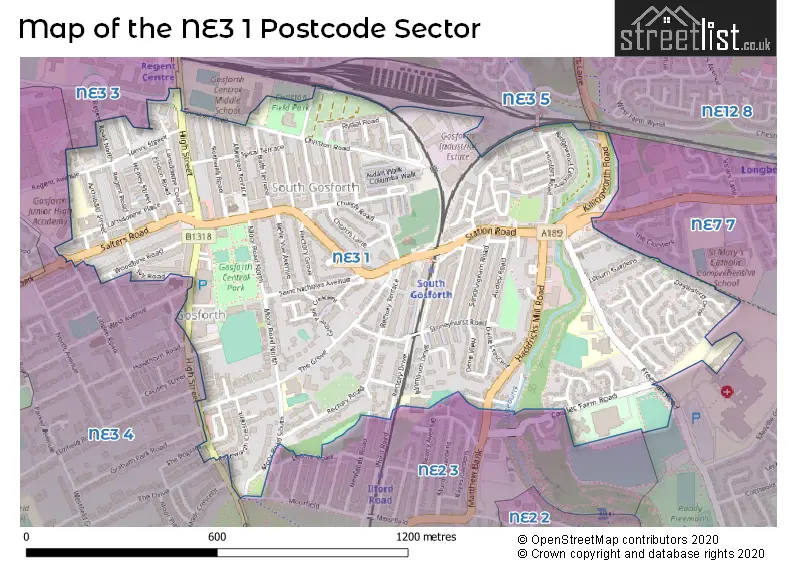
The NE3 1 Postcode shares a border with NE2 3 (NEWCASTLE UPON TYNE, West Jesmond, Jesmond), NE3 3 (NEWCASTLE UPON TYNE, Gosforth), NE3 4 (NEWCASTLE UPON TYNE, Gosforth, Kenton), NE3 5 (NEWCASTLE UPON TYNE, Gosforth, High Gosforth Park), NE12 8 (NEWCASTLE UPON TYNE, Longbenton, Benton) and NE7 7 (NEWCASTLE UPON TYNE, High Heaton, Benton).
The sector is within the post town of NEWCASTLE UPON TYNE.
NE3 1 is a postcode sector within the NE3 postcode district which is within the NE Newcastle upon Tyne postcode area.
The Royal Mail delivery office for the NE3 1 postal sector is the Gosforth Delivery Office.
The area of the NE3 1 postcode sector is 0.64 square miles which is 1.65 square kilometres or 407.80 square acres.
Waterways within the NE3 1 postcode sector include the Ouseburn.

Map of the NE3 1 Postcode Sector
Explore the NE3 1 postcode sector by using our free interactive map.
| N | E | 3 | - | 1 | X | X |
| N | E | 3 | Space | 1 | Letter | Letter |
Official List of Streets
NEWCASTLE UPON TYNE (98 Streets)
Gosforth (29 Streets)
Unofficial Streets or Alternative Spellings
NEWCASTLE UPON TYNE
BENTON PARK ROAD GRAHAM PARK ROAD ILFORD ROAD LODORE ROAD MOORFIELD NEWLANDS ROAD WOODBINE AVENUEHigh Heaton
FREEMAN ROADGosforth
LINDEN ROAD REGENT FARM ROAD THE DRIVE THE POPLARS WEST AVENUEBrunton Park
GREAT NORTH ROADJesmond
MATTHEW BANKSchools and Places of Education Within the NE3 1 Postcode Sector
Archbishop Runcie CofE First School
Voluntary aided school
Christon Road, Newcastle-upon-Tyne, Tyne and Wear, NE3 1US
Head: Mrs Kate Massey
Ofsted Rating: Good
Inspection: 2019-06-26 (1805 days ago)
Website: Visit Archbishop Runcie CofE First School Website
Phone: 01912852663
Number of Pupils: 176
Archibald First School
Foundation school
Archibald Street, Newcastle-upon-Tyne, Tyne and Wear, NE3 1EB
Head: Mrs Rebecca Turner
Ofsted Rating: Outstanding
Inspection: 2015-04-01 (3352 days ago)
Website: Visit Archibald First School Website
Phone: 01912851957
Number of Pupils: 337
Gosforth Central Middle School
Foundation school
Great North Road, Newcastle-upon-Tyne, Tyne and Wear, NE3 1UN
Head: Miss Deeanne Smith
Ofsted Rating: Good
Inspection: 2019-01-16 (1966 days ago)
Website: Visit Gosforth Central Middle School Website
Phone: 01912851793
Number of Pupils: 572
Gosforth Junior High Academy
Academy converter
Regent Avenue, Newcastle-upon-Tyne, Tyne and Wear, NE3 1EE
Head: Principal Ciara Swain
Ofsted Rating: Good
Inspection: 2023-11-08 (209 days ago)
Website: Visit Gosforth Junior High Academy Website
Phone: 01912851000
Number of Pupils: 752
South Gosforth First School
Foundation school
Alnmouth Drive, Newcastle-upon-Tyne, Tyne and Wear, NE3 1YF
Head: Mr Robert Adams
Ofsted Rating: Good
Inspection: 2022-06-29 (706 days ago)
Website: Visit South Gosforth First School Website
Phone: 01912853453
Number of Pupils: 296
House Prices in the NE3 1 Postcode Sector
| Type of Property | 2018 Average | 2018 Sales | 2017 Average | 2017 Sales | 2016 Average | 2016 Sales | 2015 Average | 2015 Sales |
|---|---|---|---|---|---|---|---|---|
| Detached | £494,143 | 7 | £429,438 | 16 | £553,429 | 19 | £377,323 | 17 |
| Semi-Detached | £295,333 | 27 | £317,282 | 30 | £329,686 | 29 | £360,845 | 29 |
| Terraced | £307,888 | 86 | £307,305 | 93 | £321,702 | 88 | £290,217 | 74 |
| Flats | £155,712 | 67 | £152,764 | 74 | £154,191 | 72 | £147,937 | 109 |
Important Postcodes NE3 1 in the Postcode Sector
NE3 1DQ is the postcode for Ridley House, Henry Street
NE3 1EB is the postcode for Archibald First School, Archibald Street
NE3 1EE is the postcode for Gosforth Junior High Academy, Regent Avenue
NE3 1NU is the postcode for The Grove Medical Group, 1 The Grove
NE3 1RR is the postcode for Block A, Bowsden Court, South Gosforth, Block B, Bowsden Court, Block B, Bowsden Court, South Gosforth, and Block A, Bowsden Court
NE3 1SZ is the postcode for Trinity Deneview, Freeman Road, South Gosforth, and Trinity Deneview, Freeman Road
NE3 1TX is the postcode for Gosforth Memorial Medical Centre, Church Road
NE3 1UN is the postcode for Gosforth Central Middle School, Great North Road, Gosforth, and Gosforth Central Middle School, Great North Road
NE3 1XD is the postcode for Archbishop Runcie C of E First School, Christon Road
NE3 1YF is the postcode for South Gosforth First School, Alnmouth Drive
| The NE3 1 Sector is within these Local Authorities |
|
|---|---|
| The NE3 1 Sector is within these Counties |
|
| The NE3 1 Sector is within these Water Company Areas |
|