The NE3 4 postcode sector is within the county of Tyne & Wear.
Did you know? According to the 2021 Census, the NE3 4 postcode sector is home to a bustling 10,605 residents!
Given that each sector allows for 400 unique postcode combinations. Letters C, I, K, M, O and V are not allowed in the last two letters of a postcode. With 242 postcodes already in use, this leaves 158 units available.
The largest settlement in the NE3 4 postal code is NEWCASTLE UPON TYNE followed by Gosforth, and Kenton.
The NE3 4 Postcode shares a border with NE2 3 (NEWCASTLE UPON TYNE, West Jesmond, Jesmond), NE2 4 (NEWCASTLE UPON TYNE, Spital Tongues, Jesmond), NE3 1 (NEWCASTLE UPON TYNE, Gosforth, South Gosforth), NE5 3 (NEWCASTLE UPON TYNE, Cowgate) and NE3 3 (NEWCASTLE UPON TYNE, Gosforth).
The sector is within the post town of NEWCASTLE UPON TYNE.
NE3 4 is a postcode sector within the NE3 postcode district which is within the NE Newcastle upon Tyne postcode area.
The Royal Mail delivery office for the NE3 4 postal sector is the Gosforth Delivery Office.
The area of the NE3 4 postcode sector is 1.20 square miles which is 3.10 square kilometres or 765.78 square acres.

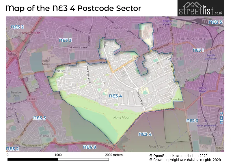
Map of the NE3 4 Postcode Sector
Explore the NE3 4 postcode sector by using our free interactive map.
| N | E | 3 | - | 4 | X | X |
| N | E | 3 | Space | 4 | Letter | Letter |
Official List of Streets
NEWCASTLE UPON TYNE (125 Streets)
Gosforth (17 Streets)
Unofficial Streets or Alternative Spellings
NEWCASTLE UPON TYNE
CARRFIELD ROAD COXLODGE TERRACE LANSDOWNE PLACE MARY AGNES STREET MONTAGU COURT NORTHFIELD ROAD REGENT AVENUE ROSEWORTH CRESCENT ROSEWORTH TERRACE WALL CLOSE WESTWOOD GARDENS WOODBINE ROADGosforth
BACK GROVE AVENUE BARONSWOOD IVY ROAD JUBILEE ROAD ALBANY MEWS ARLINGTON COURT BACK WEST AVENUE BROOKFIELD DODDS FARM ELMFIELD APPROACH ELMTREE GROVE GRANDSTAND ROAD THE RIDGE WAY THORNFIELD ROAD WALL STREET WOODLANDS AVENUEJesmond
GREAT NORTH ROADSchools and Places of Education Within the NE3 4 Postcode Sector
Wyndham Primary School
Academy converter
Wyndsail Place, Newcastle-upon-Tyne, Tyne and Wear, NE3 4QP
Head: Headteacher Rachael Cleary
Ofsted Rating: Good
Inspection: 2019-06-18 (1801 days ago)
Website: Visit Wyndham Primary School Website
Phone: 01912853895
Number of Pupils: 207
House Prices in the NE3 4 Postcode Sector
| Type of Property | 2018 Average | 2018 Sales | 2017 Average | 2017 Sales | 2016 Average | 2016 Sales | 2015 Average | 2015 Sales |
|---|---|---|---|---|---|---|---|---|
| Detached | £709,588 | 17 | £646,763 | 19 | £492,980 | 22 | £619,072 | 29 |
| Semi-Detached | £362,938 | 68 | £395,186 | 74 | £390,333 | 83 | £350,962 | 69 |
| Terraced | £337,986 | 56 | £282,544 | 47 | £311,612 | 49 | £255,143 | 53 |
| Flats | £196,880 | 46 | £211,403 | 56 | £236,148 | 107 | £215,426 | 48 |
Important Postcodes NE3 4 in the Postcode Sector
NE3 4SB is the postcode for Wyndham Primary School, Montagu Avenue
NE3 4TL is the postcode for Harehills Resource Centre, Burnfoot Way
| The NE3 4 Sector is within these Local Authorities |
|
|---|---|
| The NE3 4 Sector is within these Counties |
|
| The NE3 4 Sector is within these Water Company Areas |
|