The NE33 3 postcode sector is within the county of Tyne & Wear.
Did you know? According to the 2021 Census, the NE33 3 postcode sector is home to a bustling 7,437 residents!
Given that each sector allows for 400 unique postcode combinations. Letters C, I, K, M, O and V are not allowed in the last two letters of a postcode. With 165 postcodes already in use, this leaves 235 units available.
The NE33 3 postal code covers the settlement of SOUTH SHIELDS.
The NE33 3 Postcode shares a border with NE33 4 (SOUTH SHIELDS), NE34 7 (SOUTH SHIELDS), NE33 2 (SOUTH SHIELDS), NE34 0 (SOUTH SHIELDS) and NE34 6 (SOUTH SHIELDS).
The sector is within the post town of SOUTH SHIELDS.
NE33 3 is a postcode sector within the NE3 postcode district which is within the NE Newcastle upon Tyne postcode area.
The Royal Mail delivery office for the NE33 3 postal sector is the Gosforth Delivery Office.
The area of the NE33 3 postcode sector is 0.46 square miles which is 1.20 square kilometres or 296.53 square acres.

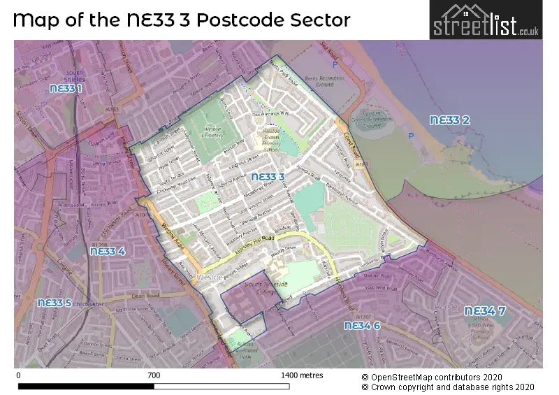
Map of the NE33 3 Postcode Sector
Explore the NE33 3 postcode sector by using our free interactive map.
| N | E | 3 | 3 | - | 3 | X | X |
| N | E | 3 | 3 | Space | 3 | Letter | Letter |
Official List of Streets
SOUTH SHIELDS (85 Streets)
Unofficial Streets or Alternative Spellings
SOUTH SHIELDS,
COAST ROADSOUTH SHIELDS
BRIGHT STREET CHICHESTER ROAD EASTFIELD ROAD GROSVENOR DRIVE HEMSLEY ROAD IMEARY GROVE IMEARY STREET LAVINGTON ROAD NELSON AVENUE ROMILLY STREET SALISBURY PLACE SALISBURY STREET SELBOURNE STREET SHELDON ROAD SOUTH WOODBINE STREET SUNDERLAND ROAD BENTS COTTAGES APPROACH CHICHESTER ROAD EAST EURYALUS COURT SAINT GEORGES AVENUE SAINT MICHAELS AVENUE SAINT MICHAELS AVENUE NORTH SAINT VINCENT STREETSchools and Places of Education Within the NE33 3 Postcode Sector
Westoe Crown Primary School
Community school
Sea Winnings Way, South Shields, Tyne and Wear, NE33 3NS
Head: Mrs Stephanie Proctor
Ofsted Rating: Good
Inspection: 2023-10-11 (225 days ago)
Website: Visit Westoe Crown Primary School Website
Phone: 01914272160
Number of Pupils: 658
House Prices in the NE33 3 Postcode Sector
| Type of Property | 2018 Average | 2018 Sales | 2017 Average | 2017 Sales | 2016 Average | 2016 Sales | 2015 Average | 2015 Sales |
|---|---|---|---|---|---|---|---|---|
| Detached | £157,000 | 1 | £294,000 | 2 | £330,000 | 1 | £416,500 | 3 |
| Semi-Detached | £186,523 | 18 | £177,364 | 15 | £164,750 | 10 | £169,044 | 16 |
| Terraced | £149,040 | 44 | £151,343 | 63 | £139,888 | 44 | £141,287 | 59 |
| Flats | £85,343 | 59 | £93,351 | 61 | £85,207 | 48 | £93,094 | 63 |
Important Postcodes NE33 3 in the Postcode Sector
NE33 3EN is the postcode for South Tyneside College Hall of Residence, Doctor Winterbottom Hall, Grosvenor Road
NE33 3NS is the postcode for Westoe Crown Primary School, Sea Winnings Way
| The NE33 3 Sector is within these Local Authorities |
|
|---|---|
| The NE33 3 Sector is within these Counties |
|
| The NE33 3 Sector is within these Water Company Areas |
|