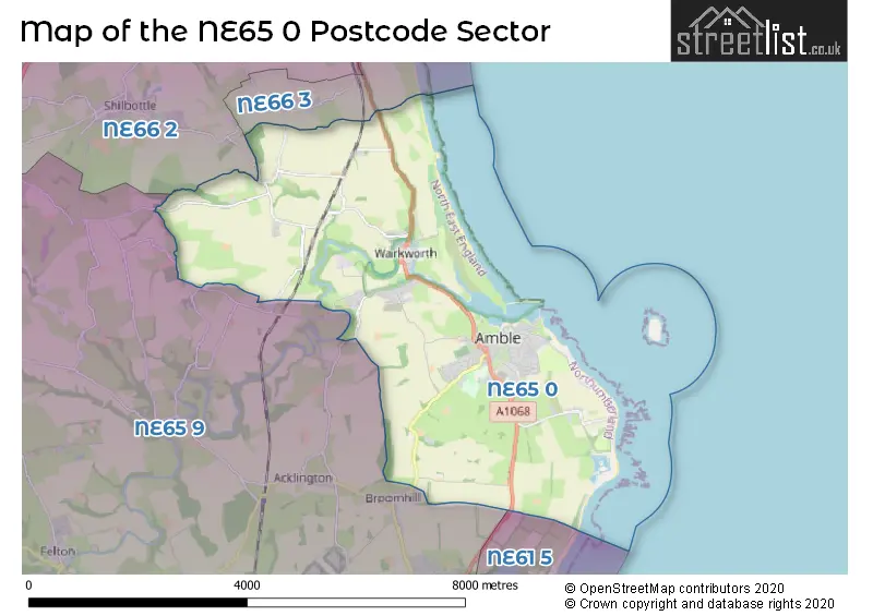
The NE65 0 postcode sector is within the county of Northumberland.
Did you know? According to the 2021 Census, the NE65 0 postcode sector is home to a bustling 7,872 residents!
Given that each sector allows for 400 unique postcode combinations. Letters C, I, K, M, O and V are not allowed in the last two letters of a postcode. With 323 postcodes already in use, this leaves 77 units available.
The largest settlement in the NE65 0 postal code is Amble followed by Warkworth, and High Hauxley.
The NE65 0 Postcode shares a border with NE65 9 (Felton, Hadston, Swarland), NE66 2 (ALNWICK, Shilbottle, Alnmouth), NE66 3 (Longhoughton, Lesbury, Embleton) and NE61 5 (Widdrington, Ellington, Lynemouth).
The sector is within the post town of MORPETH.
NE65 0 is a postcode sector within the NE6 postcode district which is within the NE Newcastle upon Tyne postcode area.
The Royal Mail delivery office for the NE65 0 postal sector is the unknown.
The area of the NE65 0 postcode sector is 11.48 square miles which is 29.73 square kilometres or 7,347.52 square acres.
Waterways within the NE65 0 postcode sector include the Coquet, Grange Burn, Tyelaw Burn.

Map of the NE65 0 Postcode Sector
Explore the NE65 0 postcode sector by using our free interactive map.
| N | E | 6 | 5 | - | 0 | X | X |
| N | E | 6 | 5 | Space | 0 | Letter | Letter |
Official List of Streets
Amble (154 Streets)
Warkworth (48 Streets)
MORPETH (1 Streets)
High Hauxley (1 Streets)
Radcliffe (1 Streets)
Unofficial Streets or Alternative Spellings
Weather Forecast for NE65 0
Press Button to Show Forecast for Warkworth (Beach)
| Time Period | Icon | Description | Temperature | Rain Probability | Wind |
|---|---|---|---|---|---|
| 03:00 to 06:00 | Cloudy | 6.0°C (feels like 3.0°C) | 13.00% | S 9 mph | |
| 06:00 to 09:00 | Cloudy | 7.0°C (feels like 4.0°C) | 14.00% | S 9 mph | |
| 09:00 to 12:00 | Cloudy | 10.0°C (feels like 7.0°C) | 13.00% | S 16 mph | |
| 12:00 to 15:00 | Light rain | 12.0°C (feels like 9.0°C) | 43.00% | S 18 mph | |
| 15:00 to 18:00 | Light rain | 12.0°C (feels like 9.0°C) | 47.00% | S 18 mph | |
| 18:00 to 21:00 | Cloudy | 12.0°C (feels like 9.0°C) | 13.00% | S 18 mph | |
| 21:00 to 00:00 | Cloudy | 11.0°C (feels like 8.0°C) | 8.00% | S 16 mph |
Press Button to Show Forecast for Warkworth (Beach)
| Time Period | Icon | Description | Temperature | Rain Probability | Wind |
|---|---|---|---|---|---|
| 00:00 to 03:00 | Cloudy | 10.0°C (feels like 7.0°C) | 4.00% | S 13 mph | |
| 03:00 to 06:00 | Cloudy | 9.0°C (feels like 6.0°C) | 4.00% | SSE 11 mph | |
| 06:00 to 09:00 | Cloudy | 9.0°C (feels like 6.0°C) | 4.00% | SSE 13 mph | |
| 09:00 to 12:00 | Partly cloudy (day) | 11.0°C (feels like 8.0°C) | 1.00% | SSE 16 mph | |
| 12:00 to 15:00 | Sunny day | 13.0°C (feels like 10.0°C) | 0.00% | SE 16 mph | |
| 15:00 to 18:00 | Partly cloudy (day) | 12.0°C (feels like 9.0°C) | 2.00% | SE 18 mph | |
| 18:00 to 21:00 | Partly cloudy (day) | 11.0°C (feels like 8.0°C) | 2.00% | SE 16 mph | |
| 21:00 to 00:00 | Cloudy | 9.0°C (feels like 7.0°C) | 7.00% | SE 11 mph |
Press Button to Show Forecast for Warkworth (Beach)
| Time Period | Icon | Description | Temperature | Rain Probability | Wind |
|---|---|---|---|---|---|
| 00:00 to 03:00 | Cloudy | 9.0°C (feels like 7.0°C) | 9.00% | SE 9 mph | |
| 03:00 to 06:00 | Cloudy | 9.0°C (feels like 7.0°C) | 10.00% | SE 7 mph | |
| 06:00 to 09:00 | Cloudy | 9.0°C (feels like 8.0°C) | 13.00% | ESE 4 mph | |
| 09:00 to 12:00 | Cloudy | 11.0°C (feels like 9.0°C) | 12.00% | E 7 mph | |
| 12:00 to 15:00 | Cloudy | 11.0°C (feels like 10.0°C) | 11.00% | E 7 mph | |
| 15:00 to 18:00 | Overcast | 11.0°C (feels like 9.0°C) | 11.00% | ENE 9 mph | |
| 18:00 to 21:00 | Overcast | 9.0°C (feels like 8.0°C) | 11.00% | NE 7 mph | |
| 21:00 to 00:00 | Cloudy | 9.0°C (feels like 7.0°C) | 11.00% | N 9 mph |
Press Button to Show Forecast for Warkworth (Beach)
| Time Period | Icon | Description | Temperature | Rain Probability | Wind |
|---|---|---|---|---|---|
| 00:00 to 03:00 | Cloudy | 9.0°C (feels like 6.0°C) | 9.00% | N 11 mph | |
| 03:00 to 06:00 | Overcast | 9.0°C (feels like 6.0°C) | 11.00% | N 13 mph | |
| 06:00 to 09:00 | Cloudy | 9.0°C (feels like 6.0°C) | 8.00% | N 13 mph | |
| 09:00 to 12:00 | Cloudy | 10.0°C (feels like 8.0°C) | 7.00% | N 13 mph | |
| 12:00 to 15:00 | Partly cloudy (day) | 11.0°C (feels like 9.0°C) | 3.00% | NNE 13 mph | |
| 15:00 to 18:00 | Partly cloudy (day) | 11.0°C (feels like 9.0°C) | 1.00% | NNE 13 mph | |
| 18:00 to 21:00 | Cloudy | 10.0°C (feels like 8.0°C) | 4.00% | NNE 13 mph | |
| 21:00 to 00:00 | Partly cloudy (night) | 9.0°C (feels like 6.0°C) | 2.00% | N 11 mph |
Schools and Places of Education Within the NE65 0 Postcode Sector
Amble First School
Community school
Amble First School, Edwin Street, Morpeth, Northumberland, NE65 0EF
Head: Mrs Lizzie Jackson
Ofsted Rating: Good
Inspection: 2019-10-17 (1656 days ago)
Website: Visit Amble First School Website
Phone: 01665710388
Number of Pupils: 118
Amble Links First School
Community school
Links Avenue, Morpeth, Northumberland, NE65 0SA
Head: Mr Paul Heeley
Ofsted Rating: Good
Inspection: 2021-07-08 (1026 days ago)
Website: Visit Amble Links First School Website
Phone: 01665710667
Number of Pupils: 178
James Calvert Spence College
Community school
Acklington Road, Morpeth, Northumberland, NE65 0NG
Head: Mr Neil Rodgers
Ofsted Rating: Good
Inspection: 2022-06-16 (683 days ago)
Website: Visit James Calvert Spence College Website
Phone: 01665710636
Number of Pupils: 742
NCEA Warkworth Church of England Primary School
Academy converter
Guilden Road, Morpeth, Northumberland, NE65 0TJ
Head: Mr Jonathan Booth
Ofsted Rating: Good
Inspection: 2023-05-25 (340 days ago)
Website: Visit NCEA Warkworth Church of England Primary School Website
Phone: 01665711369
Number of Pupils: 188
House Prices in the NE65 0 Postcode Sector
| Type of Property | 2018 Average | 2018 Sales | 2017 Average | 2017 Sales | 2016 Average | 2016 Sales | 2015 Average | 2015 Sales |
|---|---|---|---|---|---|---|---|---|
| Detached | £264,126 | 82 | £228,122 | 64 | £251,821 | 116 | £209,263 | 58 |
| Semi-Detached | £175,572 | 49 | £145,028 | 42 | £152,731 | 45 | £164,688 | 33 |
| Terraced | £133,609 | 72 | £140,518 | 87 | £148,798 | 79 | £135,433 | 80 |
| Flats | £286,071 | 7 | £217,000 | 16 | £266,389 | 9 | £150,829 | 6 |
Important Postcodes NE65 0 in the Postcode Sector
NE65 0AP is the postcode for Dolphin View Nursing Home, Harbour Road, Dolphin View Care Home, Harbour Road, Dolphin Court Care Home, Harbour Road, and DOLPHIN VIEW NURSING HOME, HARBOUR ROAD, AMBLE
NE65 0DX is the postcode for Northumberland County Council, Dovecote Centre, Dovecote Street
NE65 0EF is the postcode for Amble First School, Edwin Street
NE65 0HD is the postcode for Amble Health Centre, Percy Drive
NE65 0ND is the postcode for James Calvert Spence College Middle, South Avenue, and James Calvert Spence Middle School, South Avenue
NE65 0NG is the postcode for James Clavert Spence College (High), Acklington Road, Amble, SPORTS HALL, James Calvert Spence College (High), Acklington Road, MAIN SCHOOL, James Calvert Spence College (High), Acklington Road, James Calvert Spence College Upper School, Acklington Road, SPORTS HALL, James Clavert Spence College (High), Acklington Road, and James Calvert Spence College (High), Acklington Road
NE65 0SA is the postcode for St. Cuthberts First School, Links Avenue, Amble Links County First School, Links Avenue, Amble, Amble Links First School, Links Avenue, and Amble Links County First School, Links Avenue
NE65 0TJ is the postcode for Warkworth C of E First School, Guilden Road
| The NE65 0 Sector is within these Local Authorities |
|
|---|---|
| The NE65 0 Sector is within these Counties |
|
| The NE65 0 Sector is within these Water Company Areas |
|
Tourist Attractions within the NE65 0 Postcode Area
We found 1 visitor attractions within the NE6 postcode area
| Warkworth Castle |
|---|
| Historic Properties |
| Castle / Fort |
| View Warkworth Castle on Google Maps |