The NE65 9 postcode sector is within the county of Northumberland.
Did you know? According to the 2021 Census, the NE65 9 postcode sector is home to a bustling 7,338 residents!
Given that each sector allows for 400 unique postcode combinations. Letters C, I, K, M, O and V are not allowed in the last two letters of a postcode. With 273 postcodes already in use, this leaves 127 units available.
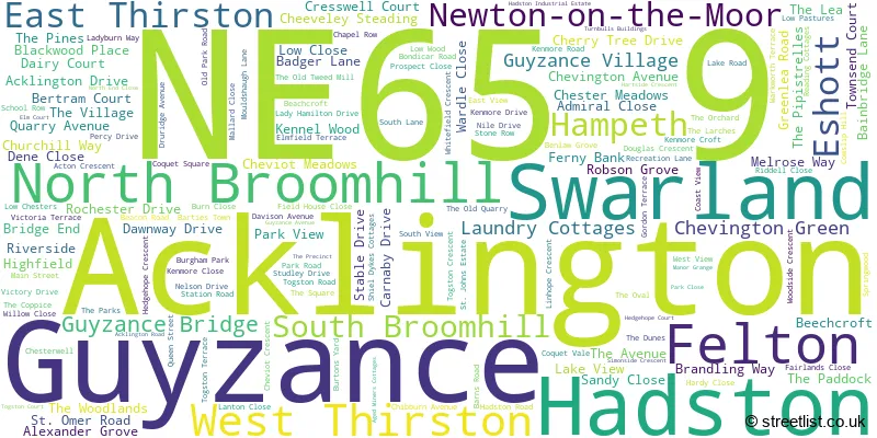
The largest settlement in the NE65 9 postal code is Felton followed by Hadston, and Swarland.
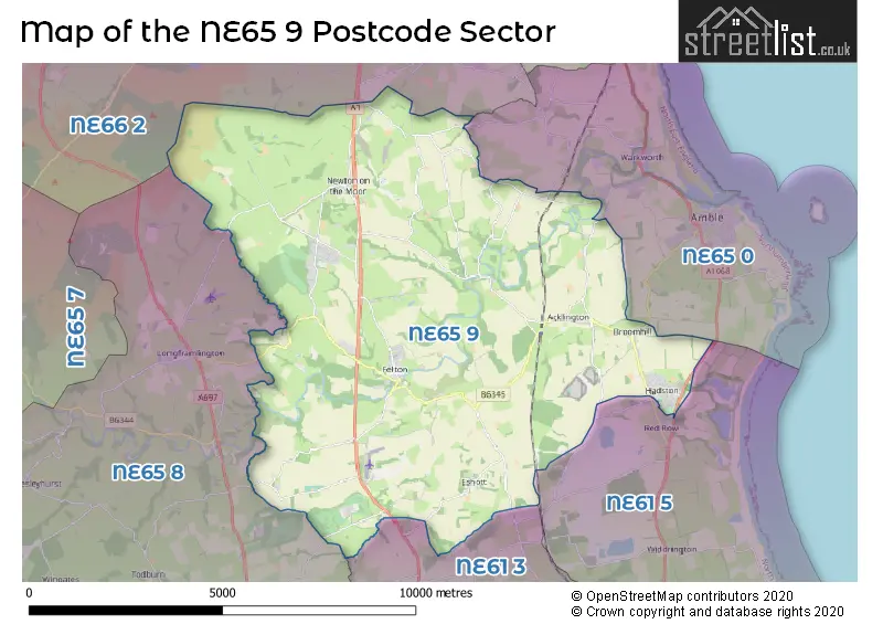
The NE65 9 Postcode shares a border with NE65 8 (Longframlington, Longhorsley, Wingates), NE66 2 (ALNWICK, Shilbottle, Alnmouth), NE61 5 (Widdrington, Ellington, Lynemouth), NE65 0 (Amble, Warkworth, High Hauxley) and NE61 3 (MORPETH, Longhirst, Ulgham).
The sector is within the post town of MORPETH.
NE65 9 is a postcode sector within the NE6 postcode district which is within the NE Newcastle upon Tyne postcode area.
The Royal Mail delivery office for the NE65 9 postal sector is the unknown.
The area of the NE65 9 postcode sector is 37.92 square miles which is 98.21 square kilometres or 24,267.21 square acres.
The NE65 9 postcode sector is crossed by the A1 Major A road.
Waterways within the NE65 9 postcode sector include the Coquet, Grange Burn, Newton Burn, Mere Burn, Hazon Burn.

Map of the NE65 9 Postcode Sector
Explore the NE65 9 postcode sector by using our free interactive map.
| N | E | 6 | 5 | - | 9 | X | X |
| N | E | 6 | 5 | Space | 9 | Letter | Letter |
Official List of Streets
Acklington (14 Streets)
North Broomhill (23 Streets)
Felton (28 Streets)
Swarland (41 Streets)
Hadston (27 Streets)
Eshott (5 Streets)
South Broomhill (4 Streets)
Hampeth (2 Streets)
West Thirston (1 Streets)
Guyzance (1 Streets)
Newton-on-the-Moor (2 Streets)
Unofficial Streets or Alternative Spellings
Warkworth
MORWICK ROADWeather Forecast for NE65 9
Press Button to Show Forecast for Amble
| Time Period | Icon | Description | Temperature | Rain Probability | Wind |
|---|---|---|---|---|---|
| 06:00 to 09:00 | Cloudy | 7.0°C (feels like 4.0°C) | 13.00% | S 9 mph | |
| 09:00 to 12:00 | Cloudy | 10.0°C (feels like 7.0°C) | 12.00% | S 16 mph | |
| 12:00 to 15:00 | Light rain | 12.0°C (feels like 9.0°C) | 41.00% | S 16 mph | |
| 15:00 to 18:00 | Cloudy | 12.0°C (feels like 9.0°C) | 45.00% | S 16 mph | |
| 18:00 to 21:00 | Cloudy | 12.0°C (feels like 8.0°C) | 12.00% | S 18 mph | |
| 21:00 to 00:00 | Cloudy | 11.0°C (feels like 8.0°C) | 6.00% | S 16 mph |
Press Button to Show Forecast for Amble
| Time Period | Icon | Description | Temperature | Rain Probability | Wind |
|---|---|---|---|---|---|
| 00:00 to 03:00 | Cloudy | 10.0°C (feels like 7.0°C) | 4.00% | S 13 mph | |
| 03:00 to 06:00 | Cloudy | 9.0°C (feels like 6.0°C) | 3.00% | SSE 11 mph | |
| 06:00 to 09:00 | Cloudy | 9.0°C (feels like 6.0°C) | 4.00% | SSE 13 mph | |
| 09:00 to 12:00 | Partly cloudy (day) | 11.0°C (feels like 8.0°C) | 1.00% | SSE 16 mph | |
| 12:00 to 15:00 | Sunny day | 13.0°C (feels like 10.0°C) | 0.00% | SE 16 mph | |
| 15:00 to 18:00 | Partly cloudy (day) | 12.0°C (feels like 9.0°C) | 2.00% | SE 18 mph | |
| 18:00 to 21:00 | Cloudy | 11.0°C (feels like 8.0°C) | 5.00% | SE 16 mph | |
| 21:00 to 00:00 | Cloudy | 9.0°C (feels like 7.0°C) | 7.00% | SE 11 mph |
Press Button to Show Forecast for Amble
| Time Period | Icon | Description | Temperature | Rain Probability | Wind |
|---|---|---|---|---|---|
| 00:00 to 03:00 | Cloudy | 9.0°C (feels like 7.0°C) | 9.00% | SE 9 mph | |
| 03:00 to 06:00 | Mist | 9.0°C (feels like 7.0°C) | 19.00% | ESE 7 mph | |
| 06:00 to 09:00 | Cloudy | 9.0°C (feels like 8.0°C) | 13.00% | ESE 4 mph | |
| 09:00 to 12:00 | Cloudy | 11.0°C (feels like 9.0°C) | 12.00% | E 7 mph | |
| 12:00 to 15:00 | Cloudy | 11.0°C (feels like 10.0°C) | 11.00% | E 7 mph | |
| 15:00 to 18:00 | Overcast | 11.0°C (feels like 9.0°C) | 11.00% | ENE 9 mph | |
| 18:00 to 21:00 | Overcast | 9.0°C (feels like 8.0°C) | 11.00% | NE 7 mph | |
| 21:00 to 00:00 | Cloudy | 9.0°C (feels like 7.0°C) | 11.00% | N 9 mph |
Press Button to Show Forecast for Amble
| Time Period | Icon | Description | Temperature | Rain Probability | Wind |
|---|---|---|---|---|---|
| 00:00 to 03:00 | Cloudy | 9.0°C (feels like 6.0°C) | 9.00% | N 11 mph | |
| 03:00 to 06:00 | Overcast | 9.0°C (feels like 6.0°C) | 11.00% | N 13 mph | |
| 06:00 to 09:00 | Cloudy | 9.0°C (feels like 6.0°C) | 8.00% | N 13 mph | |
| 09:00 to 12:00 | Cloudy | 10.0°C (feels like 8.0°C) | 7.00% | N 13 mph | |
| 12:00 to 15:00 | Partly cloudy (day) | 11.0°C (feels like 9.0°C) | 3.00% | NNE 13 mph | |
| 15:00 to 18:00 | Partly cloudy (day) | 11.0°C (feels like 9.0°C) | 1.00% | NNE 13 mph | |
| 18:00 to 21:00 | Cloudy | 10.0°C (feels like 8.0°C) | 4.00% | NNE 13 mph | |
| 21:00 to 00:00 | Partly cloudy (night) | 9.0°C (feels like 6.0°C) | 2.00% | N 11 mph |
Schools and Places of Education Within the NE65 9 Postcode Sector
Broomhill First School
Community school
Station Road, Morpeth, Northumberland, NE65 9UT
Head: Mr Jonathan Smith
Ofsted Rating: Good
Inspection: 2022-05-24 (706 days ago)
Website: Visit Broomhill First School Website
Phone: 01670760339
Number of Pupils: 76
Felton Church of England Primary School
Voluntary controlled school
Mouldshaugh Lane, Morpeth, Northumberland, NE65 9PY
Head: Mrs Emma Lucas
Ofsted Rating: Good
Inspection: 2023-07-11 (293 days ago)
Website: Visit Felton Church of England Primary School Website
Phone: 01670787315
Number of Pupils: 108
Swarland Primary School
Community school
Leamington Lane, Morpeth, Northumberland, NE65 9JP
Head: Mrs Louise Fletcher
Ofsted Rating: Good
Inspection: 2020-01-09 (1572 days ago)
Website: Visit Swarland Primary School Website
Phone: 01670787346
Number of Pupils: 88
House Prices in the NE65 9 Postcode Sector
| Type of Property | 2018 Average | 2018 Sales | 2017 Average | 2017 Sales | 2016 Average | 2016 Sales | 2015 Average | 2015 Sales |
|---|---|---|---|---|---|---|---|---|
| Detached | £284,183 | 91 | £288,623 | 39 | £285,030 | 46 | £338,153 | 45 |
| Semi-Detached | £156,242 | 33 | £161,679 | 39 | £173,150 | 21 | £162,233 | 15 |
| Terraced | £185,592 | 30 | £193,183 | 29 | £183,862 | 42 | £164,940 | 30 |
| Flats | £0 | 0 | £0 | 0 | £480,000 | 2 | £39,000 | 1 |
Important Postcodes NE65 9 in the Postcode Sector
NE65 9JP is the postcode for Swarland Primary School, Leamington Lane, and Swarland County First School, Swarland
NE65 9PY is the postcode for Felton First School, Mouldshaugh Lane
NE65 9SD is the postcode for MAIN BUILDING, Druridge Bay Middle School, Hadston Road
NE65 9SF is the postcode for Broomhill Health Centre, Hadston Road
NE65 9UT is the postcode for Broomhill First School, North Broomhill
NE65 9XF is the postcode for HMP NORTHUMBERLAND, H M Prison, Acklington, and H M Prison, Acklington
NE65 9XG is the postcode for GATEHOUSE & VISITS, H M Young Offenders Institute, Castington, and H M Young Offenders Institute, Castington
NE65 9YF is the postcode for Druridge Bay Community Centre, The Precinct
| The NE65 9 Sector is within these Local Authorities |
|
|---|---|
| The NE65 9 Sector is within these Counties |
|
| The NE65 9 Sector is within these Water Company Areas |
|