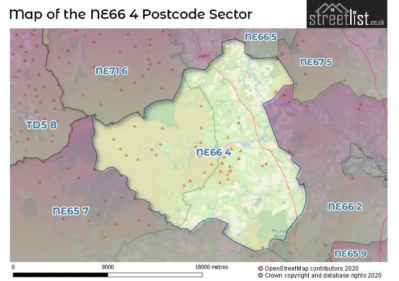
The NE66 4 postcode sector is within the county of Northumberland.
Did you know? According to the 2021 Census, the NE66 4 postcode sector is home to a bustling 1,500 residents!
Given that each sector allows for 400 unique postcode combinations. Letters C, I, K, M, O and V are not allowed in the last two letters of a postcode. With 162 postcodes already in use, this leaves 238 units available.
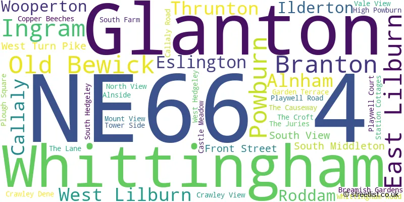
The largest settlement in the NE66 4 postal code is Whittingham followed by Powburn, and Glanton.
The NE66 4 Postcode shares a border with NE65 7 (Rothbury, Thropton, Harbottle), NE66 2 (ALNWICK, Shilbottle, Alnmouth), NE66 5 (Chatton, Chillingham), NE67 5 (Beadnell, CHATHILL, Ellingham) and NE71 6 (WOOLER, Milfield, Kirknewton).
The sector is within the post town of ALNWICK.
NE66 4 is a postcode sector within the NE6 postcode district which is within the NE Newcastle upon Tyne postcode area.
The Royal Mail delivery office for the NE66 4 postal sector is the Heaton Delivery Office.
The area of the NE66 4 postcode sector is 91.72 square miles which is 237.55 square kilometres or 58,699.70 square acres.
Waterways within the NE66 4 postcode sector include the River Till, Fawdon Burn, Fawdon Dean, Aln, Cullaly Burn, Harehope Burn, River Breamish, Rowhope Burn, Smaleshope Burn, Shank Burn, Fore Burn, Cobden Burn, Chesters Burn, Middledean Burn, Reaveley Burn, Kirk Burn, Harelaw Burn, Lilburn Burn, Threestone Burn.

Map of the NE66 4 Postcode Sector
Explore the NE66 4 postcode sector by using our free interactive map.
| N | E | 6 | 6 | - | 4 | X | X |
| N | E | 6 | 6 | Space | 4 | Letter | Letter |
Official List of Streets
Whittingham (11 Streets)
Powburn (7 Streets)
Glanton (13 Streets)
Unofficial Streets or Alternative Spellings
Weather Forecast for NE66 4
Press Button to Show Forecast for Powburn
| Time Period | Icon | Description | Temperature | Rain Probability | Wind |
|---|---|---|---|---|---|
| 06:00 to 09:00 | Light rain shower (day) | 7.0°C (feels like 4.0°C) | 37.00% | S 9 mph | |
| 09:00 to 12:00 | Light rain | 9.0°C (feels like 7.0°C) | 49.00% | S 11 mph | |
| 12:00 to 15:00 | Light rain | 11.0°C (feels like 8.0°C) | 52.00% | S 13 mph | |
| 15:00 to 18:00 | Light rain | 11.0°C (feels like 9.0°C) | 53.00% | S 16 mph | |
| 18:00 to 21:00 | Cloudy | 11.0°C (feels like 8.0°C) | 15.00% | S 16 mph | |
| 21:00 to 00:00 | Cloudy | 10.0°C (feels like 7.0°C) | 13.00% | S 11 mph |
Press Button to Show Forecast for Powburn
| Time Period | Icon | Description | Temperature | Rain Probability | Wind |
|---|---|---|---|---|---|
| 00:00 to 03:00 | Cloudy | 9.0°C (feels like 7.0°C) | 8.00% | S 11 mph | |
| 03:00 to 06:00 | Partly cloudy (night) | 8.0°C (feels like 6.0°C) | 2.00% | SSE 9 mph | |
| 06:00 to 09:00 | Cloudy | 8.0°C (feels like 6.0°C) | 5.00% | SSE 11 mph | |
| 09:00 to 12:00 | Partly cloudy (day) | 11.0°C (feels like 9.0°C) | 1.00% | SSE 13 mph | |
| 12:00 to 15:00 | Partly cloudy (day) | 14.0°C (feels like 11.0°C) | 2.00% | SE 16 mph | |
| 15:00 to 18:00 | Sunny day | 14.0°C (feels like 11.0°C) | 2.00% | SE 16 mph | |
| 18:00 to 21:00 | Partly cloudy (day) | 11.0°C (feels like 9.0°C) | 3.00% | SE 11 mph | |
| 21:00 to 00:00 | Cloudy | 9.0°C (feels like 7.0°C) | 8.00% | SE 9 mph |
Press Button to Show Forecast for Powburn
| Time Period | Icon | Description | Temperature | Rain Probability | Wind |
|---|---|---|---|---|---|
| 00:00 to 03:00 | Mist | 8.0°C (feels like 7.0°C) | 17.00% | SE 4 mph | |
| 03:00 to 06:00 | Fog | 8.0°C (feels like 7.0°C) | 20.00% | SE 4 mph | |
| 06:00 to 09:00 | Fog | 9.0°C (feels like 8.0°C) | 22.00% | ESE 4 mph | |
| 09:00 to 12:00 | Cloudy | 11.0°C (feels like 10.0°C) | 13.00% | ESE 4 mph | |
| 12:00 to 15:00 | Cloudy | 13.0°C (feels like 12.0°C) | 11.00% | E 9 mph | |
| 15:00 to 18:00 | Cloudy | 13.0°C (feels like 11.0°C) | 8.00% | ENE 9 mph | |
| 18:00 to 21:00 | Cloudy | 11.0°C (feels like 9.0°C) | 9.00% | NE 7 mph | |
| 21:00 to 00:00 | Mist | 9.0°C (feels like 7.0°C) | 18.00% | NNE 4 mph |
Press Button to Show Forecast for Powburn
| Time Period | Icon | Description | Temperature | Rain Probability | Wind |
|---|---|---|---|---|---|
| 00:00 to 03:00 | Mist | 8.0°C (feels like 6.0°C) | 17.00% | N 7 mph | |
| 03:00 to 06:00 | Overcast | 8.0°C (feels like 6.0°C) | 13.00% | N 9 mph | |
| 06:00 to 09:00 | Cloudy | 9.0°C (feels like 6.0°C) | 10.00% | N 9 mph | |
| 09:00 to 12:00 | Cloudy | 10.0°C (feels like 8.0°C) | 8.00% | N 11 mph | |
| 12:00 to 15:00 | Cloudy | 12.0°C (feels like 10.0°C) | 6.00% | NNE 11 mph | |
| 15:00 to 18:00 | Cloudy | 12.0°C (feels like 10.0°C) | 4.00% | NNE 11 mph | |
| 18:00 to 21:00 | Cloudy | 11.0°C (feels like 9.0°C) | 5.00% | NNE 11 mph | |
| 21:00 to 00:00 | Cloudy | 9.0°C (feels like 7.0°C) | 6.00% | N 9 mph |
Schools and Places of Education Within the NE66 4 Postcode Sector
Branton Community Primary School
Community school
Branton, Alnwick, Northumberland, NE66 4JF
Head: Mrs Emma Miller
Ofsted Rating: Good
Inspection: 2023-03-29 (397 days ago)
Website: Visit Branton Community Primary School Website
Phone: 01665578225
Number of Pupils: 16
Whittingham Church of England Primary School
Voluntary controlled school
Whittingham, Alnwick, Northumberland, NE66 4UP
Head: Mrs Belinda Athey
Ofsted Rating: Good
Inspection: 2023-03-29 (397 days ago)
Website: Visit Whittingham Church of England Primary School Website
Phone: 01665574222
Number of Pupils: 98
House Prices in the NE66 4 Postcode Sector
| Type of Property | 2018 Average | 2018 Sales | 2017 Average | 2017 Sales | 2016 Average | 2016 Sales | 2015 Average | 2015 Sales |
|---|---|---|---|---|---|---|---|---|
| Detached | £275,200 | 5 | £367,667 | 9 | £356,120 | 12 | £352,500 | 3 |
| Semi-Detached | £256,000 | 6 | £132,125 | 4 | £915,000 | 1 | £499,950 | 1 |
| Terraced | £250,000 | 2 | £120,125 | 6 | £188,357 | 7 | £132,556 | 8 |
| Flats | £0 | 0 | £118,500 | 1 | £0 | 0 | £0 | 0 |
Important Postcodes NE66 4 in the Postcode Sector
NE66 4UP is the postcode for Whittingham C of E First School, Whittingham
| The NE66 4 Sector is within these Local Authorities |
|
|---|---|
| The NE66 4 Sector is within these Counties |
|
| The NE66 4 Sector is within these Water Company Areas |
|